
Following a wet winter, bulrush is shown growing in Malheur Lake. Emergent vegetation like bulrush provides nesting habitat and food resources for birds.
Casie Smith
Casie Smith is an ecologist at the USGS Oregon Water Science Center who works in Bend, Oregon.
Recent projects involve:
-monitoring linkages between water availability, water quality, and productivity in terminal lakes of the Great Basin,
-developing a decision-support tool to optimize water allocations and habitat management on federal lands,
-assessing restoration scenarios for a degraded lake to inform resource management, and
-evaluating the fate and transport of contaminants in aquatic systems and drinking water.
Science and Products
Continuous water quality datasets
View continuous datasets collected by the Saline Lake Ecosystems Integrated Water Availability Assessment Water Quality Team. During the 2024 and 2025 field seasons, the Water Quality Team collected 63 datasets at saline lakes across the Great Basin. Each dataset is a single parameter recorded continuously during the field season - April through October - or until the lake levels became too...

Water Quality
The USGS, in partnership with multiple other groups, is learning about water-quality conditions across time and space in terminal lakes across the Great Basin. This effort is part of the Saline Lake Ecosystems Integrated Water Availability Assessment.

Oregon Water Science Center's Malheur Lake Portfolio
USGS scientists have partnered with local groups to learn about the processes affecting turbidity in Malheur Lake. Located in southeastern Oregon, Malheur Lake and the surrounding refuge provide critical habitat to birds migrating along the Pacific Flyway.

Water Quality in Willow Creek Reservoir, Oregon
Blue-green algal blooms in the Willow Creek Reservoir may produce toxins that can be harmful to those that come in contact with them.

Bulrush growing in Malheur Lake
Following a wet winter, bulrush is shown growing in Malheur Lake. Emergent vegetation like bulrush provides nesting habitat and food resources for birds.

American coot nest in Malheur Lake
An American coot nest in Malheur Lake was built with bulrush and floated on the surface even as waves passed by.
An American coot nest in Malheur Lake was built with bulrush and floated on the surface even as waves passed by.

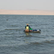
Wave reduction barriers and a wind sensor in Malheur Lake
Wave reduction barriers and a wind sensor in Malheur LakeWave reduction barriers were installed around some mesocosms to test whether reducing wind-wave action would reduce suspended sediment in the water column.
Wave reduction barriers and a wind sensor in Malheur Lake
Wave reduction barriers and a wind sensor in Malheur LakeWave reduction barriers were installed around some mesocosms to test whether reducing wind-wave action would reduce suspended sediment in the water column.

Malheur Lake
Malheur Lake is shown with turbid water and without emergent vegetation. Snowpack from Steens Mountain (shown in the distance) provides most of the inflow to Malheur Lake.
Malheur Lake is shown with turbid water and without emergent vegetation. Snowpack from Steens Mountain (shown in the distance) provides most of the inflow to Malheur Lake.

Algal bloom in WIllow Creek Reservoir, Oregon
Algal bloom in WIllow Creek Reservoir, Oregon, taken during a photointerpretive study of the lake.
Algal bloom in WIllow Creek Reservoir, Oregon, taken during a photointerpretive study of the lake.

Willow Creek Reservoir, Oregon
View of the Willow Creek Reservoir near Heppner, OR
View of the Willow Creek Reservoir near Heppner, OR
Science and Products
Continuous water quality datasets
View continuous datasets collected by the Saline Lake Ecosystems Integrated Water Availability Assessment Water Quality Team. During the 2024 and 2025 field seasons, the Water Quality Team collected 63 datasets at saline lakes across the Great Basin. Each dataset is a single parameter recorded continuously during the field season - April through October - or until the lake levels became too...
Water Quality
The USGS, in partnership with multiple other groups, is learning about water-quality conditions across time and space in terminal lakes across the Great Basin. This effort is part of the Saline Lake Ecosystems Integrated Water Availability Assessment.
Oregon Water Science Center's Malheur Lake Portfolio
USGS scientists have partnered with local groups to learn about the processes affecting turbidity in Malheur Lake. Located in southeastern Oregon, Malheur Lake and the surrounding refuge provide critical habitat to birds migrating along the Pacific Flyway.
Water Quality in Willow Creek Reservoir, Oregon
Blue-green algal blooms in the Willow Creek Reservoir may produce toxins that can be harmful to those that come in contact with them.
Bulrush growing in Malheur Lake
Following a wet winter, bulrush is shown growing in Malheur Lake. Emergent vegetation like bulrush provides nesting habitat and food resources for birds.
Following a wet winter, bulrush is shown growing in Malheur Lake. Emergent vegetation like bulrush provides nesting habitat and food resources for birds.
American coot nest in Malheur Lake
An American coot nest in Malheur Lake was built with bulrush and floated on the surface even as waves passed by.
An American coot nest in Malheur Lake was built with bulrush and floated on the surface even as waves passed by.
Wave reduction barriers and a wind sensor in Malheur Lake
Wave reduction barriers and a wind sensor in Malheur LakeWave reduction barriers were installed around some mesocosms to test whether reducing wind-wave action would reduce suspended sediment in the water column.
Wave reduction barriers and a wind sensor in Malheur Lake
Wave reduction barriers and a wind sensor in Malheur LakeWave reduction barriers were installed around some mesocosms to test whether reducing wind-wave action would reduce suspended sediment in the water column.
Malheur Lake
Malheur Lake is shown with turbid water and without emergent vegetation. Snowpack from Steens Mountain (shown in the distance) provides most of the inflow to Malheur Lake.
Malheur Lake is shown with turbid water and without emergent vegetation. Snowpack from Steens Mountain (shown in the distance) provides most of the inflow to Malheur Lake.
Algal bloom in WIllow Creek Reservoir, Oregon
Algal bloom in WIllow Creek Reservoir, Oregon, taken during a photointerpretive study of the lake.
Algal bloom in WIllow Creek Reservoir, Oregon, taken during a photointerpretive study of the lake.
Willow Creek Reservoir, Oregon
View of the Willow Creek Reservoir near Heppner, OR
View of the Willow Creek Reservoir near Heppner, OR