Chris Holmquist-Johnson, PhD, PE
Chris Holmquist-Johnson is a Hydrologist and UAS Pilot with the USGS Fort Collins Science Center’s Ecosystem and Organismal Ecology (EcOE) branch. His research focuses on studying the response of riverine and riparian species and habitats to flow alteration, drought, and dam management in support of conservation and restoration of community structure and function—especially for at-risk species.
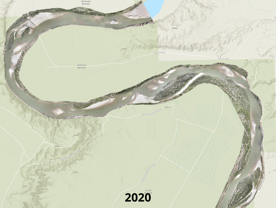
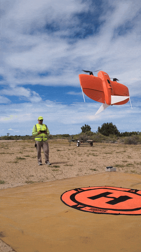
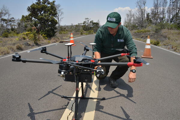
Chris' research includes integrated riverine ecosystem studies, aquatic habitat assessment, in-stream flow modeling and decision support system development. In 2010 he obtained his remote pilot certification for Uncrewed Aircraft Systems (UAS) and is involved with numerous UAS operations within DOI and USGS related to terrestrial wildlife, hydrologic mapping, habitat mapping/analysis, river system processes, and emergency response utilizing natural color, multi-spectral, thermal, and LiDAR sensors. His work also includes collaborations with the USGS National Uncrewed Systems Office (NUSO) in supporting the integration of UAS data collection into the scientific, monitoring, and resource management functions of the Department of the Interior (DOI). Strategic implementation of UAS within the USGS focuses on the evaluation and integration of new innovative sensors, development of data standards and processing techniques, recommendations of UAS data acquisition best-practices, and support for the training and proficiency of new and existing UAS operators within USGS.
Professional Experience
2008–present, Hydrologist and UAS Pilot, USGS Fort Collins Science Center, Fort Collins, CO
2004-2008, Hydraulic Engineer, Bureau of Reclamation Erosion and Sedimentation Group, Denver, CO
2003-2004, Hydraulic Engineer, Tetra Tech Inc., Breckenridge, CO
Education and Certifications
Ph.D. in Civil and Environmental Engineering, Colorado State University, 2011
M.S. in Civil and Environmental Engineering, Colorado State University, 2002
B.S. in Civil Engineering, Colorado State University, 1999
Science and Products
Environmental Flows for Riverine EcoSystem Habitats (E-FRESH) decision support tool user guide
Predicting bird guilds using vegetation composition and structure on a wild and scenic river in Arizona
Efficient hydrogeological characterization of remote stream corridors using drones
Development of a decision support tool for water and resource management using biotic, abiotic, and hydrological assessments of Topock Marsh, Arizona
Experimental flights using a small unmanned aircraft system for mapping emergent sandbars
Evaluation of the Raven sUAS to detect and monitor greater sage-grouse leks within the Middle Park population
User's manual for the upper Delaware River riverine environmental flow decision support system (REFDSS), Version 1.1.2
Channel Maintenance and Flushing Flows for the Klamath River Below Iron Gate Dam, California
Relation between Streamflow of Swiftcurrent Creek, Montana, and the Geometry of Passage for Bull Trout (Salvelinus confluentus)
Qualitative evaluation of rock weir field performance and failure mechanisms
Non-USGS Publications**
**Disclaimer: The views expressed in Non-USGS publications are those of the author and do not represent the views of the USGS, Department of the Interior, or the U.S. Government.
Integrated River and Riparian Ecosystem Studies
Water Management Studies
Small Unoccupied Aircraft System (sUAS) Flights
LiDAR, natural color and thermal infrared data collected by uncrewed aircraft system (UAS) for mapping topography and stream temperature along the Vermilion River, Montana, August and October 2023
High resolution natural color imagery collected by uncrewed aircraft system (UAS) for mapping channel and vegetation change along a 6-mile reach of the Middle Green River at Ouray National Wildlife Refuge near Ouray, Utah from 2020-2023
High resolution natural color imagery collected by uncrewed aircraft system (UAS) for mapping channel and vegetation change along a 7-mile reach of the Middle Green River at Horseshoe Bend near Jensen, Utah from 2020-2023
High resolution natural color imagery collected by uncrewed aircraft system (UAS) for mapping channel and vegetation change along a 2-mile reach of the Middle Green River at Grays Canyon near Green River, Utah from 2021-2023
Orthoimagery, digital elevation, digital terrain, final surface, and vegetation classification models for four stream catchments in western Colorado 2016
Photogrammetric data collected by small unoccupied aircraft system for vegetation analysis at three study reaches along the Verde River, Arizona, December 2017
Orthoimagery and elevation data derived from UAS imagery for Palmyra Atoll, USA 2016 (ver. 1.1, November 2020)
Thermal infrared, multispectral, and photogrammetric data collected by drone for hydrogeologic analysis of the East River and Coal Creek beaver-impacted corridors near Crested Butte, Colorado
Thermal infrared and photogrammetric data collected by small unoccupied aircraft system for hydrogeologic analysis of Oh-be-joyful Creek, Gunnison National Forest, Colorado, August 2017
Physical Habitat Simulation (PHABSIM) Software for Windows
Science and Products
Environmental Flows for Riverine EcoSystem Habitats (E-FRESH) decision support tool user guide
Predicting bird guilds using vegetation composition and structure on a wild and scenic river in Arizona
Efficient hydrogeological characterization of remote stream corridors using drones
Development of a decision support tool for water and resource management using biotic, abiotic, and hydrological assessments of Topock Marsh, Arizona
Experimental flights using a small unmanned aircraft system for mapping emergent sandbars
Evaluation of the Raven sUAS to detect and monitor greater sage-grouse leks within the Middle Park population
User's manual for the upper Delaware River riverine environmental flow decision support system (REFDSS), Version 1.1.2
Channel Maintenance and Flushing Flows for the Klamath River Below Iron Gate Dam, California
Relation between Streamflow of Swiftcurrent Creek, Montana, and the Geometry of Passage for Bull Trout (Salvelinus confluentus)
Qualitative evaluation of rock weir field performance and failure mechanisms
Non-USGS Publications**
**Disclaimer: The views expressed in Non-USGS publications are those of the author and do not represent the views of the USGS, Department of the Interior, or the U.S. Government.