
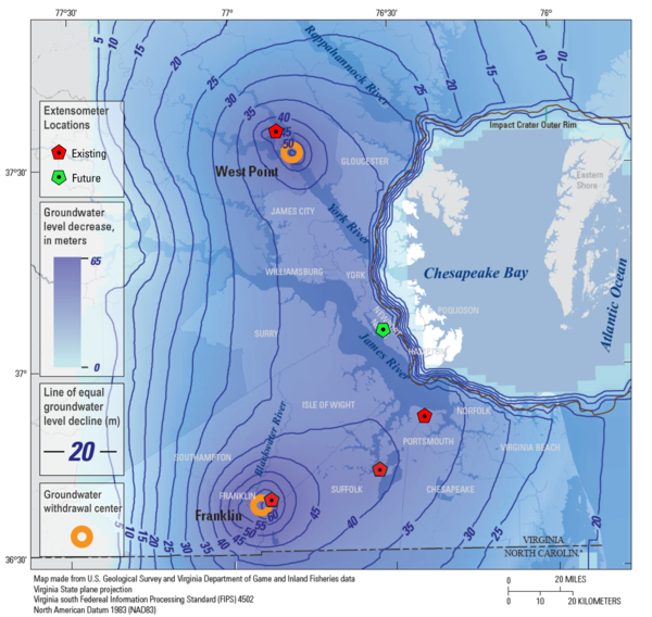
This map shows the locations of the four existing extensometers (red) in the USGS' Virginia Extensometer Network with the location of a fifth future extensometer (green). The basemap is of the Virginia Coastal Plain and shows the severity of groundwater depletion, with darker blue indicating greater groundwater depletion.
Gregory T. Connock, Ph.D
Greg joined the U.S. Geological Survey as a Geologist in 2021. His current focus centers on the expansion of the subsidence-monitoring network along the Coastal Plain of Virginia. Other interests include investigating the applicability of organic geochemical techniques to supplement conventional hydrogeologic approaches in groundwater studies.
Greg is currently serving as Project Chief of a multiyear drilling project (2022-2025) in cooperation with the Virginia Department of Environmental Quality, which aims to expand the extensometer, chloride monitoring, and climate response networks across Virginia. He also supplements ongoing efforts related to groundwater modeling on the Eastern Shore of Virginia.
Science and Products

The Virginia Extensometer Network
Borehole extensometers are instruments that monitor land subsidence caused by aquifer compaction. They provide precise, high-resolution measurements of changes in aquifer-system thickness. These changes in aquifer-system thickness contribute to vertical land motion (VLM) across the Virginia Coastal Plain, and are driven primarily by groundwater level decline due to human water usage. The Virginia...

Land Subsidence on the Virginia Coastal Plain
Land subsidence is a loss of ground elevation, often experienced as the ground slowly sinking over the course of years. In eastern Virginia, high rates of groundwater use is a major factor in the land subsidence affecting the area. The Virginia-West Virginia Water Science Center, with the help of our partners, has been monitoring land subsidence in the Virginia Coastal Plain since 1979 using a...

Virginia Coastal Plain Aquifer System and Groundwater Resources
Groundwater is a heavily used source of water in the Virginia Coastal Plain. Long term and widespread groundwater withdrawals have resulted in regional water-level declines, and created the potential for saltwater intrusion. Sound management of this vital resource relies on continual improvement of the scientific understanding of the aquifer system.
Virginia Extensometer Network
This map shows the locations of the four existing extensometers (red) in the USGS' Virginia Extensometer Network with the location of a fifth future extensometer (green). The basemap is of the Virginia Coastal Plain and shows the severity of groundwater depletion, with darker blue indicating greater groundwater depletion.
Science and Products
The Virginia Extensometer Network
Borehole extensometers are instruments that monitor land subsidence caused by aquifer compaction. They provide precise, high-resolution measurements of changes in aquifer-system thickness. These changes in aquifer-system thickness contribute to vertical land motion (VLM) across the Virginia Coastal Plain, and are driven primarily by groundwater level decline due to human water usage. The Virginia...
Land Subsidence on the Virginia Coastal Plain
Land subsidence is a loss of ground elevation, often experienced as the ground slowly sinking over the course of years. In eastern Virginia, high rates of groundwater use is a major factor in the land subsidence affecting the area. The Virginia-West Virginia Water Science Center, with the help of our partners, has been monitoring land subsidence in the Virginia Coastal Plain since 1979 using a...
Virginia Coastal Plain Aquifer System and Groundwater Resources
Groundwater is a heavily used source of water in the Virginia Coastal Plain. Long term and widespread groundwater withdrawals have resulted in regional water-level declines, and created the potential for saltwater intrusion. Sound management of this vital resource relies on continual improvement of the scientific understanding of the aquifer system.
Virginia Extensometer Network
This map shows the locations of the four existing extensometers (red) in the USGS' Virginia Extensometer Network with the location of a fifth future extensometer (green). The basemap is of the Virginia Coastal Plain and shows the severity of groundwater depletion, with darker blue indicating greater groundwater depletion.
This map shows the locations of the four existing extensometers (red) in the USGS' Virginia Extensometer Network with the location of a fifth future extensometer (green). The basemap is of the Virginia Coastal Plain and shows the severity of groundwater depletion, with darker blue indicating greater groundwater depletion.