
In West Point, Virginia, a New 'Subsidence Superstation' Measures Changing Land Surface
West Point, Virginia is believed to be a subsidence hotspot, a fast-sinking region in eastern Virginia. A new 'Subsidence Superstation' will help shed light on what might be driving this subsidence in West Point and beyond. The cornerstone of this new superstation is an extensometer, a device that measures subsurface compaction with amazing precision.

On December 11th 2024, USGS scientists finished installation of a brand-new extensometer in West Point, Virginia. Though housed in a simple, nondescript building, this state-of-the-art piece of equipment is only the fourth of its kind on the East Coast.
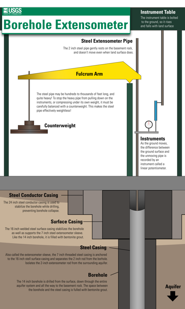
Extensometers are instruments that measure certain kinds of land motion. They extend hundreds to thousands of feet below the ground, and measure changes in the thickness of the geologic layers they pass through. Some aquifers, or geologic layers that hold and transmit groundwater, can compact under the weight of the ground above if groundwater levels are reduced. If a layer such as an aquifer compacts, the ground surface sinks, or subsides, and the extensometer can measure this subsidence with incredible precision. This new extensometer at West Point is so sensitive, that it can measure upward or downward motion of the ground by fractions of a millimeter (0.01 - 0.05 mm).
That's smaller than the thickness of a sheet of paper!

The instrument itself consists of a borehole similar to a well which extends a whopping 1,371 ft. below the ground surface, and a steel rod which extends from the base of the borehole all the way to the surface. This rod is carefully counter-balanced at the surface so that it rests nearly-weightlessly at the bottom of the borehole. Pressure transducers record minute changes in how much of the extensometer rod is protruding from the ground, and this is converted into a measure of land motion.
The West Point extensometer, along with older extensometers in Franklin, Suffolk, and Nansemond, form key pillars of the USGS Virginia Vertical Land Motion Monitoring Network, which is supported by the Hampton Roads Sanitation District, the Virginia Department of Environmental Quality, the Hampton Roads Planning District Commission, and USGS Chesapeake Bay Studies. This network is collecting important data that will help Virginians understand where and how fast portions of eastern Virginia are sinking, which will inform how the area adapts to rising sea level. Coastal Virginia is experiencing the highest rates of relative sea level rise of anywhere on the East Coast.
West Point will be the second of three Land Motion Observatories, or 'Subsidence Superstations', located across eastern Virginia. The first Land Motion Observatory is located in Nansemond, and the third will be installed in Newport News in the coming year. Each of these locations will have not only an extensometer to measure compaction, but also observation wells to track groundwater levels, and continuous GPS receivers and synthetic aperture radar corner reflectors so that land motion can be measured using satellites. Each of these methods of measuring subsidence provides scientists with data they can use to isolate what the main causes of sinking land might be in eastern Virginia.
Related

Land Subsidence on the Virginia Coastal Plain

The Virginia Extensometer Network

New Crowd Sourcing Will Contribute to Study of Land Subsidence and Sea-Level Rise in the Chesapeake Bay

Extensometers and Compaction

Piezometers and Groundwater Levels

Aquifer Compaction due to Groundwater Pumping

Hampton Roads Benchmark Monitoring Network
West Point Extensometer


Extesnometer Infographics


Related
Land Subsidence on the Virginia Coastal Plain
The Virginia Extensometer Network
New Crowd Sourcing Will Contribute to Study of Land Subsidence and Sea-Level Rise in the Chesapeake Bay
Extensometers and Compaction
Piezometers and Groundwater Levels
Aquifer Compaction due to Groundwater Pumping