
War Branch is a creek in Rockingham County, Virginia. Its 11 square mile watershed includes mostly poultry and beef agricultural activities. This stream is a part of the Chesapeake Bay Small Agricultural Watershed Monitoring Program.
James Webber
Jimmy Webber is the Associate Coordinator of USGS Chesapeake Bay studies.
Jimmy has been a hydrologist with the USGS since 2012 and has collaborated extensively with science centers throughout the mid-Atlantic region. He has led many Chesapeake Bay science activities in coordination with federal, state, and local partners. His work has focused on understanding the factors affecting water quality in small agricultural and urban streams, as well as explaining nutrient and sediment trends in large Chesapeake Bay rivers. He has a Bachelor’s degree in Environmental Resource Management and a Master’s degree in Forest Resources from the Pennsylvania State University.
Science and Products
Informing Chesapeake Bay Watershed Management by Monitoring Trends in River Nutrient and Sediment Loads
The USGS has computed nutrient and suspended-sediment loads and trends through water year 2023 in Chesapeake Bay rivers. These monitoring-based estimates help federal, state, and local managers evaluate and plan water-quality restoration strategies.
USGS Chesapeake Accomplishments and Highlights for 2024
As a home to 18 million people and a destination for countless visitors seeking recreational opportunities, the health of the Chesapeake Bay watershed is of critical importance. The U.S. Geological Survey (USGS) is a leading provider of data-driven insights about the condition of the watershed’s lands, waters, fish, and wildlife. These insights and our collaborative work with partners throughout...

New insights for reducing nutrient and sediment loads in agricultural watersheds prioritized for management activities
Agricultural activities and natural factors may offset nutrient and sediment reductions from management activities.

Monitoring the Effectiveness of Conservation Practices in Small Agricultural Watersheds
Farmers are an important part of the economy and heritage of the Chesapeake Bay. Farmers also act as stewards of the land and water. Across the Chesapeake Bay Watershed, members of the agricultural community are volunteering to adopt conservation practices on their land. The goal of these practices is to protect the health of the soil, local streams and rivers, and the Chesapeake Bay. These...

USGS Publications Summarize Water-Quality Trends and Drivers in Urban Streams After 10 Years of Monitoring in Fairfax County, Virginia
Issue: Degraded water quality and ecology in urban streams has been widely documented, but explanations of changing conditions over time are often unavailable. A 15-year collaborative urban stream monitoring effort between the Fairfax County Stormwater Planning Division and the U.S. Geological Survey (USGS) is ongoing and has begun to shed light on this complex issue. In a new USGS report by...

Summarizing Science to Inform Management in the Chesapeake Bay Watershed
Stakeholders can use scientific insights to address their priority water-quality concerns. The USGS works with Chesapeake Bay stakeholders to identify and address priority questions that can help inform management decisions. These scientific insights can help guide nutrient and sediment management activities undertaken by Chesapeake Bay stakeholders. This webpage summarizes recent scientific...

Science to Inform Management Priorities from Loads to Endpoints (SIMPLE)
Resource managers are working to improve water-quality in the Chesapeake to benefit the people who live in the region and the birds, fish, and other animals who rely on clean water in the watershed and the Bay. The U.S Geological Survey (USGS) supports resource managers and other Chesapeake stakeholders by providing science that informs restoration and conservation in the Chesapeake region. The...

Summarizing Scientific Findings for Common Stakeholder Questions to Inform Nutrient and Sediment Management Activities in the Chesapeake Bay Watershed
Issue: The Chesapeake Bay Program (CBP) partnership is striving to improve water-quality conditions in the Bay by using a variety of management strategies to reduce nutrient and sediment loads. The partnership uses monitoring results and modeling tools to implement management strategies, relying on the scientific community to synthesize existing information and direct new research to address...

Freshwater Flow into Chesapeake Bay
Explore resources here describing estimates of freshwater flow entering Chesapeake Bay. The health of the Chesapeake Bay is greatly affected by freshwater flow from rivers draining its watershed. The amount of freshwater flow (also called streamflow) will: • Change salinity levels in the Bay, which affect oysters, crabs, and finfish. • Influence the amounts of nutrients, sediment, and contaminants...

Hydrologic Monitoring and Analysis to Support Water Resource Management in the City of Roanoke
The U.S. Geological Survey, partnering with the City of Roanoke and Virginia Tech, are working to monitor the water volume and quality in streams throughout the City of Roanoke. There are currently six monitoring stations within the city. Water-quality data are collected at five stations through real-time monitors. The overall objective of the study is to quantify the amount of sediment delivered...

Chesapeake Bay Water-Quality Loads and Trends
Access the most recent data gathered from the Chesapeake Bay Nontidal Monitoring Network, learn about the techniques used to collect this data, and read about the history of the Chesapeake Bay Nontidal Monitoring Program. Nontidal Network (NTN) data refers to data from the 123 monitoring stations where nutrients and sediment are collected monthly and during storms. River Input Monitoring (RIM)...

War Branch
War Branch is a creek in Rockingham County, Virginia. Its 11 square mile watershed includes mostly poultry and beef agricultural activities. This stream is a part of the Chesapeake Bay Small Agricultural Watershed Monitoring Program.

War Branch
War Branch is a creek in Rockingham County, Virginia. Its 11 square mile watershed includes mostly poultry and beef agricultural activities. This stream is a part of the Chesapeake Bay Small Agricultural Watershed Monitoring Program.
War Branch is a creek in Rockingham County, Virginia. Its 11 square mile watershed includes mostly poultry and beef agricultural activities. This stream is a part of the Chesapeake Bay Small Agricultural Watershed Monitoring Program.

North Fork of the Shenandoah River after a rainstorm
North Fork of the Shenandoah River after a rainstormView from bridge at USGS streamgage (station ID: 01634000) of North Fork of the Shenandoah River after a rainstorm.
Winter 2024 Photo Contest: James Webber, Honorable Mention category
North Fork of the Shenandoah River after a rainstorm
North Fork of the Shenandoah River after a rainstormView from bridge at USGS streamgage (station ID: 01634000) of North Fork of the Shenandoah River after a rainstorm.
Winter 2024 Photo Contest: James Webber, Honorable Mention category

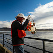
Collecting water samples from the James River
A USGS hydrologist conducts horizontally-integrated synoptic water sampling of the James River at Cartersville as part of the USGS's nontidal network monitoring efforts.
A USGS hydrologist conducts horizontally-integrated synoptic water sampling of the James River at Cartersville as part of the USGS's nontidal network monitoring efforts.
Science and Products
Informing Chesapeake Bay Watershed Management by Monitoring Trends in River Nutrient and Sediment Loads
The USGS has computed nutrient and suspended-sediment loads and trends through water year 2023 in Chesapeake Bay rivers. These monitoring-based estimates help federal, state, and local managers evaluate and plan water-quality restoration strategies.
USGS Chesapeake Accomplishments and Highlights for 2024
As a home to 18 million people and a destination for countless visitors seeking recreational opportunities, the health of the Chesapeake Bay watershed is of critical importance. The U.S. Geological Survey (USGS) is a leading provider of data-driven insights about the condition of the watershed’s lands, waters, fish, and wildlife. These insights and our collaborative work with partners throughout...
New insights for reducing nutrient and sediment loads in agricultural watersheds prioritized for management activities
Agricultural activities and natural factors may offset nutrient and sediment reductions from management activities.
Monitoring the Effectiveness of Conservation Practices in Small Agricultural Watersheds
Farmers are an important part of the economy and heritage of the Chesapeake Bay. Farmers also act as stewards of the land and water. Across the Chesapeake Bay Watershed, members of the agricultural community are volunteering to adopt conservation practices on their land. The goal of these practices is to protect the health of the soil, local streams and rivers, and the Chesapeake Bay. These...
USGS Publications Summarize Water-Quality Trends and Drivers in Urban Streams After 10 Years of Monitoring in Fairfax County, Virginia
Issue: Degraded water quality and ecology in urban streams has been widely documented, but explanations of changing conditions over time are often unavailable. A 15-year collaborative urban stream monitoring effort between the Fairfax County Stormwater Planning Division and the U.S. Geological Survey (USGS) is ongoing and has begun to shed light on this complex issue. In a new USGS report by...
Summarizing Science to Inform Management in the Chesapeake Bay Watershed
Stakeholders can use scientific insights to address their priority water-quality concerns. The USGS works with Chesapeake Bay stakeholders to identify and address priority questions that can help inform management decisions. These scientific insights can help guide nutrient and sediment management activities undertaken by Chesapeake Bay stakeholders. This webpage summarizes recent scientific...
Science to Inform Management Priorities from Loads to Endpoints (SIMPLE)
Resource managers are working to improve water-quality in the Chesapeake to benefit the people who live in the region and the birds, fish, and other animals who rely on clean water in the watershed and the Bay. The U.S Geological Survey (USGS) supports resource managers and other Chesapeake stakeholders by providing science that informs restoration and conservation in the Chesapeake region. The...
Summarizing Scientific Findings for Common Stakeholder Questions to Inform Nutrient and Sediment Management Activities in the Chesapeake Bay Watershed
Issue: The Chesapeake Bay Program (CBP) partnership is striving to improve water-quality conditions in the Bay by using a variety of management strategies to reduce nutrient and sediment loads. The partnership uses monitoring results and modeling tools to implement management strategies, relying on the scientific community to synthesize existing information and direct new research to address...
Freshwater Flow into Chesapeake Bay
Explore resources here describing estimates of freshwater flow entering Chesapeake Bay. The health of the Chesapeake Bay is greatly affected by freshwater flow from rivers draining its watershed. The amount of freshwater flow (also called streamflow) will: • Change salinity levels in the Bay, which affect oysters, crabs, and finfish. • Influence the amounts of nutrients, sediment, and contaminants...
Hydrologic Monitoring and Analysis to Support Water Resource Management in the City of Roanoke
The U.S. Geological Survey, partnering with the City of Roanoke and Virginia Tech, are working to monitor the water volume and quality in streams throughout the City of Roanoke. There are currently six monitoring stations within the city. Water-quality data are collected at five stations through real-time monitors. The overall objective of the study is to quantify the amount of sediment delivered...
Chesapeake Bay Water-Quality Loads and Trends
Access the most recent data gathered from the Chesapeake Bay Nontidal Monitoring Network, learn about the techniques used to collect this data, and read about the history of the Chesapeake Bay Nontidal Monitoring Program. Nontidal Network (NTN) data refers to data from the 123 monitoring stations where nutrients and sediment are collected monthly and during storms. River Input Monitoring (RIM)...
War Branch
War Branch is a creek in Rockingham County, Virginia. Its 11 square mile watershed includes mostly poultry and beef agricultural activities. This stream is a part of the Chesapeake Bay Small Agricultural Watershed Monitoring Program.
War Branch is a creek in Rockingham County, Virginia. Its 11 square mile watershed includes mostly poultry and beef agricultural activities. This stream is a part of the Chesapeake Bay Small Agricultural Watershed Monitoring Program.
North Fork of the Shenandoah River after a rainstorm
North Fork of the Shenandoah River after a rainstormView from bridge at USGS streamgage (station ID: 01634000) of North Fork of the Shenandoah River after a rainstorm.
Winter 2024 Photo Contest: James Webber, Honorable Mention category
North Fork of the Shenandoah River after a rainstorm
North Fork of the Shenandoah River after a rainstormView from bridge at USGS streamgage (station ID: 01634000) of North Fork of the Shenandoah River after a rainstorm.
Winter 2024 Photo Contest: James Webber, Honorable Mention category
Collecting water samples from the James River
A USGS hydrologist conducts horizontally-integrated synoptic water sampling of the James River at Cartersville as part of the USGS's nontidal network monitoring efforts.
A USGS hydrologist conducts horizontally-integrated synoptic water sampling of the James River at Cartersville as part of the USGS's nontidal network monitoring efforts.