Long Island Sound Nitrogen Loading Dashboard Image
Long Island Sound Nitrogen Loading Dashboard ImageA screen capture of an interactive web application that displays Nitrogen Loading from Selected Long Island Sound Tributaries from 1995 to 2021.

Official websites use .gov
A .gov website belongs to an official government organization in the United States.
Secure .gov websites use HTTPS
A lock () or https:// means you’ve safely connected to the .gov website. Share sensitive information only on official, secure websites.
John Mullaney is a Scientist Emeritus with the New England Water Science Center.
John R. Mullaney, a USGS emeritus scientist, has studied groundwater and water quality in Connecticut and New England for four decades. His work includes regional and national studies on nutrient loading to estuaries, groundwater quality, groundwater–surface water interactions, and groundwater recharge and storage.
His current interest is to improve the understanding of drought in New England through analysis of groundwater levels, recharge patterns, and base flows. A secondary interest is improving public access to water-resources information through statistical analysis and visualization.


A screen capture of an interactive web application that displays Nitrogen Loading from Selected Long Island Sound Tributaries from 1995 to 2021.
A screen capture of an interactive web application that displays Nitrogen Loading from Selected Long Island Sound Tributaries from 1995 to 2021.

Stratified sand in an excavation near the Connecticut River in Portland, Connecticut. The sand was deposited as a delta in a glacial lake that occupied the Connecticut River Valley about 18,000-19,000 years ago.
Stratified sand in an excavation near the Connecticut River in Portland, Connecticut. The sand was deposited as a delta in a glacial lake that occupied the Connecticut River Valley about 18,000-19,000 years ago.
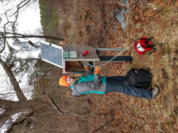
A Geoscientist-in-the-Park Guest Scientist for the National Park Service services a USGS groundwater well located within the Mill Creek basin near the Herring River in Wellfleet, Massachusetts.
A Geoscientist-in-the-Park Guest Scientist for the National Park Service services a USGS groundwater well located within the Mill Creek basin near the Herring River in Wellfleet, Massachusetts.

A gage on the backside of a tide control structure on the Herring River at Chequessett Neck Rd at Wellfleet, Massachusetts. It is evident to see the movement of incoming tide in this picture. Data was collected at this site for several years prior to the removal of the dike in 2023.
A gage on the backside of a tide control structure on the Herring River at Chequessett Neck Rd at Wellfleet, Massachusetts. It is evident to see the movement of incoming tide in this picture. Data was collected at this site for several years prior to the removal of the dike in 2023.

A look to the north along the bluffs at the Cape Cod National Seashore, from Marconi Station. Over the years, the USGS continues to work with the National Park Service at the Cape Cod National Seashore.
A look to the north along the bluffs at the Cape Cod National Seashore, from Marconi Station. Over the years, the USGS continues to work with the National Park Service at the Cape Cod National Seashore.

Hydrologic technician installs a storm-tide sensor ahead of Hurricane Sandy in Milford Harbor, Connecticut.
Hydrologic technician installs a storm-tide sensor ahead of Hurricane Sandy in Milford Harbor, Connecticut.

USGS hydrologist holding a dry erase board to identify the storm surge sensor location deployment on August 27, 2011. The sensor is strapped to the back of a dock piling on the Saugatuck River in Westport, CT owned by the Saugatuck River Rowing Club.
USGS hydrologist holding a dry erase board to identify the storm surge sensor location deployment on August 27, 2011. The sensor is strapped to the back of a dock piling on the Saugatuck River in Westport, CT owned by the Saugatuck River Rowing Club.

USGS hydrologist pointing to the location of a storm surge sensor deployment near the mouth of the Housatonic River in Stratford, CT at the Sikorsky aircraft facility on August 27, 2011.
USGS hydrologist pointing to the location of a storm surge sensor deployment near the mouth of the Housatonic River in Stratford, CT at the Sikorsky aircraft facility on August 27, 2011.
A screen capture of an interactive web application that displays Nitrogen Loading from Selected Long Island Sound Tributaries from 1995 to 2021.
A screen capture of an interactive web application that displays Nitrogen Loading from Selected Long Island Sound Tributaries from 1995 to 2021.
Stratified sand in an excavation near the Connecticut River in Portland, Connecticut. The sand was deposited as a delta in a glacial lake that occupied the Connecticut River Valley about 18,000-19,000 years ago.
Stratified sand in an excavation near the Connecticut River in Portland, Connecticut. The sand was deposited as a delta in a glacial lake that occupied the Connecticut River Valley about 18,000-19,000 years ago.
A Geoscientist-in-the-Park Guest Scientist for the National Park Service services a USGS groundwater well located within the Mill Creek basin near the Herring River in Wellfleet, Massachusetts.
A Geoscientist-in-the-Park Guest Scientist for the National Park Service services a USGS groundwater well located within the Mill Creek basin near the Herring River in Wellfleet, Massachusetts.
A gage on the backside of a tide control structure on the Herring River at Chequessett Neck Rd at Wellfleet, Massachusetts. It is evident to see the movement of incoming tide in this picture. Data was collected at this site for several years prior to the removal of the dike in 2023.
A gage on the backside of a tide control structure on the Herring River at Chequessett Neck Rd at Wellfleet, Massachusetts. It is evident to see the movement of incoming tide in this picture. Data was collected at this site for several years prior to the removal of the dike in 2023.
A look to the north along the bluffs at the Cape Cod National Seashore, from Marconi Station. Over the years, the USGS continues to work with the National Park Service at the Cape Cod National Seashore.
A look to the north along the bluffs at the Cape Cod National Seashore, from Marconi Station. Over the years, the USGS continues to work with the National Park Service at the Cape Cod National Seashore.
Hydrologic technician installs a storm-tide sensor ahead of Hurricane Sandy in Milford Harbor, Connecticut.
Hydrologic technician installs a storm-tide sensor ahead of Hurricane Sandy in Milford Harbor, Connecticut.
USGS hydrologist holding a dry erase board to identify the storm surge sensor location deployment on August 27, 2011. The sensor is strapped to the back of a dock piling on the Saugatuck River in Westport, CT owned by the Saugatuck River Rowing Club.
USGS hydrologist holding a dry erase board to identify the storm surge sensor location deployment on August 27, 2011. The sensor is strapped to the back of a dock piling on the Saugatuck River in Westport, CT owned by the Saugatuck River Rowing Club.
USGS hydrologist pointing to the location of a storm surge sensor deployment near the mouth of the Housatonic River in Stratford, CT at the Sikorsky aircraft facility on August 27, 2011.
USGS hydrologist pointing to the location of a storm surge sensor deployment near the mouth of the Housatonic River in Stratford, CT at the Sikorsky aircraft facility on August 27, 2011.
