
U.S. Geological Survey and National Park Service personnel stand with drone technologies used for mapping the Abó Ruins at Salinas Pueblo Missions National Monument in Mountainair, New Mexico.
Mark A Bauer
Mark Bauer is a Geographer with U.S. Geological Survey and currently works with the National Uncrewed Systems Office (NUSO).
In his early career, Mark worked as a geospatial analyst focusing on geographic information systems (GIS) and remote sensing for natural hazards and natural resource management applications. In 2009, Mark was responsible for the approval of the 1st certificate of authorization (COA) for Uncrewed Aircraft Systems (UAS) applications in the national airspace for the Department of Interior. He has worked on various UAS projects for a broad range of applications within the Department. These UAS projects include volcanic monitoring, hydrologic monitoring, snow-water equivalent data collection, archeology, paleology documentation, wildlife inventories, post-wildfire data collection, forestry structure inventory, and feature extraction methods of UAS datasets. His current research covers the strengths and limitations of Structure-from-Motion (SfM) and UAS lidar technology.
Science and Products

National Uncrewed Systems Office
The U.S. Geological Survey (USGS) National Uncrewed Systems Office (NUSO) leads the research activities needed to make Uncrewed Aircraft Systems (UAS) data collection an efficient, safe, and cost-effective remote sensing tool for Department of the Interior (DOI) and USGS scientists.
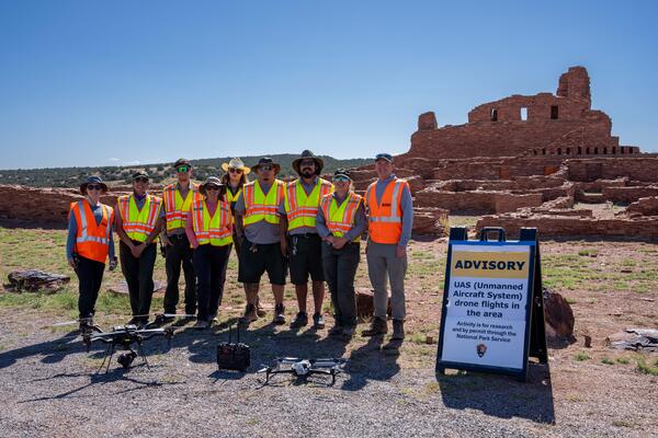
Mapping the Abó Ruins
U.S. Geological Survey and National Park Service personnel stand with drone technologies used for mapping the Abó Ruins at Salinas Pueblo Missions National Monument in Mountainair, New Mexico.
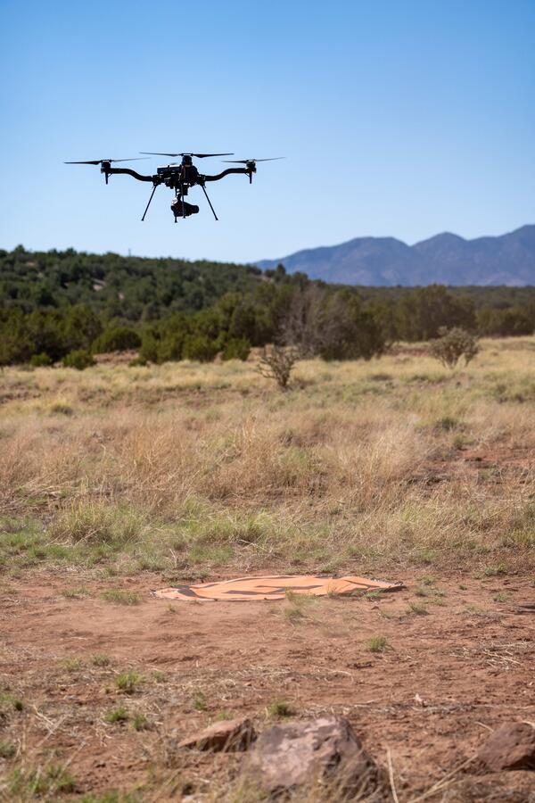
Using uncrewed aircraft systems (UAS) to map Abó Ruins
Using uncrewed aircraft systems (UAS) to map Abó RuinsThe U.S. Geological Survey National Uncrewed Systems Office flew uncrewed aircraft systems (UAS) to map the Abó Ruins at Salinas Pueblo Missions National Monument in Mountainair, New Mexico.
Using uncrewed aircraft systems (UAS) to map Abó Ruins
Using uncrewed aircraft systems (UAS) to map Abó RuinsThe U.S. Geological Survey National Uncrewed Systems Office flew uncrewed aircraft systems (UAS) to map the Abó Ruins at Salinas Pueblo Missions National Monument in Mountainair, New Mexico.
Lidar point cloud both with and without vegetation-classified points
Lidar point cloud both with and without vegetation-classified pointsIn 2024, the U.S. Geological Survey (USGS) National Uncrewed Systems Office (NUSO) provided technical support to the National Park Service in assessing road damage and landslide hazards along the Blue Ridge Parkway following Hurricane Helene.

Bare-earth digital terrain model of landslide damaged road
Bare-earth digital terrain model of landslide damaged roadIn 2024, the U.S. Geological Survey (USGS) National Uncrewed Systems Office (NUSO) provided technical support to the National Park Service in assessing road damage and landslide hazards along the Blue Ridge Parkway following Hurricane Helene.

Lidar point cloud with vegetation-classified points
Lidar point cloud with vegetation-classified pointsIn 2024, the U.S. Geological Survey (USGS) National Uncrewed Systems Office (NUSO) provided technical support to the National Park Service in assessing road damage and landslide hazards along the Blue Ridge Parkway following Hurricane Helene.

Point cloud image of landslide
In 2024, the U.S. Geological Survey (USGS) National Uncrewed Systems Office (NUSO) provided technical support for the National Park Service to assess road damage and landslide hazards after Hurricane Helene along the Blue Ridge Parkway.
In 2024, the U.S. Geological Survey (USGS) National Uncrewed Systems Office (NUSO) provided technical support for the National Park Service to assess road damage and landslide hazards after Hurricane Helene along the Blue Ridge Parkway.

Bare-earth digital terrain model of road damaged by landslide
Bare-earth digital terrain model of road damaged by landslideIn 2024, the U.S. Geological Survey (USGS) National Uncrewed Systems Office (NUSO) provided technical support for the National Park Service in assessing road damage and landslide hazards along the Blue Ridge Parkway following Hurricane Helene.

Lidar point cloud without vegetation-classified points
Lidar point cloud without vegetation-classified pointsIn 2024, the U.S. Geological Survey (USGS) National Uncrewed Systems Office (NUSO) provided technical support to the National Park Service in assessing road damage and landslide hazards along the Blue Ridge Parkway following Hurricane Helene.
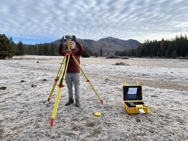
Setting up Global Navigation Satellite System (GNSS) base station in Yosemite
Setting up Global Navigation Satellite System (GNSS) base station in YosemiteUSGS geographer and remote pilot Mark Bauer sets up a Global Navigation Satellite System (GNSS) base station, which will be used to correct uncrewed aircraft system (UAS) lidar data during post-processing. It's early during the field day and a layer of frost covers the ground.

Mark 1.png
Mark Bauer, USGS Geographer. A photo shows USGS scientist Mark Bauer smiling at the camera. Mark is kneeling and holding the USGS drone with both hands. Mark wears a ballcap and an orange vest over his green USGS T-shirt. Behind Mark is a field of brown grass and a leaf-less tree sits in the background.
Mark Bauer, USGS Geographer. A photo shows USGS scientist Mark Bauer smiling at the camera. Mark is kneeling and holding the USGS drone with both hands. Mark wears a ballcap and an orange vest over his green USGS T-shirt. Behind Mark is a field of brown grass and a leaf-less tree sits in the background.

Mark 2.png
Mark communicates with the ground team (including Evan and Andy) to let them know that the USGS UAS is starting its flight over the snowpack.
Mark communicates with the ground team (including Evan and Andy) to let them know that the USGS UAS is starting its flight over the snowpack.

Mark 4.png
Mark Bauer, USGS Geographer. This graphic shows a quote from Mark’s narrative. It reads: “The program continued to grow, and as a remote pilot and geospatial analyst, I grew along with it.“ Yellow quotation marks bookend her quote.
Mark Bauer, USGS Geographer. This graphic shows a quote from Mark’s narrative. It reads: “The program continued to grow, and as a remote pilot and geospatial analyst, I grew along with it.“ Yellow quotation marks bookend her quote.

Mark 3.png
Mark checks the spatial data downloaded from the drone to make sure that the first UAS flight accurately collected snowpack data.
Mark checks the spatial data downloaded from the drone to make sure that the first UAS flight accurately collected snowpack data.
Science and Products
National Uncrewed Systems Office
The U.S. Geological Survey (USGS) National Uncrewed Systems Office (NUSO) leads the research activities needed to make Uncrewed Aircraft Systems (UAS) data collection an efficient, safe, and cost-effective remote sensing tool for Department of the Interior (DOI) and USGS scientists.
Mapping the Abó Ruins
U.S. Geological Survey and National Park Service personnel stand with drone technologies used for mapping the Abó Ruins at Salinas Pueblo Missions National Monument in Mountainair, New Mexico.
U.S. Geological Survey and National Park Service personnel stand with drone technologies used for mapping the Abó Ruins at Salinas Pueblo Missions National Monument in Mountainair, New Mexico.
Using uncrewed aircraft systems (UAS) to map Abó Ruins
Using uncrewed aircraft systems (UAS) to map Abó RuinsThe U.S. Geological Survey National Uncrewed Systems Office flew uncrewed aircraft systems (UAS) to map the Abó Ruins at Salinas Pueblo Missions National Monument in Mountainair, New Mexico.
Using uncrewed aircraft systems (UAS) to map Abó Ruins
Using uncrewed aircraft systems (UAS) to map Abó RuinsThe U.S. Geological Survey National Uncrewed Systems Office flew uncrewed aircraft systems (UAS) to map the Abó Ruins at Salinas Pueblo Missions National Monument in Mountainair, New Mexico.
Lidar point cloud both with and without vegetation-classified points
Lidar point cloud both with and without vegetation-classified pointsIn 2024, the U.S. Geological Survey (USGS) National Uncrewed Systems Office (NUSO) provided technical support to the National Park Service in assessing road damage and landslide hazards along the Blue Ridge Parkway following Hurricane Helene.
Bare-earth digital terrain model of landslide damaged road
Bare-earth digital terrain model of landslide damaged roadIn 2024, the U.S. Geological Survey (USGS) National Uncrewed Systems Office (NUSO) provided technical support to the National Park Service in assessing road damage and landslide hazards along the Blue Ridge Parkway following Hurricane Helene.
Lidar point cloud with vegetation-classified points
Lidar point cloud with vegetation-classified pointsIn 2024, the U.S. Geological Survey (USGS) National Uncrewed Systems Office (NUSO) provided technical support to the National Park Service in assessing road damage and landslide hazards along the Blue Ridge Parkway following Hurricane Helene.
Point cloud image of landslide
In 2024, the U.S. Geological Survey (USGS) National Uncrewed Systems Office (NUSO) provided technical support for the National Park Service to assess road damage and landslide hazards after Hurricane Helene along the Blue Ridge Parkway.
In 2024, the U.S. Geological Survey (USGS) National Uncrewed Systems Office (NUSO) provided technical support for the National Park Service to assess road damage and landslide hazards after Hurricane Helene along the Blue Ridge Parkway.
Bare-earth digital terrain model of road damaged by landslide
Bare-earth digital terrain model of road damaged by landslideIn 2024, the U.S. Geological Survey (USGS) National Uncrewed Systems Office (NUSO) provided technical support for the National Park Service in assessing road damage and landslide hazards along the Blue Ridge Parkway following Hurricane Helene.
Lidar point cloud without vegetation-classified points
Lidar point cloud without vegetation-classified pointsIn 2024, the U.S. Geological Survey (USGS) National Uncrewed Systems Office (NUSO) provided technical support to the National Park Service in assessing road damage and landslide hazards along the Blue Ridge Parkway following Hurricane Helene.
Setting up Global Navigation Satellite System (GNSS) base station in Yosemite
Setting up Global Navigation Satellite System (GNSS) base station in YosemiteUSGS geographer and remote pilot Mark Bauer sets up a Global Navigation Satellite System (GNSS) base station, which will be used to correct uncrewed aircraft system (UAS) lidar data during post-processing. It's early during the field day and a layer of frost covers the ground.
Mark 1.png
Mark Bauer, USGS Geographer. A photo shows USGS scientist Mark Bauer smiling at the camera. Mark is kneeling and holding the USGS drone with both hands. Mark wears a ballcap and an orange vest over his green USGS T-shirt. Behind Mark is a field of brown grass and a leaf-less tree sits in the background.
Mark Bauer, USGS Geographer. A photo shows USGS scientist Mark Bauer smiling at the camera. Mark is kneeling and holding the USGS drone with both hands. Mark wears a ballcap and an orange vest over his green USGS T-shirt. Behind Mark is a field of brown grass and a leaf-less tree sits in the background.
Mark 2.png
Mark communicates with the ground team (including Evan and Andy) to let them know that the USGS UAS is starting its flight over the snowpack.
Mark communicates with the ground team (including Evan and Andy) to let them know that the USGS UAS is starting its flight over the snowpack.
Mark 4.png
Mark Bauer, USGS Geographer. This graphic shows a quote from Mark’s narrative. It reads: “The program continued to grow, and as a remote pilot and geospatial analyst, I grew along with it.“ Yellow quotation marks bookend her quote.
Mark Bauer, USGS Geographer. This graphic shows a quote from Mark’s narrative. It reads: “The program continued to grow, and as a remote pilot and geospatial analyst, I grew along with it.“ Yellow quotation marks bookend her quote.
Mark 3.png
Mark checks the spatial data downloaded from the drone to make sure that the first UAS flight accurately collected snowpack data.
Mark checks the spatial data downloaded from the drone to make sure that the first UAS flight accurately collected snowpack data.