Logo in support of the 7th Federal UxS Users Workshop to be hosted March 3-5, 2026
Matt A Burgess
Matt Burgess is a Geographer at the National Uncrewed Systems Office (NUSO) in the Geosciences and Environmental Change Science Center.
Science and Products
7th Federal UxS Workshop
National Uncrewed Systems Office
Geospatial data for impounded sediments in Pahranagat Wash above Arrow Canyon Dam, in northern Moapa Valley, Nevada Geospatial data for impounded sediments in Pahranagat Wash above Arrow Canyon Dam, in northern Moapa Valley, Nevada
2023 ECCOE UAS Multispectral and Hyperspectral Imagery Radiometric Calibration Evaluation Field Data 2023 ECCOE UAS Multispectral and Hyperspectral Imagery Radiometric Calibration Evaluation Field Data
Lidar point cloud, raster, and RTK GNSS survey data for pre- and post-restoration of Ackerson Meadows, Yosemite National Park, California, USA Lidar point cloud, raster, and RTK GNSS survey data for pre- and post-restoration of Ackerson Meadows, Yosemite National Park, California, USA
Uncrewed Aircraft System (UAS) imagery and data products from a multiscale remote sensing field campaign at a biocrust monitoring site located near Castle Valley, Utah in February 2022 Uncrewed Aircraft System (UAS) imagery and data products from a multiscale remote sensing field campaign at a biocrust monitoring site located near Castle Valley, Utah in February 2022
UAS lidar Digital Terrain Model of a southern subset in Palo Alto Battlefield National Historic Park, Texas, March 2024 UAS lidar Digital Terrain Model of a southern subset in Palo Alto Battlefield National Historic Park, Texas, March 2024
Lidar and photogrammetry point clouds with supporting imagery and GPS information collected during UAS operations at Great Sippewissett Marsh, Cape Cod, Massachusetts in Fall 2022 Lidar and photogrammetry point clouds with supporting imagery and GPS information collected during UAS operations at Great Sippewissett Marsh, Cape Cod, Massachusetts in Fall 2022
Uncrewed Aircraft Systems (UAS) natural color imagery and structure-from-motion data products collected at the Marsh-Felch Dinosaur Quarry site in Colorado, July 2024 Uncrewed Aircraft Systems (UAS) natural color imagery and structure-from-motion data products collected at the Marsh-Felch Dinosaur Quarry site in Colorado, July 2024
Hyperspectral image transects and field measurements of reflectance, visible dye concentration, and flow velocity acquired during a tracer experiment on the Missouri River near Lexington, MO, on May 11, 2024 Hyperspectral image transects and field measurements of reflectance, visible dye concentration, and flow velocity acquired during a tracer experiment on the Missouri River near Lexington, MO, on May 11, 2024
Uncrewed Aircraft Systems (UAS) natural color, multispectral, lidar, and hyperspectral remote sensing data products collected at dryland sites 40 km south of Moab, Utah in May 2023 Uncrewed Aircraft Systems (UAS) natural color, multispectral, lidar, and hyperspectral remote sensing data products collected at dryland sites 40 km south of Moab, Utah in May 2023
Lidar Point Clouds (LPCs), Digital Elevation Models (DEMs), and Snow Depth Raster Maps Derived from Lidar Data Collected on Small, Uncrewed Aircraft Systems in the Upper Colorado River Basin, Colorado, 2020-22 Lidar Point Clouds (LPCs), Digital Elevation Models (DEMs), and Snow Depth Raster Maps Derived from Lidar Data Collected on Small, Uncrewed Aircraft Systems in the Upper Colorado River Basin, Colorado, 2020-22
Colorado River at Windy Gap near Granby, CO - 2021/07/27 Water Surface Velocity Map Using Particle Image Velocimetry Colorado River at Windy Gap near Granby, CO - 2021/07/27 Water Surface Velocity Map Using Particle Image Velocimetry
Logo in support of the 7th Federal UxS Users Workshop to be hosted March 3-5, 2026
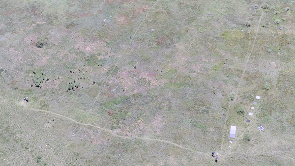
 Aerial photo looking down at a field with drone operator and reference objects used for calibration of payload instruments
B-Roll: 2025 UAS radiometric calibration and validation research in Golden, Colorado
B-Roll: 2025 UAS radiometric calibration and validation research in Golden, ColoradoCalibration and validation (cal/val) are essential steps to ensure that remotely sensed data are reliable for scientific use. Radiometric cal/val involves converting digital image pixel values to meaningful units and assessing their accuracy.

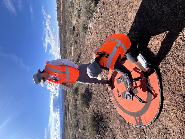
Setting up equipment for drone mapping flight near Moab, Utah
Setting up equipment for drone mapping flight near Moab, UtahUSGS remote pilots Matt Burgess and Victoria Scholl prepare to conduct a drone mapping flight to collect thermal imagery over a dryland study site near Moab, Utah.
Setting up equipment for drone mapping flight near Moab, Utah
Setting up equipment for drone mapping flight near Moab, UtahUSGS remote pilots Matt Burgess and Victoria Scholl prepare to conduct a drone mapping flight to collect thermal imagery over a dryland study site near Moab, Utah.
The U.S. Geological Survey (USGS) employs a range of drone technologies for data collection in science, mapping, and monitoring.
The U.S. Geological Survey (USGS) employs a range of drone technologies for data collection in science, mapping, and monitoring.
The Blue Ridge Parkway is renowned for its winding path through the rugged Appalachian Mountains. The steep terrain and dense forests make for scenic views but also create a challenging environment for drone operations. U.S. Geological Survey (USGS) remote pilots seek out open areas from which to conduct flights to enable good visibility of their surroundings.
The Blue Ridge Parkway is renowned for its winding path through the rugged Appalachian Mountains. The steep terrain and dense forests make for scenic views but also create a challenging environment for drone operations. U.S. Geological Survey (USGS) remote pilots seek out open areas from which to conduct flights to enable good visibility of their surroundings.

Uncrewed aircraft pilots at the Tanbark Ridge Overlook
Uncrewed aircraft pilots at the Tanbark Ridge OverlookU.S. Geological Survey (USGS) remote pilots Joe Adams and Matthew Burgess prepare to conduct drone flights at the Tanbark Ridge Overlook along the Blue Ridge Parkway in North Carolina.
Uncrewed aircraft pilots at the Tanbark Ridge Overlook
Uncrewed aircraft pilots at the Tanbark Ridge OverlookU.S. Geological Survey (USGS) remote pilots Joe Adams and Matthew Burgess prepare to conduct drone flights at the Tanbark Ridge Overlook along the Blue Ridge Parkway in North Carolina.
In September 2024, Hurricane Helene brought heavy rain and powerful winds, resulting in multiple landslides along the iconic Blue Ridge Parkway. The National Park Service requested technical assistance from the U.S.
In September 2024, Hurricane Helene brought heavy rain and powerful winds, resulting in multiple landslides along the iconic Blue Ridge Parkway. The National Park Service requested technical assistance from the U.S.
In September 2024, Hurricane Helene brought heavy rain and powerful winds, resulting in multiple landslides along the iconic Blue Ridge Parkway. The National Park Service requested technical assistance from the U.S.
In September 2024, Hurricane Helene brought heavy rain and powerful winds, resulting in multiple landslides along the iconic Blue Ridge Parkway. The National Park Service requested technical assistance from the U.S.

Attendees of the 6th Federal Uncrewed Systems (UxS) Users Workshop
Attendees of the 6th Federal Uncrewed Systems (UxS) Users WorkshopAerial photo of attendees at the 6th Federal Uncrewed Systems (UxS) Workshop taken from a Skydio drone in front of the Science and Technology building at the Southwestern Indian Polytechnic Institute, Albuquerque, New Mexico.
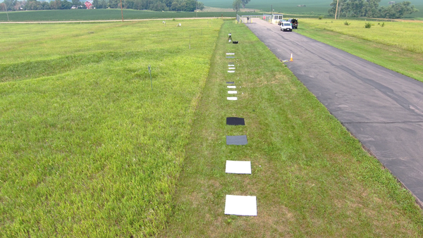
 Square, colored reference targets spaced in the grass along roadside
UAS Radiometric Calibration Research in South Dakota, July 2023
UAS Radiometric Calibration Research in South Dakota, July 2023In July 2023, the U.S. Geological Survey (USGS) National Uncrewed Systems Office (NUSO) and the USGS Earth Resources Observation and Science (EROS) Center conducted a joint field campaign in Sioux Falls, South Dakota.
In this photo, a group of 20 scientists pose for the camera. The group is dressed in winter gear and stands in front of Berthoud Pass, Colorado. The pass and the ground are covered in snow. Berthoud Pass has a few patches of dark green trees.
In this photo, a group of 20 scientists pose for the camera. The group is dressed in winter gear and stands in front of Berthoud Pass, Colorado. The pass and the ground are covered in snow. Berthoud Pass has a few patches of dark green trees.
The Snow to Flow team is comprised of a “village” of remarkable scientists and engineers from the USGS Colorado Water Science Center, USGS National Uncrewed Systems Office (NUSO), and the University of Southern California - Viterbi School of Engineering. The team is pictured here at the Berthoud Pass, CO field site on April 18, 2022.
The Snow to Flow team is comprised of a “village” of remarkable scientists and engineers from the USGS Colorado Water Science Center, USGS National Uncrewed Systems Office (NUSO), and the University of Southern California - Viterbi School of Engineering. The team is pictured here at the Berthoud Pass, CO field site on April 18, 2022.
Absolute radiometric calibration evaluation of Uncrewed Aerial System (UAS) Headwall and MicaSense sensors and improving data quality using the Empirical Line Method Absolute radiometric calibration evaluation of Uncrewed Aerial System (UAS) Headwall and MicaSense sensors and improving data quality using the Empirical Line Method
Drone-based radiometric surveys provide high-resolution mine waste characterization Drone-based radiometric surveys provide high-resolution mine waste characterization
The tortoise and the antilocaprid: Adapting GPS tracking and terrain data to model wildlife walking functions The tortoise and the antilocaprid: Adapting GPS tracking and terrain data to model wildlife walking functions
Applications of unoccupied aerial systems (UAS) in landscape ecology: A review of recent research, challenges and emerging opportunities Applications of unoccupied aerial systems (UAS) in landscape ecology: A review of recent research, challenges and emerging opportunities
Hyperspectral Image Transects during Transient Events in Rivers (HITTER): Framework development and application to a tracer experiment on the Missouri River, USA Hyperspectral Image Transects during Transient Events in Rivers (HITTER): Framework development and application to a tracer experiment on the Missouri River, USA
Ongoing (2015-) magma surge in the upper mantle beneath the Island of Hawaiʻi Ongoing (2015-) magma surge in the upper mantle beneath the Island of Hawaiʻi
Positional accuracy assessment of lidar point cloud from NAIP/3DEP pilot project Positional accuracy assessment of lidar point cloud from NAIP/3DEP pilot project
The 2018 rift eruption and summit collapse of Kilauea Volcano The 2018 rift eruption and summit collapse of Kilauea Volcano
Water-resources and land-surface deformation evaluation studies at Fort Irwin National Training Center, Mojave Desert, California Water-resources and land-surface deformation evaluation studies at Fort Irwin National Training Center, Mojave Desert, California
Electrical resistivity investigation of fluvial geomorphology to evaluate potential seepage conduits to agricultural lands along the San Joaquin River, Merced County, California, 2012–13 Electrical resistivity investigation of fluvial geomorphology to evaluate potential seepage conduits to agricultural lands along the San Joaquin River, Merced County, California, 2012–13
Selected techniques for monitoring water movement through unsaturated alluvium during managed aquifer recharge Selected techniques for monitoring water movement through unsaturated alluvium during managed aquifer recharge
The 2014 annual report for the Hawaiian Volcano Observatory The 2014 annual report for the Hawaiian Volcano Observatory
Science and Products
7th Federal UxS Workshop
National Uncrewed Systems Office
Geospatial data for impounded sediments in Pahranagat Wash above Arrow Canyon Dam, in northern Moapa Valley, Nevada Geospatial data for impounded sediments in Pahranagat Wash above Arrow Canyon Dam, in northern Moapa Valley, Nevada
2023 ECCOE UAS Multispectral and Hyperspectral Imagery Radiometric Calibration Evaluation Field Data 2023 ECCOE UAS Multispectral and Hyperspectral Imagery Radiometric Calibration Evaluation Field Data
Lidar point cloud, raster, and RTK GNSS survey data for pre- and post-restoration of Ackerson Meadows, Yosemite National Park, California, USA Lidar point cloud, raster, and RTK GNSS survey data for pre- and post-restoration of Ackerson Meadows, Yosemite National Park, California, USA
Uncrewed Aircraft System (UAS) imagery and data products from a multiscale remote sensing field campaign at a biocrust monitoring site located near Castle Valley, Utah in February 2022 Uncrewed Aircraft System (UAS) imagery and data products from a multiscale remote sensing field campaign at a biocrust monitoring site located near Castle Valley, Utah in February 2022
UAS lidar Digital Terrain Model of a southern subset in Palo Alto Battlefield National Historic Park, Texas, March 2024 UAS lidar Digital Terrain Model of a southern subset in Palo Alto Battlefield National Historic Park, Texas, March 2024
Lidar and photogrammetry point clouds with supporting imagery and GPS information collected during UAS operations at Great Sippewissett Marsh, Cape Cod, Massachusetts in Fall 2022 Lidar and photogrammetry point clouds with supporting imagery and GPS information collected during UAS operations at Great Sippewissett Marsh, Cape Cod, Massachusetts in Fall 2022
Uncrewed Aircraft Systems (UAS) natural color imagery and structure-from-motion data products collected at the Marsh-Felch Dinosaur Quarry site in Colorado, July 2024 Uncrewed Aircraft Systems (UAS) natural color imagery and structure-from-motion data products collected at the Marsh-Felch Dinosaur Quarry site in Colorado, July 2024
Hyperspectral image transects and field measurements of reflectance, visible dye concentration, and flow velocity acquired during a tracer experiment on the Missouri River near Lexington, MO, on May 11, 2024 Hyperspectral image transects and field measurements of reflectance, visible dye concentration, and flow velocity acquired during a tracer experiment on the Missouri River near Lexington, MO, on May 11, 2024
Uncrewed Aircraft Systems (UAS) natural color, multispectral, lidar, and hyperspectral remote sensing data products collected at dryland sites 40 km south of Moab, Utah in May 2023 Uncrewed Aircraft Systems (UAS) natural color, multispectral, lidar, and hyperspectral remote sensing data products collected at dryland sites 40 km south of Moab, Utah in May 2023
Lidar Point Clouds (LPCs), Digital Elevation Models (DEMs), and Snow Depth Raster Maps Derived from Lidar Data Collected on Small, Uncrewed Aircraft Systems in the Upper Colorado River Basin, Colorado, 2020-22 Lidar Point Clouds (LPCs), Digital Elevation Models (DEMs), and Snow Depth Raster Maps Derived from Lidar Data Collected on Small, Uncrewed Aircraft Systems in the Upper Colorado River Basin, Colorado, 2020-22
Colorado River at Windy Gap near Granby, CO - 2021/07/27 Water Surface Velocity Map Using Particle Image Velocimetry Colorado River at Windy Gap near Granby, CO - 2021/07/27 Water Surface Velocity Map Using Particle Image Velocimetry
Logo in support of the 7th Federal UxS Users Workshop to be hosted March 3-5, 2026
Logo in support of the 7th Federal UxS Users Workshop to be hosted March 3-5, 2026
 Aerial photo looking down at a field with drone operator and reference objects used for calibration of payload instruments
B-Roll: 2025 UAS radiometric calibration and validation research in Golden, Colorado
B-Roll: 2025 UAS radiometric calibration and validation research in Golden, ColoradoCalibration and validation (cal/val) are essential steps to ensure that remotely sensed data are reliable for scientific use. Radiometric cal/val involves converting digital image pixel values to meaningful units and assessing their accuracy.
B-Roll: 2025 UAS radiometric calibration and validation research in Golden, Colorado
B-Roll: 2025 UAS radiometric calibration and validation research in Golden, ColoradoCalibration and validation (cal/val) are essential steps to ensure that remotely sensed data are reliable for scientific use. Radiometric cal/val involves converting digital image pixel values to meaningful units and assessing their accuracy.

Setting up equipment for drone mapping flight near Moab, Utah
Setting up equipment for drone mapping flight near Moab, UtahUSGS remote pilots Matt Burgess and Victoria Scholl prepare to conduct a drone mapping flight to collect thermal imagery over a dryland study site near Moab, Utah.
Setting up equipment for drone mapping flight near Moab, Utah
Setting up equipment for drone mapping flight near Moab, UtahUSGS remote pilots Matt Burgess and Victoria Scholl prepare to conduct a drone mapping flight to collect thermal imagery over a dryland study site near Moab, Utah.
The U.S. Geological Survey (USGS) employs a range of drone technologies for data collection in science, mapping, and monitoring.
The U.S. Geological Survey (USGS) employs a range of drone technologies for data collection in science, mapping, and monitoring.
The Blue Ridge Parkway is renowned for its winding path through the rugged Appalachian Mountains. The steep terrain and dense forests make for scenic views but also create a challenging environment for drone operations. U.S. Geological Survey (USGS) remote pilots seek out open areas from which to conduct flights to enable good visibility of their surroundings.
The Blue Ridge Parkway is renowned for its winding path through the rugged Appalachian Mountains. The steep terrain and dense forests make for scenic views but also create a challenging environment for drone operations. U.S. Geological Survey (USGS) remote pilots seek out open areas from which to conduct flights to enable good visibility of their surroundings.

Uncrewed aircraft pilots at the Tanbark Ridge Overlook
Uncrewed aircraft pilots at the Tanbark Ridge OverlookU.S. Geological Survey (USGS) remote pilots Joe Adams and Matthew Burgess prepare to conduct drone flights at the Tanbark Ridge Overlook along the Blue Ridge Parkway in North Carolina.
Uncrewed aircraft pilots at the Tanbark Ridge Overlook
Uncrewed aircraft pilots at the Tanbark Ridge OverlookU.S. Geological Survey (USGS) remote pilots Joe Adams and Matthew Burgess prepare to conduct drone flights at the Tanbark Ridge Overlook along the Blue Ridge Parkway in North Carolina.
In September 2024, Hurricane Helene brought heavy rain and powerful winds, resulting in multiple landslides along the iconic Blue Ridge Parkway. The National Park Service requested technical assistance from the U.S.
In September 2024, Hurricane Helene brought heavy rain and powerful winds, resulting in multiple landslides along the iconic Blue Ridge Parkway. The National Park Service requested technical assistance from the U.S.
In September 2024, Hurricane Helene brought heavy rain and powerful winds, resulting in multiple landslides along the iconic Blue Ridge Parkway. The National Park Service requested technical assistance from the U.S.
In September 2024, Hurricane Helene brought heavy rain and powerful winds, resulting in multiple landslides along the iconic Blue Ridge Parkway. The National Park Service requested technical assistance from the U.S.

Attendees of the 6th Federal Uncrewed Systems (UxS) Users Workshop
Attendees of the 6th Federal Uncrewed Systems (UxS) Users WorkshopAerial photo of attendees at the 6th Federal Uncrewed Systems (UxS) Workshop taken from a Skydio drone in front of the Science and Technology building at the Southwestern Indian Polytechnic Institute, Albuquerque, New Mexico.
Attendees of the 6th Federal Uncrewed Systems (UxS) Users Workshop
Attendees of the 6th Federal Uncrewed Systems (UxS) Users WorkshopAerial photo of attendees at the 6th Federal Uncrewed Systems (UxS) Workshop taken from a Skydio drone in front of the Science and Technology building at the Southwestern Indian Polytechnic Institute, Albuquerque, New Mexico.
 Square, colored reference targets spaced in the grass along roadside
UAS Radiometric Calibration Research in South Dakota, July 2023
UAS Radiometric Calibration Research in South Dakota, July 2023In July 2023, the U.S. Geological Survey (USGS) National Uncrewed Systems Office (NUSO) and the USGS Earth Resources Observation and Science (EROS) Center conducted a joint field campaign in Sioux Falls, South Dakota.
UAS Radiometric Calibration Research in South Dakota, July 2023
UAS Radiometric Calibration Research in South Dakota, July 2023In July 2023, the U.S. Geological Survey (USGS) National Uncrewed Systems Office (NUSO) and the USGS Earth Resources Observation and Science (EROS) Center conducted a joint field campaign in Sioux Falls, South Dakota.
In this photo, a group of 20 scientists pose for the camera. The group is dressed in winter gear and stands in front of Berthoud Pass, Colorado. The pass and the ground are covered in snow. Berthoud Pass has a few patches of dark green trees.
In this photo, a group of 20 scientists pose for the camera. The group is dressed in winter gear and stands in front of Berthoud Pass, Colorado. The pass and the ground are covered in snow. Berthoud Pass has a few patches of dark green trees.
The Snow to Flow team is comprised of a “village” of remarkable scientists and engineers from the USGS Colorado Water Science Center, USGS National Uncrewed Systems Office (NUSO), and the University of Southern California - Viterbi School of Engineering. The team is pictured here at the Berthoud Pass, CO field site on April 18, 2022.
The Snow to Flow team is comprised of a “village” of remarkable scientists and engineers from the USGS Colorado Water Science Center, USGS National Uncrewed Systems Office (NUSO), and the University of Southern California - Viterbi School of Engineering. The team is pictured here at the Berthoud Pass, CO field site on April 18, 2022.


