
Continuous water quality monitor that is deployed off a bridge in Westerly RI, just upstream of the 01118500 gage.
Images
Images intro.
Filter Total Items: 43

Continuous water quality monitor
Continuous water quality monitor that is deployed off a bridge in Westerly RI, just upstream of the 01118500 gage.

Groundwater measurement
Hydrologic technician performing an electric tape down measurement of a real-time groundwater well. The site ID is: 412154071462901 RI-WEW 522 in Westerly, Rhode Island.
Hydrologic technician performing an electric tape down measurement of a real-time groundwater well. The site ID is: 412154071462901 RI-WEW 522 in Westerly, Rhode Island.

Well CHW 18, Ninigret Park, Charlestown, Rhode Island
Well CHW 18, Ninigret Park, Charlestown, Rhode IslandPhoto of the Well CHW 18, Ninigret Park, Charlestown, Rhode Island. The depth of the well is 32.0 feet below land surface.
Well CHW 18, Ninigret Park, Charlestown, Rhode Island
Well CHW 18, Ninigret Park, Charlestown, Rhode IslandPhoto of the Well CHW 18, Ninigret Park, Charlestown, Rhode Island. The depth of the well is 32.0 feet below land surface.

National Oil and Gas Assessment Provinces
This is a graphic from the USGS National Oil and Gas Assessment Explorer application, which allows user to drill into 70 oil and gas assessment provinces throughout the United States.
This is a graphic from the USGS National Oil and Gas Assessment Explorer application, which allows user to drill into 70 oil and gas assessment provinces throughout the United States.

Sakonnet River, the eastern arm of the Narragansett Bay, Rhode Island
Sakonnet River, the eastern arm of the Narragansett Bay, Rhode IslandView of the Sakonnet River, the eastern arm of the Narragansett Bay, Rhode Island.
Sakonnet River, the eastern arm of the Narragansett Bay, Rhode Island
Sakonnet River, the eastern arm of the Narragansett Bay, Rhode IslandView of the Sakonnet River, the eastern arm of the Narragansett Bay, Rhode Island.

Rhode Island Landsat State Mosaic
The total area (land and water) of Rhode Island is only 1,545 square miles. The state measures about 37 miles east-west, and about 48 miles north-south.
Capital Providence
Image Source Landsat 8
Population 1,097,379
Number of Pixels 3,162,631
The total area (land and water) of Rhode Island is only 1,545 square miles. The state measures about 37 miles east-west, and about 48 miles north-south.
Capital Providence
Image Source Landsat 8
Population 1,097,379
Number of Pixels 3,162,631

Streamgage 01115110 in Rhode Island
Photograph of monitoring station at U.S. Geological Survey streamgage 01115110, Huntinghouse Brook at Elmdale Road near North Scituate, Rhode Island.
Photograph of monitoring station at U.S. Geological Survey streamgage 01115110, Huntinghouse Brook at Elmdale Road near North Scituate, Rhode Island.

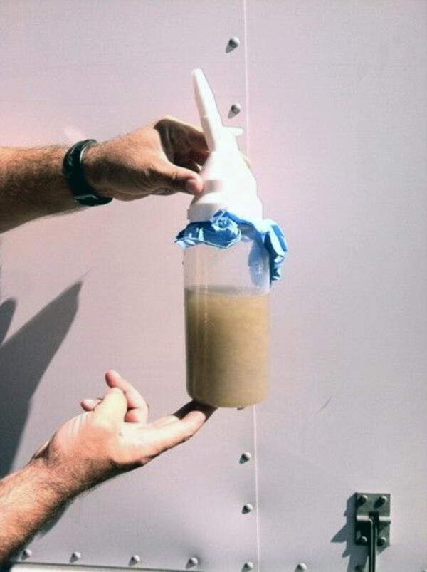
Sampling system used to collect composite samples of stormflow
Sampling system used to collect composite samples of stormflowPhotograph of the sampling system used to collect flow-proportional filtered and nonfiltered composite samples of stormflow at the 01115110, Huntinghouse Brook at Elmdale Road near North Scituate, Rhode Island, streamgage.

Landsat image of the Providence Area
Landsat image of the area near Providence, Rhode Island. This natural color Landsat composite was created using the red, green and blue bands.
Learn more about the Landsat program
Landsat image of the area near Providence, Rhode Island. This natural color Landsat composite was created using the red, green and blue bands.
Learn more about the Landsat program

Photo of the seafloor in Block Island Sound, Rhode Island
Photo of the seafloor in Block Island Sound, Rhode IslandPhoto of the seafloor in Block Island Sound showing a rock crab and several shrimp on a boulder that is covered with bryozoans. The photo was collected in support of research and management activities (e.g., wind farms and fisheries) along the Rhode Island inner continental shelf.

Elevation Surveying at High-Water Mark Location on Block Island
Elevation Surveying at High-Water Mark Location on Block IslandAfter Hurricane Sandy, USGS researchers survey elevation at the location of a wrack line, indicating a high-water level mark, on Block Island, Rhode Island.
Elevation Surveying at High-Water Mark Location on Block Island
Elevation Surveying at High-Water Mark Location on Block IslandAfter Hurricane Sandy, USGS researchers survey elevation at the location of a wrack line, indicating a high-water level mark, on Block Island, Rhode Island.

Rhode Island Beach Home Damaged by Hurricane Sandy
Rhode Island Beach Home Damaged by Hurricane SandyA coastal home damaged by Hurricane Sandy's historic storm surge on a beach in Rhode Island.
Rhode Island Beach Home Damaged by Hurricane Sandy
Rhode Island Beach Home Damaged by Hurricane SandyA coastal home damaged by Hurricane Sandy's historic storm surge on a beach in Rhode Island.

Rhode Island Beach Home Damaged by Hurricane Sandy
Rhode Island Beach Home Damaged by Hurricane SandyA coastal home damaged by Hurricane Sandy's historic storm surge on a beach in Rhode Island.
Rhode Island Beach Home Damaged by Hurricane Sandy
Rhode Island Beach Home Damaged by Hurricane SandyA coastal home damaged by Hurricane Sandy's historic storm surge on a beach in Rhode Island.

Rhode Island Beach Home Damaged by Hurricane Sandy
Rhode Island Beach Home Damaged by Hurricane SandyA coastal home damaged by Hurricane Sandy's historic storm surge on a beach in Rhode Island.
Rhode Island Beach Home Damaged by Hurricane Sandy
Rhode Island Beach Home Damaged by Hurricane SandyA coastal home damaged by Hurricane Sandy's historic storm surge on a beach in Rhode Island.
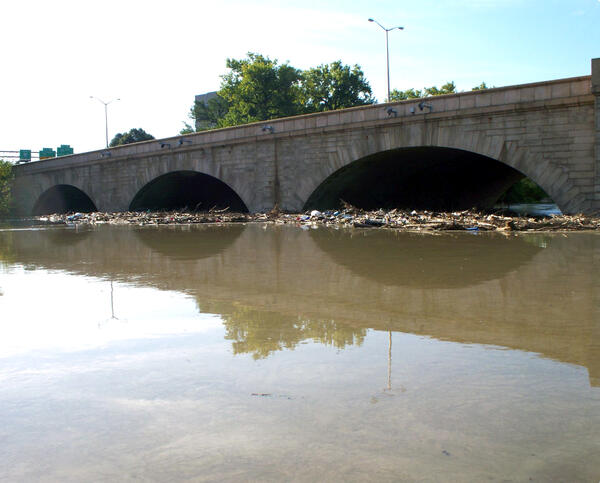
Debris jam from flooding after Tropical Strom Irene
Debris jam from flooding after Tropical Strom IreneDebris jam from flooding after Tropical Strom Irene on the upstream side of the Bulkeley Bridge in Hartford, CT.
Debris jam from flooding after Tropical Strom Irene
Debris jam from flooding after Tropical Strom IreneDebris jam from flooding after Tropical Strom Irene on the upstream side of the Bulkeley Bridge in Hartford, CT.
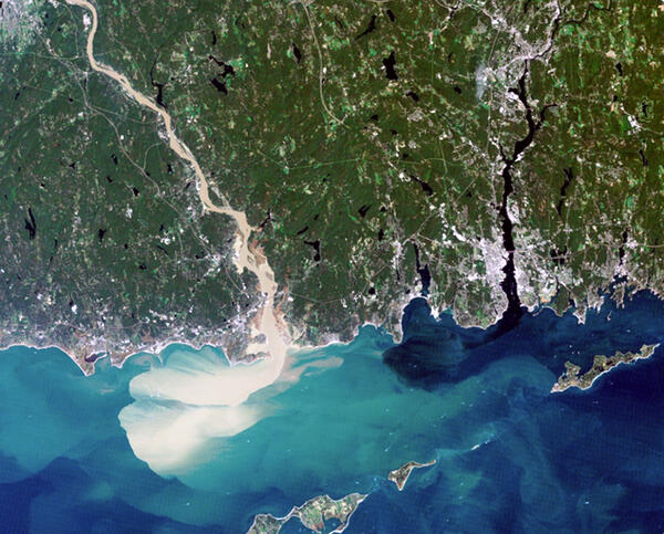
Satellite imagery showing the Connecticut River sediment
Satellite imagery showing the Connecticut River sedimentSatellite imagery of southern Connecticut showing the Connecticut River and the Thames River, with the Connecticut River a muddy color due to heavy sediment transport.
Satellite imagery showing the Connecticut River sediment
Satellite imagery showing the Connecticut River sedimentSatellite imagery of southern Connecticut showing the Connecticut River and the Thames River, with the Connecticut River a muddy color due to heavy sediment transport.
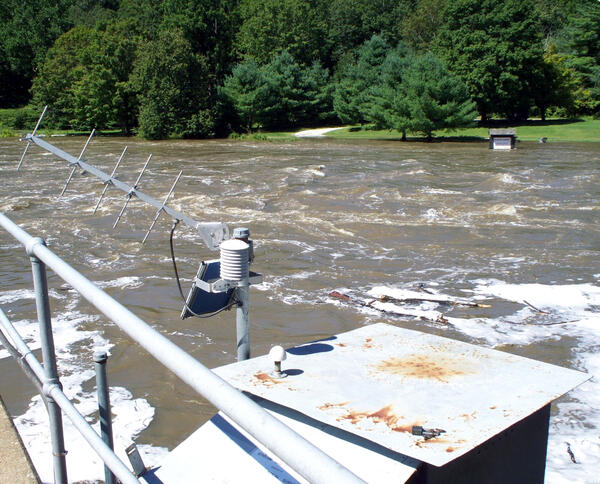
High water from Tropical Storm Irene
High water from Tropical Storm Irene at going past the Housatonic River at Falls Village, CT (01199000) streamgage, park and boat ramp on the far side of river is inundated by the flood water.
High water from Tropical Storm Irene at going past the Housatonic River at Falls Village, CT (01199000) streamgage, park and boat ramp on the far side of river is inundated by the flood water.
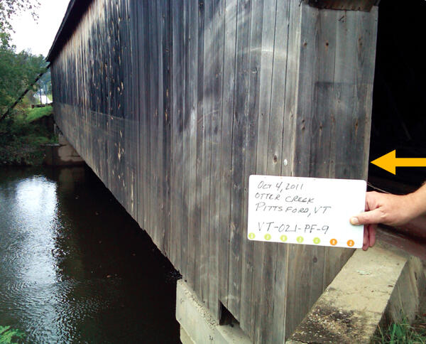
Covered bridge showing a high-water mark from Tropical Storm Irene
Covered bridge showing a high-water mark from Tropical Storm IreneCovered bridge over Otter Creek showing a high-water mark (silt line) from Tropical Storm Irene.
Covered bridge showing a high-water mark from Tropical Storm Irene
Covered bridge showing a high-water mark from Tropical Storm IreneCovered bridge over Otter Creek showing a high-water mark (silt line) from Tropical Storm Irene.
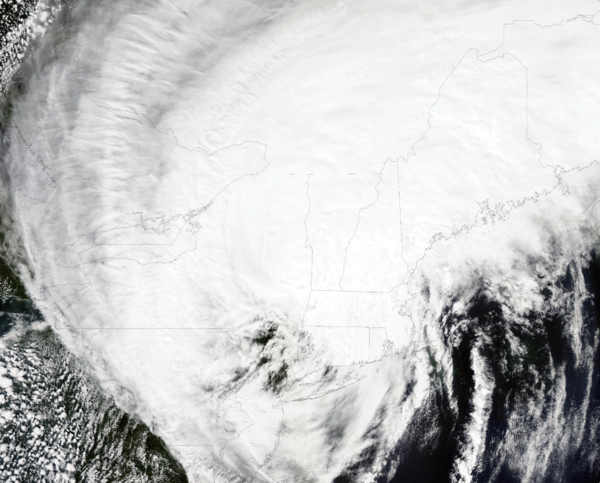
Satellite photo shows the center of Tropical Storm Irene passing over New England
Satellite photo shows the center of Tropical Storm Irene passing over New EnglandOn Aug. 28th, 2011, this image was collected by the Moderate Resolution Imaging Spectroradiometer (MODIS) on NASA’s Aqua Satellite and shows the center of Tropical Storm Irene passing over New England. State borders and coastlines are shown as black lines.
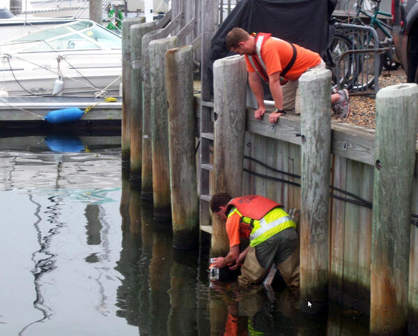
Water level sensor installation before Tropical Storm Irene
Water level sensor installation before Tropical Storm IreneHydrologic Technicians strapping a water level sensor to a retaining wall piling in preparation for the arrival of Tropical Storm Irene and its storm surge.
Water level sensor installation before Tropical Storm Irene
Water level sensor installation before Tropical Storm IreneHydrologic Technicians strapping a water level sensor to a retaining wall piling in preparation for the arrival of Tropical Storm Irene and its storm surge.