
Corner view of the federal building in Sacramento where the USGS Southwest Regional Office staff are located.
Multimedia
Photos, videos, audio files, and webcam photos described and linked on this webpage come from a wide variety of USGS science activities and presentations done by USGS Science Center staff members in the Region 8: Lower Colorado Basin. The "View All" link buttons at the bottom of the sections on this page lead to webpages containing links to additional multimedia files.
Images

Sacramento Federal Building on Cottage Way
Corner view of the federal building in Sacramento where the USGS Southwest Regional Office staff are located.

Region8_arcgis_bnd.grn8_.carousel.JPG
Interior Region 8 covers Arizona and portions of southern California and Nevada. The centers in the Region include: the Astrogeology Science Center (ASTRO); Earthquake Science Center (ESC); Geology, Energy, Minerals, and Geophysics Science Center (GMEG), Pacific Coastal and Marine Science Center (PCMSC), Southwest Biological Science Center (SBSC), and Water Sc
Interior Region 8 covers Arizona and portions of southern California and Nevada. The centers in the Region include: the Astrogeology Science Center (ASTRO); Earthquake Science Center (ESC); Geology, Energy, Minerals, and Geophysics Science Center (GMEG), Pacific Coastal and Marine Science Center (PCMSC), Southwest Biological Science Center (SBSC), and Water Sc
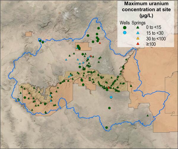
Map of Grand Canyon uranium concentrations as spring and well sites
Map of Grand Canyon uranium concentrations as spring and well sitesMap of maximum uranium concentration at 206 spring and well sites in the Grand Canyon region.
Map of Grand Canyon uranium concentrations as spring and well sites
Map of Grand Canyon uranium concentrations as spring and well sitesMap of maximum uranium concentration at 206 spring and well sites in the Grand Canyon region.
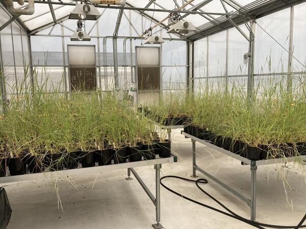
Greenhouse study comparing plant provenance for restoration
Greenhouse study comparing plant provenance for restorationRestoreNet is partnering with the Gornish lab at the University of Arizona to better understand how a plant’s source location (provenance) influences its performance in a restoration setting. This greenhouse experiment will be conducted by PhD student, Sierra Lauman.

Pre-construction monitoring of vegetation for the Gemini Solar Array
Pre-construction monitoring of vegetation for the Gemini Solar ArrayThe United States is developing renewable energy resources, especially solar, at a rapid rate.
Pre-construction monitoring of vegetation for the Gemini Solar Array
Pre-construction monitoring of vegetation for the Gemini Solar ArrayThe United States is developing renewable energy resources, especially solar, at a rapid rate.

Greenhouse study comparing plant performance during drought.
Greenhouse study comparing plant performance during drought.Greenhouse study comparing plant performance during drought will help land managers choose plant species for restoring degraded lands. To find out more, follow the Restoration Assessment and Monitoring Program of the Southwest, housed at the Southwest Biolobigical Science Center. www.ugs.gov/sbsc/ramps
Videos

Image of the Week - Historic Lows at Lake Powell
Lake Powell on the border of Utah and Arizona supplies water to millions across the southwestern United States.
Lake Powell on the border of Utah and Arizona supplies water to millions across the southwestern United States.

HLS: Magnum Fire, Arizona
Harmonized Landsat and Sentinel-2 (HLS) data are here!
Harmonized Landsat and Sentinel-2 (HLS) data are here!

B-Roll of Lees Ferry
A collection of video for use in products related to the USGS's streamgage at Lees Ferry. The USGS installed the Lees Ferry gauge 100 years ago, and the data collected since have become critical to monitoring water availability in the West.
Shot List:
A collection of video for use in products related to the USGS's streamgage at Lees Ferry. The USGS installed the Lees Ferry gauge 100 years ago, and the data collected since have become critical to monitoring water availability in the West.
Shot List: