
Corner view of the federal building in Sacramento where the USGS Southwest Regional Office staff are located.
Images
Images described and linked on this webpage come from a wide variety of USGS science activities and presentations performed by USGS Science Center staff members in the Region 10: California-Great Basin. A search tool is provided to narrow the number of image files shown.
Filter Total Items: 24

Sacramento Federal Building on Cottage Way
Corner view of the federal building in Sacramento where the USGS Southwest Regional Office staff are located.

Region8_arcgis_bnd.grn8_.carousel.JPG
Interior Region 8 covers Arizona and portions of southern California and Nevada. The centers in the Region include: the Astrogeology Science Center (ASTRO); Earthquake Science Center (ESC); Geology, Energy, Minerals, and Geophysics Science Center (GMEG), Pacific Coastal and Marine Science Center (PCMSC), Southwest Biological Science Center (SBSC), and Water Sc
Interior Region 8 covers Arizona and portions of southern California and Nevada. The centers in the Region include: the Astrogeology Science Center (ASTRO); Earthquake Science Center (ESC); Geology, Energy, Minerals, and Geophysics Science Center (GMEG), Pacific Coastal and Marine Science Center (PCMSC), Southwest Biological Science Center (SBSC), and Water Sc
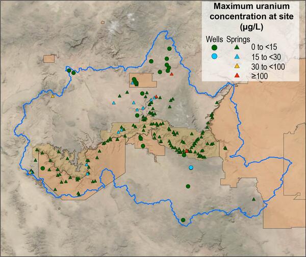
Map of Grand Canyon uranium concentrations as spring and well sites
Map of Grand Canyon uranium concentrations as spring and well sitesMap of maximum uranium concentration at 206 spring and well sites in the Grand Canyon region.
Map of Grand Canyon uranium concentrations as spring and well sites
Map of Grand Canyon uranium concentrations as spring and well sitesMap of maximum uranium concentration at 206 spring and well sites in the Grand Canyon region.
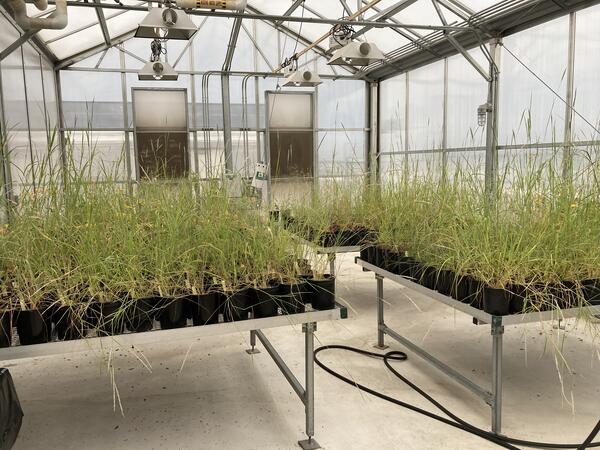
Greenhouse study comparing plant provenance for restoration
Greenhouse study comparing plant provenance for restorationRestoreNet is partnering with the Gornish lab at the University of Arizona to better understand how a plant’s source location (provenance) influences its performance in a restoration setting. This greenhouse experiment will be conducted by PhD student, Sierra Lauman.

Pre-construction monitoring of vegetation for the Gemini Solar Array
Pre-construction monitoring of vegetation for the Gemini Solar ArrayThe United States is developing renewable energy resources, especially solar, at a rapid rate.
Pre-construction monitoring of vegetation for the Gemini Solar Array
Pre-construction monitoring of vegetation for the Gemini Solar ArrayThe United States is developing renewable energy resources, especially solar, at a rapid rate.

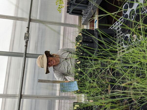
Greenhouse study comparing plant performance during drought.
Greenhouse study comparing plant performance during drought.Greenhouse study comparing plant performance during drought will help land managers choose plant species for restoring degraded lands. To find out more, follow the Restoration Assessment and Monitoring Program of the Southwest, housed at the Southwest Biolobigical Science Center. www.ugs.gov/sbsc/ramps
Drought experiments shed light on plant responses to climate change.
Drought experiments shed light on plant responses to climate change.Greenhouse study comparing plant performance during drought will help land managers choose plant species for restoring degraded lands. To find out more, follow the Restoration Assessment and Monitoring Program of the Southwest, housed at the Southwest Biolobigical Science Center. www.ugs.gov/sbsc/ramps

Powerlines & Pollinators
Connecting powerline rights-of-way vegetation management to improve pollinator habitat. A USGS RAMPS technician samples pollinating insects along the Salt River Project powerline that crosses through Apache-Sitgreaves and Tonto National Forests.
Connecting powerline rights-of-way vegetation management to improve pollinator habitat. A USGS RAMPS technician samples pollinating insects along the Salt River Project powerline that crosses through Apache-Sitgreaves and Tonto National Forests.
Pre-construction monitoring of vegetation for the Gemini Solar Array
Pre-construction monitoring of vegetation for the Gemini Solar ArrayThe United States is developing renewable energy resources, especially solar, at a rapid rate.
Pre-construction monitoring of vegetation for the Gemini Solar Array
Pre-construction monitoring of vegetation for the Gemini Solar ArrayThe United States is developing renewable energy resources, especially solar, at a rapid rate.
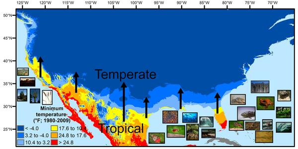
U.S. regions in the tropical-to-temperate transition
U.S. regions in the tropical-to-temperate transitionA map showing North America's tropical-to-temperate transition zone. Red, orange, and yellow depict the more tropical zones, and blues depict the more temperate zones, based on to the coldest recorded temperature for each area between 1980 and 2009.
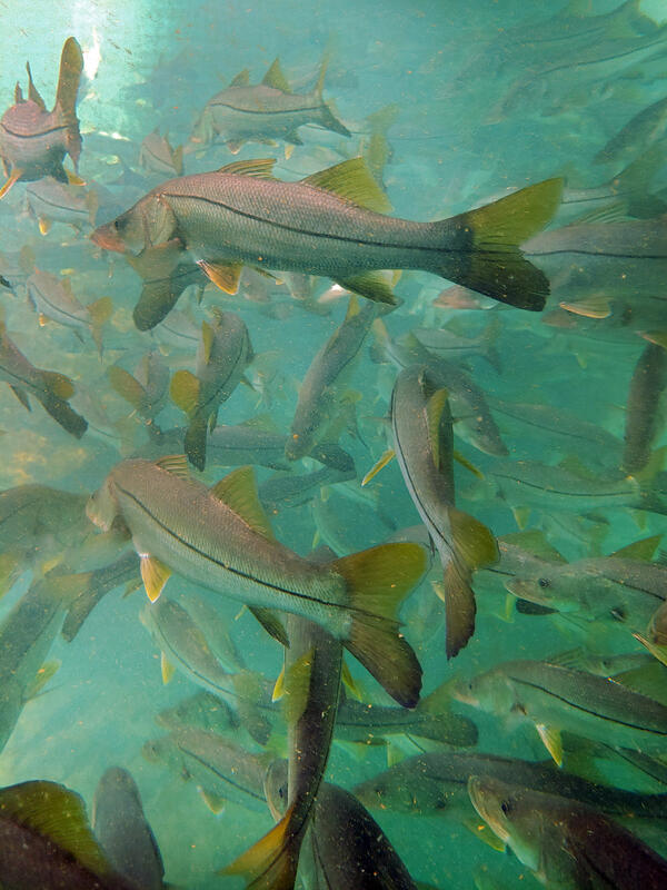
Subtropical snook gather at a warm Florida springhead in winter
Subtropical snook gather at a warm Florida springhead in winterWinter temperature extremes control the distributions of subtropical fishes. Common snook (Centropomus undecimalis), aggregate at a spring in northern Florida during winter. Snook are warm saltwater game fish, common in Florida, that have been moving further northward as extreme cold spells become less frequent and less intense.

Fires transforming Sonoran Desert
Restoring areas infested with invasive species that carry catastrophic fire is a top priority for the Restoration Assessment and Monitoring Program for the Southest (RAMPS) and our partners.
Restoring areas infested with invasive species that carry catastrophic fire is a top priority for the Restoration Assessment and Monitoring Program for the Southest (RAMPS) and our partners.

San Miguel River, Colorado, Fall 2020
Looking upstream on the San Miguel River in Colorado in fall 2020 when baseflow (groundwater flowing to streams) is the primary contributor to streamflow.
Looking upstream on the San Miguel River in Colorado in fall 2020 when baseflow (groundwater flowing to streams) is the primary contributor to streamflow.

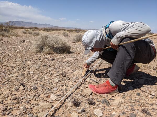
How does restoration affect soils?
How do restoration plantings alter ecosystem function? NAU PhD student Kathleen Balazs and technician Sarah Negovan measure soil water infiltration rates at a RestoreNet site near La Sal, Utah. These measurements will illustrate how restoration plantings effect certain ecosystem functions
How do restoration plantings alter ecosystem function? NAU PhD student Kathleen Balazs and technician Sarah Negovan measure soil water infiltration rates at a RestoreNet site near La Sal, Utah. These measurements will illustrate how restoration plantings effect certain ecosystem functions

Dragonfly Mercury Project specimen collection in Glacier NP
Dragonfly Mercury Project specimen collection in Glacier NPResearchers instruct volunteers on how to collect dragonfly larvae in Glacier NP as a part of the Dragonfly Mercury Project.
Dragonfly Mercury Project specimen collection in Glacier NP
Dragonfly Mercury Project specimen collection in Glacier NPResearchers instruct volunteers on how to collect dragonfly larvae in Glacier NP as a part of the Dragonfly Mercury Project.

Arid grassland
Arid grasslands in the U.S. Mexico border are fire adapted and used by diverse groups. Science from the Southwest Biological Science Center and the Restoration Assessment and Monitoring Program for the Southwest (RAMPS) is helping these groups find common ground to manage this dynamic landscape.
Arid grasslands in the U.S. Mexico border are fire adapted and used by diverse groups. Science from the Southwest Biological Science Center and the Restoration Assessment and Monitoring Program for the Southwest (RAMPS) is helping these groups find common ground to manage this dynamic landscape.

Managing Fire on the US Mexico Borderlands
RAMPS met with DOI Office of Wildland Fire, US Customs and Border Patrol, and US Fish & Wildlife Service staff at Buenos Aires National Wildlife Refuge in southern AZ last November. The group is developing tools to reduce wildfire risk, conserve wildlife habitat and natural resources, and increase safety and security of border operations.
RAMPS met with DOI Office of Wildland Fire, US Customs and Border Patrol, and US Fish & Wildlife Service staff at Buenos Aires National Wildlife Refuge in southern AZ last November. The group is developing tools to reduce wildfire risk, conserve wildlife habitat and natural resources, and increase safety and security of border operations.

RestoreNet scientists develop guidance for dryland restoration
RestoreNet scientists develop guidance for dryland restorationRestoreNet is a networked experiment testing treatments for improving restoration in drylands. Find out more at www.usgs.gov/sbsc/ramps
RestoreNet scientists develop guidance for dryland restoration
RestoreNet scientists develop guidance for dryland restorationRestoreNet is a networked experiment testing treatments for improving restoration in drylands. Find out more at www.usgs.gov/sbsc/ramps

Supporting Tribal Seed Sovereignty
USGS Restoration Assessment and Monitoring Program for the Southwest (RAMPS) is helping to build capacity in ecosystem restoration on the Navajo Nation with a series of projects in collaboration with Navajo Nation Department of Natural Hertiage, Dine Native Plant Program, and the Native-led non-profit Tolani Lake Enterprises.
USGS Restoration Assessment and Monitoring Program for the Southwest (RAMPS) is helping to build capacity in ecosystem restoration on the Navajo Nation with a series of projects in collaboration with Navajo Nation Department of Natural Hertiage, Dine Native Plant Program, and the Native-led non-profit Tolani Lake Enterprises.
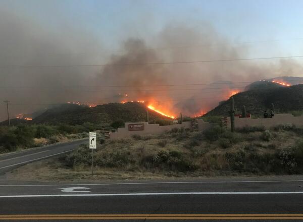
Flames from the Woodbury Fire rise above Tonto National Monument
Flames from the Woodbury Fire rise above Tonto National MonumentFlames from the Woodbury Fire rise above Tonto National Monument.
Flames from the Woodbury Fire rise above Tonto National Monument
Flames from the Woodbury Fire rise above Tonto National MonumentFlames from the Woodbury Fire rise above Tonto National Monument.

Grassland Climate Adaptation Project
Working to develop climate adaptation actions on National Park Service lands on the Colorado Plateau and 4-corners region.
Working to develop climate adaptation actions on National Park Service lands on the Colorado Plateau and 4-corners region.