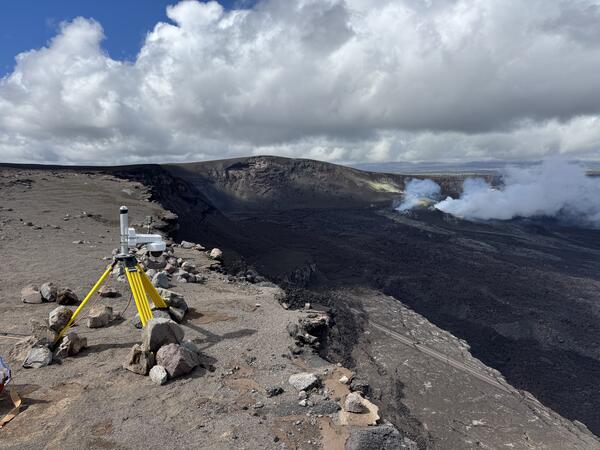
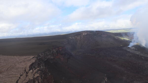
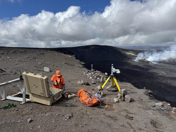
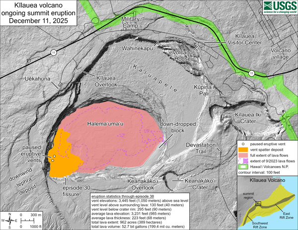
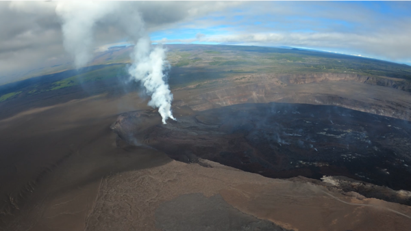
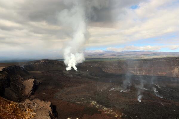
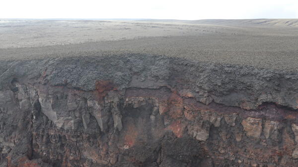
U.S. flag

An official website of the United States government

Images

Kīlauea images of eruptive activity, field work, and more.

Filter Total Items: 2923
Color photograph of erupting volcanic vent
May 5, 2025 — Telephoto view of south vent at Kīlauea volcano

This view of the south vent within Halemaʻumaʻu crater at the summit of Kīlauea was captured through the lens of a laser rangefinder device that Hawaiian Volcano Observatory scientists were using to measure eruptive features.

This view of the south vent within Halemaʻumaʻu crater at the summit of Kīlauea was captured through the lens of a laser rangefinder device that Hawaiian Volcano Observatory scientists were using to measure eruptive features.

Color photograph of erupting volcanic vent
May 1, 2025 — View of lava within north vent between eruptive episodes at Kīlauea volcano

On May 1, 2025, USGS Hawaiian Volcano Observatory scientists observed a small spatter cone that has built up within the north vent in Halemaʻumaʻu. Over the past day, spattering has been visible in the V1cam livestream within the north vent and this photo provides a closer view of the spattering source. USGS photo by K. Mulliken. 

On May 1, 2025, USGS Hawaiian Volcano Observatory scientists observed a small spatter cone that has built up within the north vent in Halemaʻumaʻu. Over the past day, spattering has been visible in the V1cam livestream within the north vent and this photo provides a closer view of the spattering source. USGS photo by K. Mulliken. 

Color photograph of volcanic vent erupting
May 1, 2025 — View of the north vent at Kīlauea volcano

On May 1, 2025, USGS Hawaiian Volcano Observatory scientists observed a small spatter cone that had built up by intermittent spattering within the north vent over the past several days in Halemaʻumaʻu.

On May 1, 2025, USGS Hawaiian Volcano Observatory scientists observed a small spatter cone that had built up by intermittent spattering within the north vent over the past several days in Halemaʻumaʻu.

Color photograph of scientist checking camera on rim of crater
May 1, 2025 — Scientist checks camera on rim of Kīlauea volcano

May 1 is lei day in Hawaii, and today scientists from the USGS Hawaiian Volcano Observatory checked on the S2cam on the rim of Kīlauea volcano. The camera had been sending images intermittently over the past 24 hours and needed new batteries.

May 1 is lei day in Hawaii, and today scientists from the USGS Hawaiian Volcano Observatory checked on the S2cam on the rim of Kīlauea volcano. The camera had been sending images intermittently over the past 24 hours and needed new batteries.

Color photograph of scientist checking monitoring equipment on the rim of a crater
May 1, 2025 — Scientist sets up camera on rim of Kīlauea volcano

A USGS Hawaiian Volcano Observatory geologist sets up a video camera to capture the intermittent minor spattering within the north vent in Halemaʻumaʻu on May 1, 2025. The north and south vents are just out of the camera frame, below the scientist in the lower left part of the photo.

A USGS Hawaiian Volcano Observatory geologist sets up a video camera to capture the intermittent minor spattering within the north vent in Halemaʻumaʻu on May 1, 2025. The north and south vents are just out of the camera frame, below the scientist in the lower left part of the photo.

Color photograph of scientist monitoring eruption
May 1, 2025—Kīlauea summit eruption monitoring

A USGS Hawaiian Volcano Observatory scientist uses a handheld laser rangefinder to determine the height of the small spatter cone within the north vent on May 1, 2025.  USGS photo by K. Mulliken. 

A USGS Hawaiian Volcano Observatory scientist uses a handheld laser rangefinder to determine the height of the small spatter cone within the north vent on May 1, 2025.  USGS photo by K. Mulliken. 

Color map showing areas covered by lava in recent eruption
April 30, 2025—Kīlauea summit eruption reference map

This reference map depicts the Kīlauea summit eruption within Halema‘uma‘u crater that began on December 23, 2024. As of this posting on April 30, 2025, the eruption has had eighteen episodes, with the most recent occurring on April 22.

This reference map depicts the Kīlauea summit eruption within Halema‘uma‘u crater that began on December 23, 2024. As of this posting on April 30, 2025, the eruption has had eighteen episodes, with the most recent occurring on April 22.

Color photograph of crater floor and degassing volcanic vents
April 29, 2025 — Overview of western Halema‘uma‘u

This overview photo of western Halema‘uma‘u crater was captured during a USGS Hawaiian Volcano Observatory monitoring helicopter overflight on Tuesday, April 29.

This overview photo of western Halema‘uma‘u crater was captured during a USGS Hawaiian Volcano Observatory monitoring helicopter overflight on Tuesday, April 29.

Color photograph of degassing volcanic vents
April 29, 2025 — Lava visible within both north and south vents between eruptive episodes at Kīlauea volcano

On April 29, the USGS Hawaiian Volcano Observatory undertook a helicopter surveillance flight over Halema‘uma‘u at the summit of Kīlauea volcano. At the time, the ongoing eruption was between eruptive episodes (episode 18 ended on April 22).

Color photograph of volcanic vent degassing and with a minor amount of incandescent lava visible within
April 29, 2025 — View of lava within north vent between eruptive episodes at Kīlauea volcano

On April 29, the USGS Hawaiian Volcano Observatory undertook a helicopter surveillance flight over Halema‘uma‘u at the summit of Kīlauea volcano. At the time, the ongoing eruption was between eruptive episodes (episode 18 ended on April 22). In this photo looking down towards the east, lava is seen within north vent.

On April 29, the USGS Hawaiian Volcano Observatory undertook a helicopter surveillance flight over Halema‘uma‘u at the summit of Kīlauea volcano. At the time, the ongoing eruption was between eruptive episodes (episode 18 ended on April 22). In this photo looking down towards the east, lava is seen within north vent.

Color photograph of a caldera with an actively degassing vent near one wall
April 29, 2025 — Kīlauea summit overview

A USGS Hawaiian Volcano Observatory monitoring helicopter overflight midday on April 29, 2025, provided views Halema‘uma‘u during a pause in eruptive activity at Kīlauea. In this view looking south, the degassing north and south vents are visible in the center right of the photo.

A USGS Hawaiian Volcano Observatory monitoring helicopter overflight midday on April 29, 2025, provided views Halema‘uma‘u during a pause in eruptive activity at Kīlauea. In this view looking south, the degassing north and south vents are visible in the center right of the photo.

Color photograph of degassing vent with a tiny amount of incandescent lava visible within it
April 29, 2025 — View of lava within north vent at Kīlauea volcano

On April 29, the USGS Hawaiian Volcano Observatory undertook a helicopter surveillance flight over Halema‘uma‘u at the summit of Kīlauea volcano. At the time, the ongoing eruption was between eruptive episodes (episode 18 ended on April 22). In this photo looking down towards the east, lava is seen within north vent.

On April 29, the USGS Hawaiian Volcano Observatory undertook a helicopter surveillance flight over Halema‘uma‘u at the summit of Kīlauea volcano. At the time, the ongoing eruption was between eruptive episodes (episode 18 ended on April 22). In this photo looking down towards the east, lava is seen within north vent.

Color photograph of deposit of ejecta material from a volcanic eruption on the rim of a caldera
April 29, 2025 — Aerial view of tephra blanket from ongoing eruption at Kīlauea

View looking southwest of the southwest corner of Halema‘uma‘u and the tephra blanket from the ongoing eruption at Kīlauea. The tephra is brown and covers center and right side of the photo.

Color photograph of volcanic crater and cone
April 29, 2025 — View of Kīlauea Iki and Pu‘upua‘i

This photograph, taken during a USGS Hawaiian Volcano Observatory monitoring helicopter overflight midday on April 29, 2025, shows an overview of Kīlauea Iki (center) and Pu‘upua‘i (bottom center to right). Kīlauea Iki erupted in 1959 over a 5-week period with 17 fountaining episodes, similar to the ongoing eruption in Halema‘uma‘u.

This photograph, taken during a USGS Hawaiian Volcano Observatory monitoring helicopter overflight midday on April 29, 2025, shows an overview of Kīlauea Iki (center) and Pu‘upua‘i (bottom center to right). Kīlauea Iki erupted in 1959 over a 5-week period with 17 fountaining episodes, similar to the ongoing eruption in Halema‘uma‘u.

Color photograph of volcanic crater
April 25, 2025 — View of Kaluapele from the southeast

During the course of routine monitoring equipment maintenance, on Friday, April 25 a Hawaiian Volcano Observatory geologist visited a site on the southeastern rim of Kaluapele (Kīlauea summit caldera) known as Akanikōlea—a culturally-significant place that is featured in Hawaiian oral traditions.

During the course of routine monitoring equipment maintenance, on Friday, April 25 a Hawaiian Volcano Observatory geologist visited a site on the southeastern rim of Kaluapele (Kīlauea summit caldera) known as Akanikōlea—a culturally-significant place that is featured in Hawaiian oral traditions.

Color photograph of degassing volcanic vents
April 25, 2025 — Kīlauea summit eruption vents degassing

This photo shows south (center) and north (right) vents degassing, three days after the end of episode 18 of Kīlauea's ongoing summit eruption. Mauna Loa's flank is visible in the upper portion of the photo. The tephra blanket (brown) from recent episodes is visible on the wall behind the vents and also draping over the ground at the top of the cliff.

This photo shows south (center) and north (right) vents degassing, three days after the end of episode 18 of Kīlauea's ongoing summit eruption. Mauna Loa's flank is visible in the upper portion of the photo. The tephra blanket (brown) from recent episodes is visible on the wall behind the vents and also draping over the ground at the top of the cliff.

Color photograph of gassy vent
April 23, 2025 — Steamy view of vents a day after episode 18 at Kīlauea's summit

View of north and south vents from the northwest, approximately 21 hours after the end of episode 18 of the eruption at Kīlauea's summit. Volcanic gases, mostly water vapor, obscure most of the view as the wind blows the gas northwards. USGS photo by N. Deligne. 

View of north and south vents from the northwest, approximately 21 hours after the end of episode 18 of the eruption at Kīlauea's summit. Volcanic gases, mostly water vapor, obscure most of the view as the wind blows the gas northwards. USGS photo by N. Deligne. 

Color photograph of material on gated road
April 23, 2025 — Tephra fall covering road near Uēkahuna at Kīlauea's summit

Episode 18 on April 22, 2025, of Kīlauea's ongoing eruption occurred during wind conditions that resulted in tephra being deposited in the Uēkahuna area, north of the vents. Hawai‘i Volcanoes National Park temporarily closed the Uēkahuna area at the time and cleaned affected roads and parking lots after episode 18 ended (foreground).

Episode 18 on April 22, 2025, of Kīlauea's ongoing eruption occurred during wind conditions that resulted in tephra being deposited in the Uēkahuna area, north of the vents. Hawai‘i Volcanoes National Park temporarily closed the Uēkahuna area at the time and cleaned affected roads and parking lots after episode 18 ended (foreground).

Color photograph of erupting lava fountain
April 22, 2025 — Episode 18 lava fountaining at Kīlauea summit

Dawn timelapse image showing the shadow of the episode 18 lava fountain in Halemaʻumaʻu on the west caldera wall at the summit of Kīlauea. USGS photo by M. Patrick.   

Dawn timelapse image showing the shadow of the episode 18 lava fountain in Halemaʻumaʻu on the west caldera wall at the summit of Kīlauea. USGS photo by M. Patrick.   

Color photo of lava fountain and stream leaving volcanic vent
April 22, 2025 — Kīlauea summit eruption episode 18

This photo shows a close up of the south vent at the summit of Kīlauea during episode 18.  USGS photo by M. Patrick. 

Color photograph of eruptive vent
April 22, 2025 — Kīlauea summit eruption episode 18

This photo shows a close up of the north vent at the summit of Kīlauea during episode 18 of the ongoing eruption.  Low fountaining supplied lava to a lava pond that was continuously overflowing the rim of the cone, creating swiftly moving cascades of lava down the flank of the cone.  USGS photo by M. Patrick. 

This photo shows a close up of the north vent at the summit of Kīlauea during episode 18 of the ongoing eruption.  Low fountaining supplied lava to a lava pond that was continuously overflowing the rim of the cone, creating swiftly moving cascades of lava down the flank of the cone.  USGS photo by M. Patrick. 

Was this page helpful?