
Map of Waiʻōhinu area, Island of Hawaiʻi, showing the location of the 3,740 year old age.
Images
Mauna Loa images of eruptive activity, field work, and more.
Filter Total Items: 353

Map of Waiʻōhinu area, Island of Hawaiʻi
Map of Waiʻōhinu area, Island of Hawaiʻi, showing the location of the 3,740 year old age.

Map of the USGS Hawaiian Volcano Observatory’s current camera network
Map of the USGS Hawaiian Volcano Observatory’s current camera networkMap of the USGS Hawaiian Volcano Observatory’s current camera network coverage. Lava-flow hazard zone 1 is outlined in yellow. Color-shaded areas are visible to at least one camera in the current network. We would like to expand the network so that it covers the grey-shaded areas in zone 1 as well. If your property has a good view

Aerial view of a bomb detonating on Mauna Loa lava flows
Aerial view of a bomb detonating on Mauna Loa lava flowsAerial view of a bomb detonating on Mauna Loa near the source of the 1935 Humu‘ula lava flow on the morning of December 27, 1935. This was one of 20 demolition bombs dropped on the lava flow that morning by the Army Bombing Squadron from Luke Field, O‘ahu.

U.S. Army Air Corps biplane prepares to drop bombs on 1935 lava flow
U.S. Army Air Corps biplane prepares to drop bombs on 1935 lava flowA U.S. Army Air Corps biplane is prepared for a mission to drop bombs on a lava flow advancing toward Hilo during the Mauna Loa 1935 eruption.
U.S. Army Air Corps biplane prepares to drop bombs on 1935 lava flow
U.S. Army Air Corps biplane prepares to drop bombs on 1935 lava flowA U.S. Army Air Corps biplane is prepared for a mission to drop bombs on a lava flow advancing toward Hilo during the Mauna Loa 1935 eruption.

Scientists examine an outcrop of ash in Hilo
USGS Hawaiian Volcano Observatory scientists examine an outcrop of reddish-brown Hilo ash during a recent study to investigate the origins of volcanic ash deposits on the Island of Hawai‘i. Age dates of lava flows above and below the Hilo ash deposit indicate that the ash was erupted between 3,000 and 14,000 years ago.
USGS Hawaiian Volcano Observatory scientists examine an outcrop of reddish-brown Hilo ash during a recent study to investigate the origins of volcanic ash deposits on the Island of Hawai‘i. Age dates of lava flows above and below the Hilo ash deposit indicate that the ash was erupted between 3,000 and 14,000 years ago.

Geologic map of the central-southeast flank of Mauna Loa
Geologic map of the central-southeast flank of Mauna LoaThe recently published "Geologic map of the central-southeast flank of Mauna Loa" (https://pubs.er.usgs.gov/publication/sim2932B), shown here, uses color to depict ages of geologic units, with warm colors denoting younger units and cool colors indicating older units.

Volcano Awareness Month 2020
Volcano Awareness Month programs offered in January 2020 are depicted by these images. Clockwise from top left: ground cracks opened at HVO's former location atop Kīlauea in 2018; fissure erupting on Mauna Loa in March 1984; crater lake within Halema‘uma‘u at Kīlauea's summit; and visitors hiking a Kahuku trail in Hawai‘i Volcanoes National Park (NPS).
Volcano Awareness Month programs offered in January 2020 are depicted by these images. Clockwise from top left: ground cracks opened at HVO's former location atop Kīlauea in 2018; fissure erupting on Mauna Loa in March 1984; crater lake within Halema‘uma‘u at Kīlauea's summit; and visitors hiking a Kahuku trail in Hawai‘i Volcanoes National Park (NPS).

PAINTING
The 1880-1881 eruption of Mauna Loa produced lava flows that came within 1.7 km (1.1 mi) of the Hilo Bay shoreline. This painting by Charles Furneaux, "Night View 1880–1881, Eruption from Hilo Bay," illustrates the first two flows as they would have been in November 1880. In reality, however, both flows would not have been visible from this vantage.
The 1880-1881 eruption of Mauna Loa produced lava flows that came within 1.7 km (1.1 mi) of the Hilo Bay shoreline. This painting by Charles Furneaux, "Night View 1880–1881, Eruption from Hilo Bay," illustrates the first two flows as they would have been in November 1880. In reality, however, both flows would not have been visible from this vantage.

Mauna Loa sulphur cone
Sulphur Cone (left), viewed toward southwest, from 3,480 m (11,420 ft) above sea level on Mauna Loa’s southwest rift zone. At right, an HVO geoscientist and technician rebuild volcanic gas monitoring equipment installed near an outgassing fissure.
Sulphur Cone (left), viewed toward southwest, from 3,480 m (11,420 ft) above sea level on Mauna Loa’s southwest rift zone. At right, an HVO geoscientist and technician rebuild volcanic gas monitoring equipment installed near an outgassing fissure.
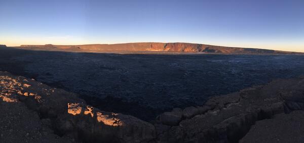
early morning view looking north across Moku‘āweoweo
early morning view looking north across Moku‘āweoweoAn early morning view looking north across Moku‘āweoweo, Mauna Loa's summit caldera, from a spot near the summit cabin on the volcano's south caldera rim. Frost covered much of the caldera floor that was still shadowed, and weak steaming issued from the usual areas. Overall, there were no significant changes observed at the summit.

HVO geologist walks along the Mauna Loa summit trail
HVO geologist walks along the Mauna Loa summit trailAn HVO geologist walks along the Mauna Loa summit trail, with Mauna Kea visible in the distant background.
HVO geologist walks along the Mauna Loa summit trail
HVO geologist walks along the Mauna Loa summit trailAn HVO geologist walks along the Mauna Loa summit trail, with Mauna Kea visible in the distant background.

Mauna Loa caldera
HVO staff visited the summit of Mauna Loa on foot to repair the webcam on April 24. The weather was perfectly clear and views of the caldera floor showed nothing unusual.
HVO staff visited the summit of Mauna Loa on foot to repair the webcam on April 24. The weather was perfectly clear and views of the caldera floor showed nothing unusual.

HVO scientists measure a GPS instrument
HVO scientists measure a GPS instrument to ensure its stability during a multi-day deployment in the Kahuku Unit of Hawai‘i Volcanoes National Park.
HVO scientists measure a GPS instrument to ensure its stability during a multi-day deployment in the Kahuku Unit of Hawai‘i Volcanoes National Park.

HVO scientists inspect a seismic station on Mauna Loa
HVO scientists inspect a seismic station on Mauna LoaHVO scientists inspect a seismic station on Mauna Loa to evaluate for a possible equipment upgrade in the near future.
HVO scientists inspect a seismic station on Mauna Loa
HVO scientists inspect a seismic station on Mauna LoaHVO scientists inspect a seismic station on Mauna Loa to evaluate for a possible equipment upgrade in the near future.

GPS survey is completed annually on Mauna Loa
A high-precision Global Positioning System (GPS) survey is completed annually on Mauna Loa. This station was occupied for a period of three days to supplement the continuously operating GPS stations on the volcano. A beautiful view of Mauna Kea (in distance) could seen from this site during the GPS survey.
A high-precision Global Positioning System (GPS) survey is completed annually on Mauna Loa. This station was occupied for a period of three days to supplement the continuously operating GPS stations on the volcano. A beautiful view of Mauna Kea (in distance) could seen from this site during the GPS survey.

Clear day view of Mauna Loa during tradewind conditions from the su...
Clear day view of Mauna Loa during tradewind conditions from the su...Clear day view of Mauna Loa during tradewind conditions from the summit of Kīlauea Volcano.
Clear day view of Mauna Loa during tradewind conditions from the su...
Clear day view of Mauna Loa during tradewind conditions from the su...Clear day view of Mauna Loa during tradewind conditions from the summit of Kīlauea Volcano.

Mauna Loa summit 1940 cinder-and-spatter cone
An aerial view of the prominent 1940 cinder-and-spatter cone on the floor of Mauna Loa's summit caldera. The cone, about 100 m (330 ft) high, was built during a 134-day-long eruption that began on April 7, 1940. Most of the caldera floor around the cone is covered by lava flows erupted in 1984.
An aerial view of the prominent 1940 cinder-and-spatter cone on the floor of Mauna Loa's summit caldera. The cone, about 100 m (330 ft) high, was built during a 134-day-long eruption that began on April 7, 1940. Most of the caldera floor around the cone is covered by lava flows erupted in 1984.

Views of Mauna Loa Volcano during clear weather day and on day when...
Views of Mauna Loa Volcano during clear weather day and on day when...These views of Mauna Loa are from near the Hawaiian Volcano Observatory looking toward the west. The view on left is typical during strong trade winds that blow the plume from Halema‘uma‘u Crater southwest of the summit area. The view on right is common during slack winds that allow vog conditions to develop in the summit area of Kīlauea.

Mauna Loa Back to Normal
View of cinder cones in the Northeast Rift Zone near the summit of Mauna Loa. View to the north-northeast with Mauna Kea in the background. Mauna Loa has erupted 33 times since 1843, most recently erupting in 1975 and 1984. Photo credit: Matt Patrick, USGS
View of cinder cones in the Northeast Rift Zone near the summit of Mauna Loa. View to the north-northeast with Mauna Kea in the background. Mauna Loa has erupted 33 times since 1843, most recently erupting in 1975 and 1984. Photo credit: Matt Patrick, USGS

Explosive eruptions at the summit of Mauna Loa: When did they occur?
Explosive eruptions at the summit of Mauna Loa: When did they occur?This light gray block of rock (backpack for scale) is part of the approximately 830-year-old explosion deposit on the northwest rim of Moku‘āweoweo, the summit caldera of Mauna Loa. USGS photo by F.A. Trusdell.

April 1868 Mauna Loa eruption can be seen in this aerial photo
April 1868 Mauna Loa eruption can be seen in this aerial photoMost of the lava flow (dark black) produced by the April 1868 Mauna Loa eruption can be seen in this aerial photo on the west (left) side of the prominent fault scarp, known informally as the Kahuku pali (formal names are Pali o Mamalu for the upper half and Pali‘okūlani for the lower half of the scarp).