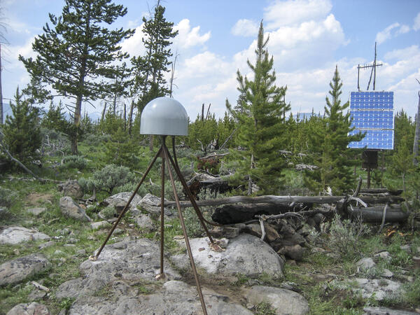
U.S. flag

An official website of the United States government

Images

Images of Yellowstone.

Filter Total Items: 681
Air photo showing newly thermal areas on Mallard Lake resurgent dome

National Agriculture Imagery Program natural-color image from September 9, 2006, showing newly mapped thermal areas (outlined in yellow) on the north side of the Mallard Lake resurgent dome.

Excelsior Geyser and Grand Prismatic Spring, Yellowstone

Aerial view of Excelsior Geyser (in the foreground) and Grand Prismatic Spring in Yellowstone’s Midway Geyser Basin. The colors around the thermal features are locations of different thermophile communities. These thermophiles fix carbon, both from the atmosphere and from the hot water. Credit Jim Peaco; June 22, 2006; Catalog #20386d; Original #IT8M4075

Aerial view of Excelsior Geyser (in the foreground) and Grand Prismatic Spring in Yellowstone’s Midway Geyser Basin. The colors around the thermal features are locations of different thermophile communities. These thermophiles fix carbon, both from the atmosphere and from the hot water. Credit Jim Peaco; June 22, 2006; Catalog #20386d; Original #IT8M4075

Old Faithful in eruption

Old Faithful Geyser in eruption. Under Yellowstone Research Permit YELL-SCI-8030, 13 mineralized wood specimens were collected from the geyser mound. The dates of the mineralized wood samples imply that such eruptions did not take place for over a century between the mid-13th to mid-14th centuries.

Old Faithful Geyser in eruption. Under Yellowstone Research Permit YELL-SCI-8030, 13 mineralized wood specimens were collected from the geyser mound. The dates of the mineralized wood samples imply that such eruptions did not take place for over a century between the mid-13th to mid-14th centuries.

Rangers attempting to clean trash out of Morning Glory Pool in 1975.

Rangers attempting to clean trash out of Morning Glory Pool in September 1975. National Park Service photograph Dan Ing.

Two photos comparing "cinders" (small spherules) with black cinders on one side and yellow on the other.
Comparison of sulfur "cinders" from two different hot springs in Yellowstone National Park

A comparison of black cinders from Cinder Pool, in Norris Geyser Basin (left), with yellow cinders from an unnamed pool in the West Nymph Creek thermal area (right).  The Cinder Pool cinders are black due to finely dispersed pyrite, whereas the yellow color of cinders from the West Nymph Creek pool is due to the lack of pyrite.

A comparison of black cinders from Cinder Pool, in Norris Geyser Basin (left), with yellow cinders from an unnamed pool in the West Nymph Creek thermal area (right).  The Cinder Pool cinders are black due to finely dispersed pyrite, whereas the yellow color of cinders from the West Nymph Creek pool is due to the lack of pyrite.

Grand Prismatic Spring, Midway Geyser Basin, Yellowstone National Park

Grand Prismatic Spring, Midway Geyser Basin, Yellowstone National Park.  Grand Prismatic is the largest hot spring in Yellowstone and the third largest in the world. Photograph by Robert Fournier.

Map of the known ash-fall boundaries for several U.S. eruptions

Eruptions of the Yellowstone volcanic system have included the two largest volcanic eruptions in North America in the past few million years; the third largest was at Long Valley in California and produced the Bishop ash bed. The biggest of the Yellowstone eruptions occurred 2.1 million years ago, depositing the Huckleberry Ridge ash bed.

Eruptions of the Yellowstone volcanic system have included the two largest volcanic eruptions in North America in the past few million years; the third largest was at Long Valley in California and produced the Bishop ash bed. The biggest of the Yellowstone eruptions occurred 2.1 million years ago, depositing the Huckleberry Ridge ash bed.

Heise cliffs, the type location for the 4.45–7.0 million year old Heise Volcanic Field

Heise cliffs, the type location for the 4.45–7.0 million year old Heise Group from the Heise volcanic field, which preceded the Yellowstone Plateau volcanic field.  Most of the cliffs exposed here are rhyolitic, densely welded, rhyolitic pyroclastic density flow deposits.  USGS Photo by L. A. Morgan (May 2005).

Heise cliffs, the type location for the 4.45–7.0 million year old Heise Group from the Heise volcanic field, which preceded the Yellowstone Plateau volcanic field.  Most of the cliffs exposed here are rhyolitic, densely welded, rhyolitic pyroclastic density flow deposits.  USGS Photo by L. A. Morgan (May 2005).

Exposure of rhyolite volcanic rocks in the central Snake River Plain

Exposure of rhyolite volcanic rocks in the central Snake River Plain showing a thick sequence of 10-12 million-year-old, densely welded, pyroclastic density flow units (darker units from middle of photo to top of hill) overlying a thick sequence of white, friable, ash fall deposits.  USGS Photo by L. A. Morgan (May 2004).

Exposure of rhyolite volcanic rocks in the central Snake River Plain showing a thick sequence of 10-12 million-year-old, densely welded, pyroclastic density flow units (darker units from middle of photo to top of hill) overlying a thick sequence of white, friable, ash fall deposits.  USGS Photo by L. A. Morgan (May 2004).

Densely welded rhyolites from the central Snake River Plain
Sheepeater Cliff, in Yellowstone National Park

Slow cooling of a basaltic lava flow that was erupted about 500,000 years ago resulted in the formation of hexagonal columns at Sheepeater Cliff, in Yellowstone National Park.

Slow cooling of a basaltic lava flow that was erupted about 500,000 years ago resulted in the formation of hexagonal columns at Sheepeater Cliff, in Yellowstone National Park.

Black and white simplified geological map
Simplified geologic map of Sepulcher Mountain area, northern Yellowstone National Park

Simplified geologic map detailing locations of volcanics at Sepulcher Mountain and igneous intrusion at Electric Peak and surrounding area. This map is Fig. 2.

Norris-2003. Location map of seismometers and GPS receivers deploye...
Columnar-jointed lava flow in the wall of the Yellowstone River canyon

A 1.5-million-year-old basaltic lava flow in the canyon wall of the Yellowstone River as viewed from Calcite Springs Overlook near Tower Junction in Yellowstone National Park.  Slow cooling of this lava flow resulted in the formation of vertical columns.  Glacial gravels are present above and below the lava flow.

A 1.5-million-year-old basaltic lava flow in the canyon wall of the Yellowstone River as viewed from Calcite Springs Overlook near Tower Junction in Yellowstone National Park.  Slow cooling of this lava flow resulted in the formation of vertical columns.  Glacial gravels are present above and below the lava flow.

Angel Terrace, Mammoth Hot Springs, Yellowstone National Park.
Angel Terrace, Mammoth Hot Springs, Yellowstone National Park

Angel Terrace, Mammoth Hot Springs, Yellowstone National Park. Travertine deposits are abundant in the area. Photo by JoAnn Holloway, 2003.

Norris-2003. Panoramic photo of the area impacted during the explos...
Panoramic photo of area impacted during explosions at Norris in 2004

View to the southeast through the area affected by the increased thermal output at Norris' Back Basin in the summer of 2003. The foreground shows steaming areas where boiling water and steam have approached the surface, resulting in increased ground temperatures.

View to the southeast through the area affected by the increased thermal output at Norris' Back Basin in the summer of 2003. The foreground shows steaming areas where boiling water and steam have approached the surface, resulting in increased ground temperatures.

Bathymetric map of Yellowstone Lake

Bathymetric map of Yellowstone Lake showing hydrothermal features in the north part of the lake, including Elliott's Crater, Mary Bay, and Deep Hole.  Colors correspond to lake depth, with cooler colors indicating greater depths.

Criteria for estimation of the Volcanic Explosivity Index (VEI)

Criteria for estimation of the Volcanic Explosivity Index (VEI).  Modified from: Newhall, C.G., and Self, S., 1982, The volcanic explosivity index (VEI): An estimate of explosive magnitude for historical volcanism. Journal of Geophysical Research, v. 87, no. C2, p.

Criteria for estimation of the Volcanic Explosivity Index (VEI).  Modified from: Newhall, C.G., and Self, S., 1982, The volcanic explosivity index (VEI): An estimate of explosive magnitude for historical volcanism. Journal of Geophysical Research, v. 87, no. C2, p.

Was this page helpful?