
Data Quality Assessment
The USGS ECCOE Team provides independent technical characterization and quality assessment of the remotely sensed data generated by a broad variety of remote sensing systems. These assessments include geometric, radiometric, and spatial characterizations, as well as identifying artifacts that may affect the use of data and resulting products.


Joint Agency Commercial Imagery Evaluation (JACIE)
ECCOE also facilitates assessments of the operability and usefulness of these data in scientific and other applications. Details from these assessments is presented at the Joint Agency Commercial Imagery Evaluation (JACIE) Annual Workshop and also compiled in reports such as annual JACIE Remote Sensing Satellite Compendiums.
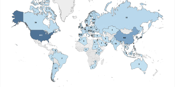
Land Remote Sensing Satellites
The Land Remote Sensing Satellites Online Compendium contains details about past, present and future Earth observing satellites and the sensors they carry.
The Land Remote Sensing Satellites webpage displays the number of commercial and/or government/civil land remote sensing satellites launched by country, and also by year.
System Characterization of Earth Observation Sensors Open-File Report
The System Characterization of Earth Observation Sensors Open-File Report 2021-1030 provides information from assessments of Earth observation sensors completed by the USGS ECCOE Team. Each chapter within this report is provided as independent measures of basic system performance by completing the geometric, radiometric, and spatial characterization. The results of these assessments are a snapshot in time. Chapters currently available are listed below; new chapters are added as assessments of additional sensors are published.
- Chapter A: German Aerospace Center (DLR) Earth Sensing Imaging Spectrometer (DESIS)
- Chapter B : Gaofen-1
- Chapter C: Planet's Dove Classic
- Chapter D: Planet's Dove R
- Chapter E: Planet SkySat
- Chapter F: Planet's SuperDove
- Chapter G: Resourcesat-2 Advanced Wide Field Sensor
- Chapter H: Resourcesat-2 Linear Imaging Self Scanning-3 (LISS–3) Sensor
- Chapter I: WorldView-3 Imager
- Chapter J: China-Brazil Earth Resources Satellite-4A (CBERS–4A)
- Chapter K: PRecursore IperSpettrale della Missione Applicativa (PRISMA)
- Chapter L: Satellogic NewSat Multispectral Sensor
- Chapter M: Gaofen-6
- Chapter N: Amazônia-1 Multispectral Sensor
- Chapter O: BlackSky Global Multispectral Sensor
- Chapter P: Pléiades Neo Imager
- Chapter Q: Vision-1
- Chapter R: Earth Surface Mineral Dust Source Investigation (EMIT) Sensor
- Chapter S: System Characterization Report on the Environmental Mapping and Analysis Program (EnMAP)
- Chapter T: System Characterization Report on Resourcesat-2A Linear Imaging Self Scanning-3 Sensor
- Chapter U: System Characterization Report on Resourcesat-2A Linear Imaging Self Scanning-4 Sensor
- Chapter V: System Characterization Report on Resourcesat-2A Advanced Wide Field Sensor
- Chapter W: System Characterization Report on Tanager