
This image shows the spectral bandpasses for the sensors on all Landsat satellites.
Multimedia
Images
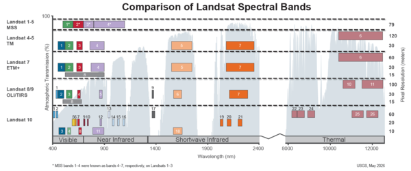
Spectral Bandpasses for all Landsat Sensors
This image shows the spectral bandpasses for the sensors on all Landsat satellites.
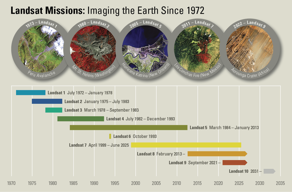
Landsat Missions Timeline
In a September 21, 1966 press release, Secretary of the Interior Stewart Udall announced that the DOI was launching "Project EROS (Earth Resources Observation Satellites)." Udall's vision was to observe the Earth for the benefit of all.
In a September 21, 1966 press release, Secretary of the Interior Stewart Udall announced that the DOI was launching "Project EROS (Earth Resources Observation Satellites)." Udall's vision was to observe the Earth for the benefit of all.
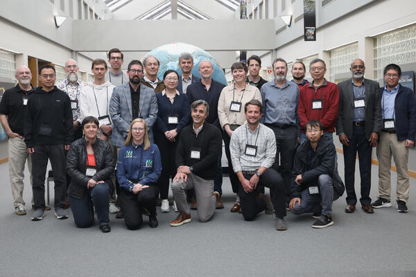
2026-2030 Landsat Science Team
The 2026-2030 Landsat Science Team met for their first in-person meeting May 5-7, 2026 at the USGS EROS Center.
The 2026-2030 Landsat Science Team met for their first in-person meeting May 5-7, 2026 at the USGS EROS Center.
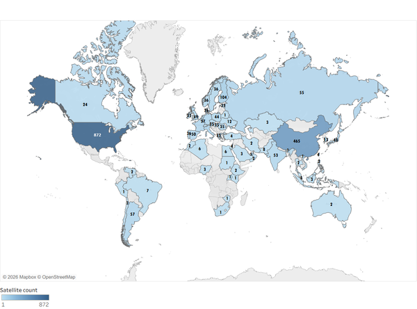
Countries with Earth Observing Satellites
The numbers on this map indicate the number of commercial and government/civil Earth observing satellites launched by the highlighted countries. This image is updated quarterly.
The numbers on this map indicate the number of commercial and government/civil Earth observing satellites launched by the highlighted countries. This image is updated quarterly.
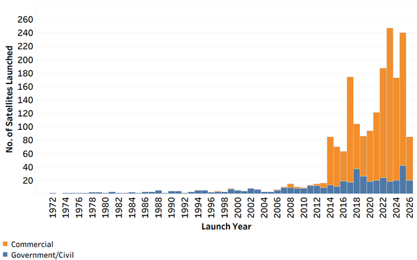
Number of Commercial, Government-Civil Earth Observing Satellites Launched
Number of Commercial, Government-Civil Earth Observing Satellites LaunchedThis chart shows the number of commercial and government/civil Earth observing satellites launched each year since 1972. This information is updated quarterly.

JACIE 2027 Save the Date
JACIE 2027 Workshop will be held April 5-9, 2027 at the USGS Headquarters in Reston, Virginia.
JACIE 2027 Workshop will be held April 5-9, 2027 at the USGS Headquarters in Reston, Virginia.
Videos

JACIE: Joint Agency Commercial Imagery Evaluation
The Joint Agency Commercial Imagery Evaluation, better known as JACIE, was created to bring together the strengths of multiple Federal agencies.
Its mission is simple, yet essential, to evaluate remote sensing data, and share those insights with the entire remote sensing community.
The Joint Agency Commercial Imagery Evaluation, better known as JACIE, was created to bring together the strengths of multiple Federal agencies.
Its mission is simple, yet essential, to evaluate remote sensing data, and share those insights with the entire remote sensing community.

B-Roll: 2025 UAS radiometric calibration and validation research in Golden, Colorado
B-Roll: 2025 UAS radiometric calibration and validation research in Golden, ColoradoCalibration and validation (cal/val) are essential steps to ensure that remotely sensed data are reliable for scientific use. Radiometric cal/val involves converting digital image pixel values to meaningful units and assessing their accuracy.

Watering the Sahara
In a remote part of the Sahara Desert in Egypt, center pivot irrigation fields fill the landscape. Thanks to the Landsat archive, we can see how dramatically this area has changed over the last 35 years. But until the growth in irrigation, this part of the world hadn't changed much from a satellite's perspective.
In a remote part of the Sahara Desert in Egypt, center pivot irrigation fields fill the landscape. Thanks to the Landsat archive, we can see how dramatically this area has changed over the last 35 years. But until the growth in irrigation, this part of the world hadn't changed much from a satellite's perspective.

Landsat's Calibration and Validation
Engineers and scientists from both Landsat and Sentinel missions are working together to calibrate observation data and validate its quality to improve the science using these resources.
Engineers and scientists from both Landsat and Sentinel missions are working together to calibrate observation data and validate its quality to improve the science using these resources.

Every Pixel - Landsat's Sensors
On board Landsat 8 are two sensors that capture data about earth's surface. Here is an explanation of the instruments that capture every pixel.
On board Landsat 8 are two sensors that capture data about earth's surface. Here is an explanation of the instruments that capture every pixel.

Every Pixel - Processing Data
Once the ground stations receive data from Landsat, there's still a lot of processing to make every pixel usable. Here's an overview of some of that work.
Once the ground stations receive data from Landsat, there's still a lot of processing to make every pixel usable. Here's an overview of some of that work.
Audio

Eyes on Earth Episode 74 – A Satellite Cross Calibration Mission
Eyes on Earth Episode 74 – A Satellite Cross Calibration MissionWhen the first Landsat satellite launched 50 years ago, it was the only game in town in terms of civilian land remote sensing. In the years that followed, a host of satellites have launched to serve similar purposes. But that data doesn't always play well together.

Eyes on Earth Episode 32 - Lunar Calibration
Calibration teams at the USGS EROS Center use a variety of methods to make sure the data collected by Landsat satellites are an accurate representation of the Earth’s surface.
Calibration teams at the USGS EROS Center use a variety of methods to make sure the data collected by Landsat satellites are an accurate representation of the Earth’s surface.

Eyes on Earth Episode 4 - Cataloging Earth Observation Satellites
Eyes on Earth Episode 4 - Cataloging Earth Observation SatellitesEarth observation used to be the province of a handful of countries with satellite technology. Today, hundreds of satellites built all over the world are launched every year. This episode of Eyes on Earth talks about the explosive growth in the civilian and commercial remote sensing and EROS’ role in it.