
Exit Creek below the mountains
Images
Browse images from a wide range of science topics covered by USGS. All items in this gallery are considered public domain unless otherwise noted.
Filter Total Items: 1612

Exit Creek and mountain view
Exit Creek below the mountains

Setting nets on Whitefish Lake on Lake Clark Nat'l Park and Preserve
Setting nets on Whitefish Lake on Lake Clark Nat'l Park and PreserveRandy Brown and Dan Young are setting nets to catch whitefish on Whitefish Lake in the Lake Clark National Park and Preserve.
Setting nets on Whitefish Lake on Lake Clark Nat'l Park and Preserve
Setting nets on Whitefish Lake on Lake Clark Nat'l Park and PreserveRandy Brown and Dan Young are setting nets to catch whitefish on Whitefish Lake in the Lake Clark National Park and Preserve.


A small flock of Sabine's Gulls
A small flock of Sabine's Gulls flying over the top of the water
A small flock of Sabine's Gulls flying over the top of the water

Tufted Puffins perching near their colony burrows on Bogoslof Island
Tufted Puffins perching near their colony burrows on Bogoslof IslandTufted Puffins perching near their burrows in a colony on Bogoslof Island (volcano) in the Aleutian Islands.
Tufted Puffins perching near their colony burrows on Bogoslof Island
Tufted Puffins perching near their colony burrows on Bogoslof IslandTufted Puffins perching near their burrows in a colony on Bogoslof Island (volcano) in the Aleutian Islands.
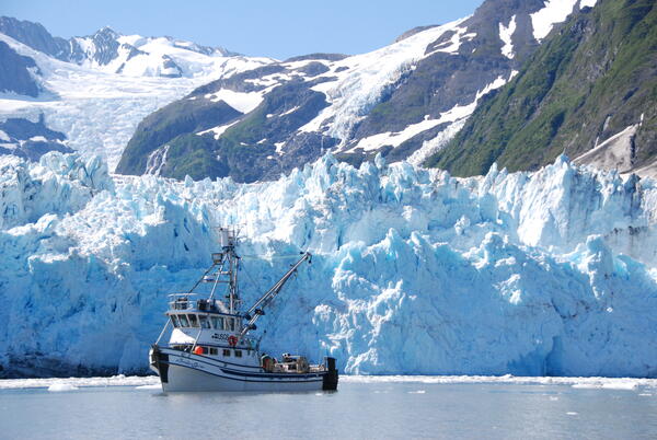
R/V Alaskan Gyre research vessel in Prince William Sound, Alaska
R/V Alaskan Gyre research vessel in Prince William Sound, AlaskaA view of the R/V Alaskan Gyre with a glacier in the background in Harriman Fjord in Prince William Sound, Alaska.
R/V Alaskan Gyre research vessel in Prince William Sound, Alaska
R/V Alaskan Gyre research vessel in Prince William Sound, AlaskaA view of the R/V Alaskan Gyre with a glacier in the background in Harriman Fjord in Prince William Sound, Alaska.

USGS team looking at a tsunami-rafted log above Stardust Bay, Alaska
USGS team looking at a tsunami-rafted log above Stardust Bay, AlaskaUSGS Alaska Earthquake Hazards research team investigates a tsunami-rafted drift log high above sea level at Stardust Bay, Sedanka Island, Alaska.
USGS team looking at a tsunami-rafted log above Stardust Bay, Alaska
USGS team looking at a tsunami-rafted log above Stardust Bay, AlaskaUSGS Alaska Earthquake Hazards research team investigates a tsunami-rafted drift log high above sea level at Stardust Bay, Sedanka Island, Alaska.

A degrading trough network on the Arctic Coastal Plain
A degrading trough network on the Arctic Coastal PlainA degrading trough network on the Arctic Coastal Plain.
A degrading trough network on the Arctic Coastal Plain
A degrading trough network on the Arctic Coastal PlainA degrading trough network on the Arctic Coastal Plain.

Young Northern Shrike captured at a Seward Peninsula banding station
Young Northern Shrike captured at a Seward Peninsula banding stationA young Northern Shrike captured at a banding station on the Seward Peninsula. This photo was taken as part Phase 1 of the Changing Arctic Ecosystem Boreal-Arctic Transition Zone program.

Age 1 and 0 Pacific sand lance in Prince William Sound, Alaska
Age 1 and 0 Pacific sand lance in Prince William Sound, AlaskaTwo different age classes of sand lance showing length differences and condition between fish in an age class.
Age 1 and 0 Pacific sand lance in Prince William Sound, Alaska
Age 1 and 0 Pacific sand lance in Prince William Sound, AlaskaTwo different age classes of sand lance showing length differences and condition between fish in an age class.

Thawing ice wedges create ponds on the Arctic Coastal Plain
Thawing ice wedges create ponds on the Arctic Coastal PlainThawing ice wedges create ponds on the Arctic Coastal Plain. The shape of these ponds influences how their water levels and nutrient concentrations change over the year. These variables in turn influence pond ecosystems and use by waterbirds.

Adult Female Walruses on Ice Floe with Young
Adult female walruses on ice floe with young.

Table Top Mountain and the West Twin Creek Catchment
Table Top Mountain and the West Twin Creek CatchmentTable Top Mountain and the West Twin Creek catchment.
Table Top Mountain and the West Twin Creek Catchment
Table Top Mountain and the West Twin Creek CatchmentTable Top Mountain and the West Twin Creek catchment.

USGS scientist banding a Bluethroat on the Seward Peninsula, Alaska
USGS scientist banding a Bluethroat on the Seward Peninsula, AlaskaUSGS scientist Rachel Richardson banding a Bluethroat on the Seward Peninsula in Alaska.
USGS scientist banding a Bluethroat on the Seward Peninsula, Alaska
USGS scientist banding a Bluethroat on the Seward Peninsula, AlaskaUSGS scientist Rachel Richardson banding a Bluethroat on the Seward Peninsula in Alaska.

Using ground penetrating radar
Colin and Colby use ground penetrating radar to measure the depth to ground ice in the watershed
Colin and Colby use ground penetrating radar to measure the depth to ground ice in the watershed

Adult Female Walrus on Ice Floe
Adult female walrus on ice floe.

Radio Tagged Adult Female Walrus on Ice Floe
Adult female walrus on ice floe photographed shortly after receiving a behavior monitoring satellite-linked radio tag from USGS researchers.
Data acquired from such radio-tags are providing insights on the distribution and behavior of Pacific walruses during a time when their summer sea ice habitat is rapidly changing.

Pacific Walruses Resting on Sea Ice
Female walruses and their young must haul out of the water to rest between foraging bouts.
Female walruses and their young must haul out of the water to rest between foraging bouts.

Adult Female Walruses on Ice Floe with Young
Adult female walruses on ice floe with young. Notice the radio tag borne on her her upper mid back.
This tag will monitor resting and foraging behavior and convey the information back to USGS scientists.
Adult female walruses on ice floe with young. Notice the radio tag borne on her her upper mid back.
This tag will monitor resting and foraging behavior and convey the information back to USGS scientists.

Catch of forage fish from a trawl in Prince William Sound, Alaska
Catch of forage fish from a trawl in Prince William Sound, AlaskaCatch of forage fish from a trawl in Prince William Sound, Alaska. Trawling was part of detecting long-term changes in forage fish populations.
Catch of forage fish from a trawl in Prince William Sound, Alaska
Catch of forage fish from a trawl in Prince William Sound, AlaskaCatch of forage fish from a trawl in Prince William Sound, Alaska. Trawling was part of detecting long-term changes in forage fish populations.

A bald eagle in a tree with a small sea otter pup
A bald eagle rests in a tree with a small sea otter pup it has just snatched from the water. Once pups are a few weeks older they have grown too large for eagles to lift. Female otters with very small pups often only do short foraging dives and continuously monitor and reposition their pups to keep them from being predated.
A bald eagle rests in a tree with a small sea otter pup it has just snatched from the water. Once pups are a few weeks older they have grown too large for eagles to lift. Female otters with very small pups often only do short foraging dives and continuously monitor and reposition their pups to keep them from being predated.