
Ecosystems on the Edge: Landscape and Fire Ecology of Forests, Deserts, and Tundra
Climate changes and interacting disturbances such as wildfires, insect and disease outbreaks, and erosion and flooding can perturb and reorganize ecosystems.
Return to Landscape Science or Hazards
Climate changes and interacting disturbances such as wildfires, insect and disease outbreaks, and erosion and flooding can perturb and reorganize ecosystems. Disturbances that are large and severe or that are beyond the bounds of historical range of variability can abruptly reorganize ecosystems, posing serious threats to ecosystem integrity and resilience. Sudden and persistent changes in biological and physical environments impact animal and human communities and pose great challenges for land and resource management.
We focus on integrating field studies, in-situ instrumentation and monitoring, ecosystem and fire models, geospatial and statistical modeling and analysis, and ecological theory to understand how, when, and where ecosystems on the edge will be affected by the synergistic interactions of climate and disturbances regimes – and what may be done to buffer or mitigate negative impacts.
Fire regimes and forests: Causes and consequences of changing fire patterns, behavior, and effects
The boreal and sub-boreal forests of Alaska are warming approximately twice as fast the global average, and this warming is the likely cause of increased frequency of wildfires in boreal forests. To the surprise and concern of fire and resource managers some fires are now burning across fire scars from the previous decade or decades, an uncharacteristic phenomenon in boreal forests, where intervals between fires are typically much longer.
This dynamic is significant in terms of management - past fires serve as fire breaks that are factored into active fire planning for protection of life, infrastructure, and resources - and ecology, because changes in fire frequency and severity can substantially alter vegetation species composition, critical wildlife habitat, and long-term carbon balance.
The USGS, in collaboration with the National Park Service, US Fish and Wildlife Service, Bureau of Land Management, and State of Alaska, has been mapping patterns of wildfires and monitoring fire impacts in boreal and sub-boreal forests to determine the causes and consequences of changing fire regimes and ecosystems. This project provides our partners with critical information for anticipating and responding to the ongoing challenge of fire and resource management in a changing world.

Modeling and mapping coupled natural-human systems in disturbance-prone environments
Coupled natural-human systems are those in which feedbacks exist between natural and human systems; these feedbacks can amplify the burden of environmental stressors such as anthropogenic climate change and associated impacts.
Nearly all natural systems are influenced by and provide services to human communities, but this is particularly true for Alaska, where people in rural communities are dependent on stable, subsistence economies and where the impacts of global climate change are extremely pronounced. There is an urgent need to document and predict impacts, yet relatively little is known about past patterns and recent changes in Alaska’s rural, natural-human environments.
The USGS, in collaboration with Alaska Native villages and Tribal and Traditional Councils and the US Fish and Wildlife Service, has developed a novel project combining traditional ecological knowledge with ongoing ecological monitoring to provide land managers and communities with critical information about changes in human-natural systems, and inform adaptation strategies for local communities.

Quantifying ecological resilience in a changing world
Resilience – an ecosystem’s capacity to absorb perturbations but maintain key relationships – is central to many land-management strategies. Because this term is difficult to measure and rarely quantified, it has been challenging to translate into land management policy. Wildfires are an essential component of resilience-focused land-management strategies, but because fire is a complex process it challenges any simple definition of what resilient ecosystems look like, when they are vulnerable to change, and how resilience-focused management actions can be effectively implemented.
The USGS, in collaboration with the US Forest Service, National Park Service, US Fish and Wildlife Service, and university partners, is developing a suite of modeling- and data-based tools to aid in integrating wildfires and changing fire regimes into ecological resilience assessments. These tools can be used by ecologists, planners, and managers as a means for evaluating priorities and strategies for resilience management in fire-prone landscapes.

Rapid ecosystem changes in tundra biomes – implications for landscapes and humans
The Yukon-Kuskokwim Delta (YKD) encompasses the southernmost, warmest parts of the arctic tundra biome and is renowned for its high biological productivity and large subsistence-based human population. Recent and rapidly-occurring environmental changes in this region include significant winter and spring warming, decreased sea ice extent, loss of snow cover, warming permafrost, and recurrent tundra fires, which cause significant changes in plant communities and ecosystem primary productivity.
Many plant species in the YKD serve as ecological keystones and cultural keystones – species fundamentally important for natural and human communities. For example, berry-producing plants in the YKD fuel long-distance bird migrations and provide Alaska Native families with critical subsistence resources.
The YKD has been underrepresented in past studies of arctic environmental change, but the USGS, in collaboration with the US Fish and Wildlife Service and others, has developed a long-term monitoring project to detect recent ecosystem changes in tundra biomes and provide our partners with information on when, where, and how future changes may occur.

Linking field-based and experimental methods to quantify, predict, and manage fire effects on cultural resources
Cultural resources - physical features associated with human activity – are non-renewable, protected by law, are highly significant to living peoples, and offer unique insights into the long-term tenure of humans in dynamic environments. Wildfires can alter cultural resources through immediate effects such as destruction of structures and chemical and physical changes to artifacts, or via post-fire effects such as erosion and debris flows. Damage to cultural artifacts and sites constitutes a permanent loss of knowledge and information about the past.
Fuels treatments have been shown to reduce fire severity, but effectiveness of risk mitigation operations is constrained by lack of information. This large project – a long-term collaboration among archaeologists, ecologists, wildfire practitioners and planners, land and resource managers, and fuels specialists from the USGS, US Forest Service, National Park Service, and local and state agencies, provides information critical to mitigating wildfire impacts, preserving the integrity of cultural resources in fire-prone environments, and integrating cultural resources and fire management decision processes.

Landsat’s unrivaled view helps map ecosystem disturbance and succession across the Kenai Peninsula
Forest loss and associated land cover change has been a significant issue on Alaska’s Kenai Peninsula in recent decades. Spruce bark beetle (Dendroctonus rufipennis) outbreaks, natural and human-caused wildfires, shrub expansion, lake drying, permafrost thaw and industrial activities have all contributed to extensive land cover change across the peninsula.
Detecting, mapping and tracking the cumulative effects of these disturbances is important for state and federal resource management agencies. However, a “wall-to-wall” land cover change analysis is presently difficult because different methodologies have been employed to document disturbance and classify land cover types over time. This study aims to develop a simplified and consistent series of spatially explicit, land cover types estimated from Landsat imagery across the Kenai Peninsula between 1973 and 2017. Comparing these new land cover maps allows for the detection and quantification of land cover change across the peninsula over time. The results from this work will better inform further analysis of resilient and vulnerable ecosystems across the peninsula.

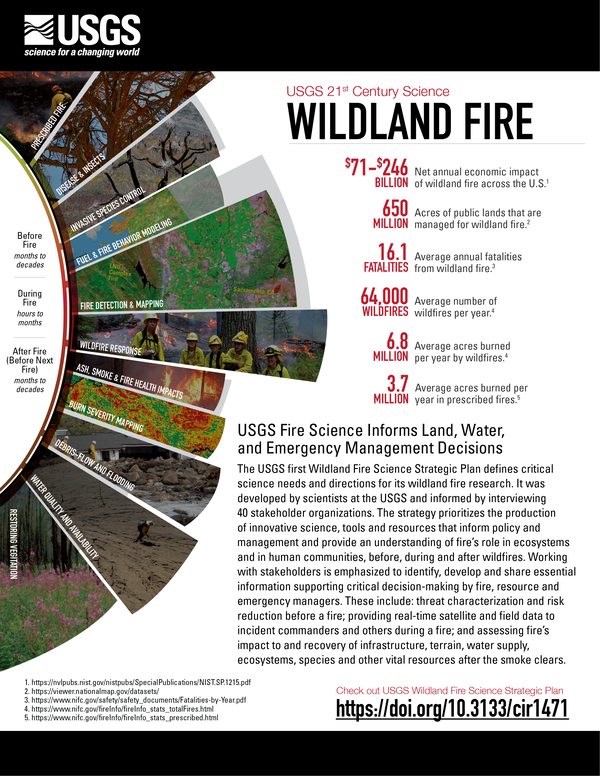
USGS Wildland Fire Science
Wildfires over the last couple decades have increased in size and severity and the fire season has lengthened, resulting in increased wildfire suppression costs and greater risks to human health and safety. Large, severe fires have had pronounced effects on water quality and quantity, air quality, fish and wildlife habitat, and many other ecosystem services, and the ability of ecosystems to recover after fires.
However, wildland fire plays an important and beneficial role in fire-adapted ecosystems and can reduce future wildfire risk and improve habitat for fire adapted species. The USGS produces wildland fire science, data, and tools that are essential to decision making before, during, and after wildfires, and are used by fire and land management agencies, states and tribes, landowners, and communities across the U.S.
Areas of emphasis for fire science work at USGS include effects of wildfire and prescribed fire on plants, wildlife and ecosystems; fire history and post-fire restoration and recovery; post-fire flooding, sedimentation, debris flow, and smoke; and remote sensing and geospatial data, tools and products to support decision making by fire and land managers.
Climate changes and interacting disturbances such as wildfires, insect and disease outbreaks, and erosion and flooding can perturb and reorganize ecosystems.
Return to Landscape Science or Hazards
Climate changes and interacting disturbances such as wildfires, insect and disease outbreaks, and erosion and flooding can perturb and reorganize ecosystems. Disturbances that are large and severe or that are beyond the bounds of historical range of variability can abruptly reorganize ecosystems, posing serious threats to ecosystem integrity and resilience. Sudden and persistent changes in biological and physical environments impact animal and human communities and pose great challenges for land and resource management.
We focus on integrating field studies, in-situ instrumentation and monitoring, ecosystem and fire models, geospatial and statistical modeling and analysis, and ecological theory to understand how, when, and where ecosystems on the edge will be affected by the synergistic interactions of climate and disturbances regimes – and what may be done to buffer or mitigate negative impacts.
Fire regimes and forests: Causes and consequences of changing fire patterns, behavior, and effects
The boreal and sub-boreal forests of Alaska are warming approximately twice as fast the global average, and this warming is the likely cause of increased frequency of wildfires in boreal forests. To the surprise and concern of fire and resource managers some fires are now burning across fire scars from the previous decade or decades, an uncharacteristic phenomenon in boreal forests, where intervals between fires are typically much longer.
This dynamic is significant in terms of management - past fires serve as fire breaks that are factored into active fire planning for protection of life, infrastructure, and resources - and ecology, because changes in fire frequency and severity can substantially alter vegetation species composition, critical wildlife habitat, and long-term carbon balance.
The USGS, in collaboration with the National Park Service, US Fish and Wildlife Service, Bureau of Land Management, and State of Alaska, has been mapping patterns of wildfires and monitoring fire impacts in boreal and sub-boreal forests to determine the causes and consequences of changing fire regimes and ecosystems. This project provides our partners with critical information for anticipating and responding to the ongoing challenge of fire and resource management in a changing world.
Modeling and mapping coupled natural-human systems in disturbance-prone environments
Coupled natural-human systems are those in which feedbacks exist between natural and human systems; these feedbacks can amplify the burden of environmental stressors such as anthropogenic climate change and associated impacts.
Nearly all natural systems are influenced by and provide services to human communities, but this is particularly true for Alaska, where people in rural communities are dependent on stable, subsistence economies and where the impacts of global climate change are extremely pronounced. There is an urgent need to document and predict impacts, yet relatively little is known about past patterns and recent changes in Alaska’s rural, natural-human environments.
The USGS, in collaboration with Alaska Native villages and Tribal and Traditional Councils and the US Fish and Wildlife Service, has developed a novel project combining traditional ecological knowledge with ongoing ecological monitoring to provide land managers and communities with critical information about changes in human-natural systems, and inform adaptation strategies for local communities.
Quantifying ecological resilience in a changing world
Resilience – an ecosystem’s capacity to absorb perturbations but maintain key relationships – is central to many land-management strategies. Because this term is difficult to measure and rarely quantified, it has been challenging to translate into land management policy. Wildfires are an essential component of resilience-focused land-management strategies, but because fire is a complex process it challenges any simple definition of what resilient ecosystems look like, when they are vulnerable to change, and how resilience-focused management actions can be effectively implemented.
The USGS, in collaboration with the US Forest Service, National Park Service, US Fish and Wildlife Service, and university partners, is developing a suite of modeling- and data-based tools to aid in integrating wildfires and changing fire regimes into ecological resilience assessments. These tools can be used by ecologists, planners, and managers as a means for evaluating priorities and strategies for resilience management in fire-prone landscapes.
Rapid ecosystem changes in tundra biomes – implications for landscapes and humans
The Yukon-Kuskokwim Delta (YKD) encompasses the southernmost, warmest parts of the arctic tundra biome and is renowned for its high biological productivity and large subsistence-based human population. Recent and rapidly-occurring environmental changes in this region include significant winter and spring warming, decreased sea ice extent, loss of snow cover, warming permafrost, and recurrent tundra fires, which cause significant changes in plant communities and ecosystem primary productivity.
Many plant species in the YKD serve as ecological keystones and cultural keystones – species fundamentally important for natural and human communities. For example, berry-producing plants in the YKD fuel long-distance bird migrations and provide Alaska Native families with critical subsistence resources.
The YKD has been underrepresented in past studies of arctic environmental change, but the USGS, in collaboration with the US Fish and Wildlife Service and others, has developed a long-term monitoring project to detect recent ecosystem changes in tundra biomes and provide our partners with information on when, where, and how future changes may occur.
Linking field-based and experimental methods to quantify, predict, and manage fire effects on cultural resources
Cultural resources - physical features associated with human activity – are non-renewable, protected by law, are highly significant to living peoples, and offer unique insights into the long-term tenure of humans in dynamic environments. Wildfires can alter cultural resources through immediate effects such as destruction of structures and chemical and physical changes to artifacts, or via post-fire effects such as erosion and debris flows. Damage to cultural artifacts and sites constitutes a permanent loss of knowledge and information about the past.
Fuels treatments have been shown to reduce fire severity, but effectiveness of risk mitigation operations is constrained by lack of information. This large project – a long-term collaboration among archaeologists, ecologists, wildfire practitioners and planners, land and resource managers, and fuels specialists from the USGS, US Forest Service, National Park Service, and local and state agencies, provides information critical to mitigating wildfire impacts, preserving the integrity of cultural resources in fire-prone environments, and integrating cultural resources and fire management decision processes.
Landsat’s unrivaled view helps map ecosystem disturbance and succession across the Kenai Peninsula
Forest loss and associated land cover change has been a significant issue on Alaska’s Kenai Peninsula in recent decades. Spruce bark beetle (Dendroctonus rufipennis) outbreaks, natural and human-caused wildfires, shrub expansion, lake drying, permafrost thaw and industrial activities have all contributed to extensive land cover change across the peninsula.
Detecting, mapping and tracking the cumulative effects of these disturbances is important for state and federal resource management agencies. However, a “wall-to-wall” land cover change analysis is presently difficult because different methodologies have been employed to document disturbance and classify land cover types over time. This study aims to develop a simplified and consistent series of spatially explicit, land cover types estimated from Landsat imagery across the Kenai Peninsula between 1973 and 2017. Comparing these new land cover maps allows for the detection and quantification of land cover change across the peninsula over time. The results from this work will better inform further analysis of resilient and vulnerable ecosystems across the peninsula.
USGS Wildland Fire Science
Wildfires over the last couple decades have increased in size and severity and the fire season has lengthened, resulting in increased wildfire suppression costs and greater risks to human health and safety. Large, severe fires have had pronounced effects on water quality and quantity, air quality, fish and wildlife habitat, and many other ecosystem services, and the ability of ecosystems to recover after fires.
However, wildland fire plays an important and beneficial role in fire-adapted ecosystems and can reduce future wildfire risk and improve habitat for fire adapted species. The USGS produces wildland fire science, data, and tools that are essential to decision making before, during, and after wildfires, and are used by fire and land management agencies, states and tribes, landowners, and communities across the U.S.
Areas of emphasis for fire science work at USGS include effects of wildfire and prescribed fire on plants, wildlife and ecosystems; fire history and post-fire restoration and recovery; post-fire flooding, sedimentation, debris flow, and smoke; and remote sensing and geospatial data, tools and products to support decision making by fire and land managers.