
Land-Use Monitoring and Forecasting
Land-Use Monitoring and Forecasting
New high-resolution, land-use and change data improves decision-making in the Chesapeake Bay watershed
Efforts are underway to protect the rich array of lands and habitat across the Bay watershed for fish, wildlife, and people. However, new high-resolution data show an alarming loss of forests and other vital lands because of development. The USGS is leading analyses of the enhanced land-change data, and forecasting scenarios of future use, to inform land-protection and local-planning decisions.
Filter Total Items: 26
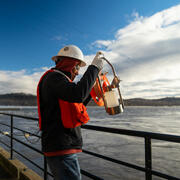
USGS Chesapeake Bay Science Accomplishments for 2025
The Chesapeake Bay watershed is home to 18 million people and some of America’s most treasured natural resources – lands, waters, and wildlife that support a strong economy and cherished outdoor traditions, such as hunting and fishing. From local organizations to federal agencies, partners throughout the watershed are working to protect these resources. These partners rely on our unbiased, gold...
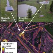
Remotely mapping stormwater facility footprints and storage volumes
Stormwater management practices are being used throughout the Chesapeake Bay watershed to reduce flood risks and pollutant loads, but consistent and comprehensive maps of these practices are often lacking. Stormwater managers often have incomplete information about the location and storage volume of stormwater facilities within their jurisdiction. Therefore, the USGS is working to develop...
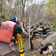
Using monitoring data to measure conditions over time in Chesapeake Bay streams
This study provides a comprehensive assessment of the health of streams throughout the Chesapeake Bay. Monitoring data were used to assess seven key indicators of stream condition, revealing consistent patterns of degradation in urban and agricultural areas. The findings offer critical insights that can inform watershed restoration efforts and improve long-term monitoring strategies.
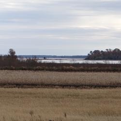
Prioritizing marsh restoration needs throughout Chesapeake Bay
A new USGS study estimates potential losses of Chesapeake Bay salt marshes that could occur in the next 80 years if no marsh restoration is undertaken. Using a suite of models, USGS researchers identified how future potential marsh changes can be used to prioritize present-day site-specific planning and restoration needs.

Key considerations to accurately predict tidal marsh longevity
A recent study provides key considerations about modeling the timeline of tidal marsh longevity. These timelines can help resource managers envision what future marsh conditions may look like, informing current and long-term adaptive management strategies.

Coastal Wetland Vulnerability to Climate Change and Sea-Level Rise: Understanding Ecological Thresholds and Ecosystem Transformations
Eighteen USGS coastal scientists from all four coasts of the conterminous United States are working together to advance the understanding of climate change and sea-level rise impacts to coastal wetlands.
By
California Water Science Center, Chesapeake Bay Activities, Eastern Ecological Science Center, Florence Bascom Geoscience Center, Great Lakes Science Center, Pacific Coastal and Marine Science Center, St. Petersburg Coastal and Marine Science Center, Western Ecological Research Center (WERC), Western Geographic Science Center, Wetland and Aquatic Research Center , Woods Hole Coastal and Marine Science Center

Discovering Connections Across America's Lands and Waters
Through collaboration and coordination, USGS research helps preserve and restore America’s most iconic landscapes. We apply insights across ecosystems to understand how these systems function and change, helping natural resource managers protect our Nation’s natural heritage for generations to come.
USGS Chesapeake Accomplishments and Highlights for 2024
As a home to 18 million people and a destination for countless visitors seeking recreational opportunities, the health of the Chesapeake Bay watershed is of critical importance. The U.S. Geological Survey (USGS) is a leading provider of data-driven insights about the condition of the watershed’s lands, waters, fish, and wildlife. These insights and our collaborative work with partners throughout...

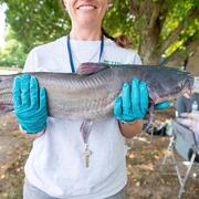
New study highlights linkages among land use, water chemistry, and the health of Smallmouth Bass in the Susquehanna River watershed
Contaminants associated with agricultural and developed land uses may negatively affect SMB health and disease resistance in the Susquehanna River watershed.

New study highlights impact of current and historic land use on stream incision in Maryland Piedmont headwaters
A new method was developed to remotely identify small, eroding streams and measure change over time.

Chesapeake Bay Land Use and Land Cover data is now published in additional formats
The Chesapeake Bay Land Use and Land Cover (LULC) database was developed by the University of Vermont’s Spatial Analysis Laboratory in cooperation with Chesapeake Conservancy (CC) and U.S. Geological Survey (USGS). The high-resolution land data were developed as part of a 6-year Cooperative Agreement between Chesapeake Conservancy and the U.S. Environmental Protection Agency (EPA), and a separate...

USGS Collaborates on Maryland Healthy Watersheds Assessment
Issue: The Maryland Healthy Watersheds Assessment (MDHWA) establishes a framework to assess watershed health and vulnerability for Maryland waters and watersheds. The assessment is intended to inform watershed management decision-making to sustain the health of State-identified healthy watersheds, which have been defined in Maryland as the watersheds associated with its designated high-quality...