
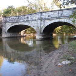
Watershed Characterization and Protection
Watershed Characterization and Protection
Filter Total Items: 15

The “sediment shadow” in Chesapeake Bay’s tidal freshwater rivers has important implications for restoration
Chesapeake Bay restoration efforts are focused on reducing nitrogen, phosphorus, and sediment loads to the estuary. A new synthesis of existing long-term records of suspended-sediment concentrations suggests that only a limited amount of watershed sediment is currently transported by rivers past the tidal freshwater zone and into saltier waters of the Chesapeake Bay.
USGS Chesapeake Bay Science Accomplishments for 2025
The Chesapeake Bay watershed is home to 18 million people and some of America’s most treasured natural resources – lands, waters, and wildlife that support a strong economy and cherished outdoor traditions, such as hunting and fishing. From local organizations to federal agencies, partners throughout the watershed are working to protect these resources. These partners rely on our unbiased, gold...
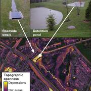
Remotely mapping stormwater facility footprints and storage volumes
Stormwater management practices are being used throughout the Chesapeake Bay watershed to reduce flood risks and pollutant loads, but consistent and comprehensive maps of these practices are often lacking. Stormwater managers often have incomplete information about the location and storage volume of stormwater facilities within their jurisdiction. Therefore, the USGS is working to develop...
Using monitoring data to measure conditions over time in Chesapeake Bay streams
This study provides a comprehensive assessment of the health of streams throughout the Chesapeake Bay. Monitoring data were used to assess seven key indicators of stream condition, revealing consistent patterns of degradation in urban and agricultural areas. The findings offer critical insights that can inform watershed restoration efforts and improve long-term monitoring strategies.
Prioritizing marsh restoration needs throughout Chesapeake Bay
A new USGS study estimates potential losses of Chesapeake Bay salt marshes that could occur in the next 80 years if no marsh restoration is undertaken. Using a suite of models, USGS researchers identified how future potential marsh changes can be used to prioritize present-day site-specific planning and restoration needs.
Applying Multiple Tools to Inform Management of Per- and Polyfluoroalkyl Substances (PFAS) in the Potomac River Watershed
The reuse of municipal wastewater provides multiple benefits, including maintaining stream flow, recharging aquifers, and providing public water supply. However, along with the benefits are concerns related to the presence of ‘forever’ chemicals, like per- and polyfluoroalkyl substances (PFAS) in wastewater discharge. Managing PFAS in waterways is challenging because there are many potential PFAS...

Informing Freshwater Management Strategies in the Chesapeake Bay Watershed by Using Observational Data and Expert Knowledge to Identify Influential Stressors
Human activities in the Chesapeake Bay watershed can negatively affect the abundance and diversity of macroinvertebrate communities in freshwater streams, which is a core measure of stream health. For example, urban development and agricultural intensification can degrade habitat and water-quality conditions in streams through sedimentation, nutrient runoff, and changes to instream habitat. A...

Coastal Wetland Vulnerability to Climate Change and Sea-Level Rise: Understanding Ecological Thresholds and Ecosystem Transformations
Eighteen USGS coastal scientists from all four coasts of the conterminous United States are working together to advance the understanding of climate change and sea-level rise impacts to coastal wetlands.
By
California Water Science Center, Chesapeake Bay Activities, Eastern Ecological Science Center, Florence Bascom Geoscience Center, Great Lakes Science Center, Pacific Coastal and Marine Science Center, St. Petersburg Coastal and Marine Science Center, Western Ecological Research Center (WERC), Western Geographic Science Center, Wetland and Aquatic Research Center , Woods Hole Coastal and Marine Science Center

USGS Chesapeake Accomplishments and Highlights for 2024
As a home to 18 million people and a destination for countless visitors seeking recreational opportunities, the health of the Chesapeake Bay watershed is of critical importance. The U.S. Geological Survey (USGS) is a leading provider of data-driven insights about the condition of the watershed’s lands, waters, fish, and wildlife. These insights and our collaborative work with partners throughout...

Using Multiple Indicators to Assess Stream Condition in the Chesapeake Bay
USGS is working with federal, state and local partners to develop multiple assessments of stream and river conditions in non-tidal areas of the Chesapeake Bay watershed. These assessments will help managers preserve stream health and improve biological conditions in impaired streams as the human population and climate continue to change in this region.

USGS Collaborates on Maryland Healthy Watersheds Assessment
Issue: The Maryland Healthy Watersheds Assessment (MDHWA) establishes a framework to assess watershed health and vulnerability for Maryland waters and watersheds. The assessment is intended to inform watershed management decision-making to sustain the health of State-identified healthy watersheds, which have been defined in Maryland as the watersheds associated with its designated high-quality...

New high-resolution, land-use and change data improves decision-making in the Chesapeake Bay watershed
Issue Informing restoration across the nearly 64,000 square miles of the Chesapeake Bay watershed is an enormous challenge that requires detailed and accessible landscape data. Among the most pressing challenges being addressed by the Chesapeake Bay Program (CBP) partnership are: → Water pollution from agriculture and animal waste, → Conversion of critical habitat like forest and marshes for new...