
Cattle roam and forage across Montana’s wide-open spaces, with the beef
industry fueling the State’s economy. Landsat data are used to help guide
decisions on invasive species management, like controlling cheatgrass. Montana
researchers also use Landsat satellite data to map persistent snow and ice cover
in Glacier National Park.
Images
Peruse our selection of remote sensing and Earth science imagery below.
Filter Total Items: 871
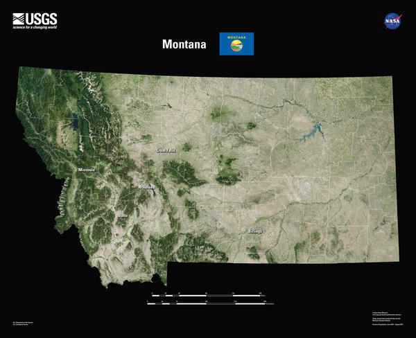
Montana Landsat State Mosaic
Cattle roam and forage across Montana’s wide-open spaces, with the beef
industry fueling the State’s economy. Landsat data are used to help guide
decisions on invasive species management, like controlling cheatgrass. Montana
researchers also use Landsat satellite data to map persistent snow and ice cover
in Glacier National Park.
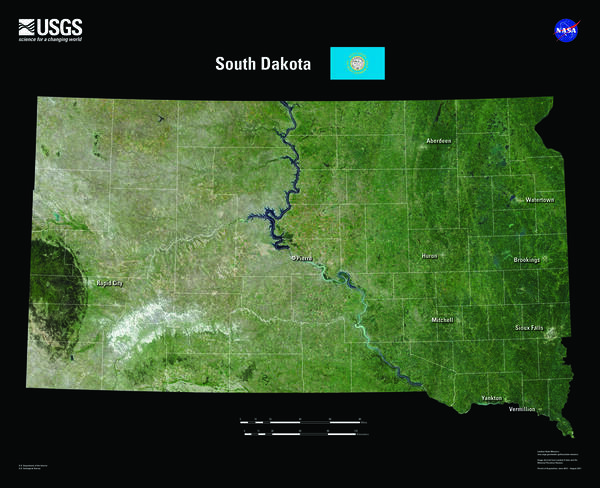
South Dakota Landsat State Mosaic
South Dakota is home to the fabled “Black Hills.” Seen from a distance, these pine-covered hills, rising several thousand feet above the surrounding prairie, appear black.
Capital Pierre
Image Source Landsat 8
Population 886,667
South Dakota is home to the fabled “Black Hills.” Seen from a distance, these pine-covered hills, rising several thousand feet above the surrounding prairie, appear black.
Capital Pierre
Image Source Landsat 8
Population 886,667
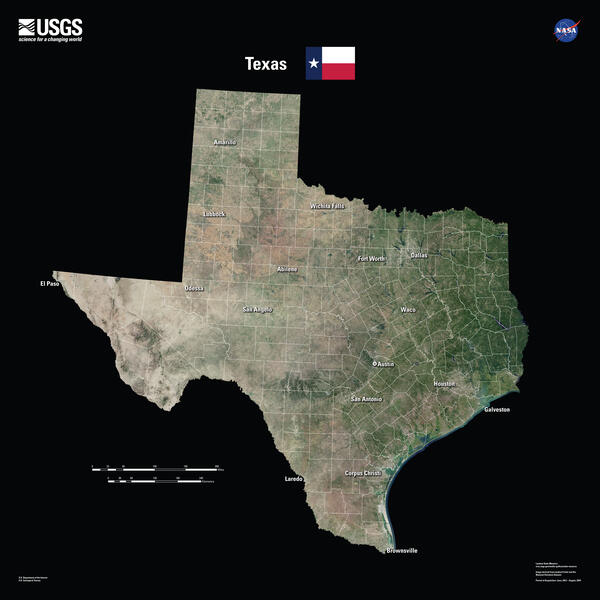
Texas Landsat State Mosaic
Tourists are drawn to the Texas coastline, but it is a frequent target of hurricanes.
Landsat documents storm damage and long-term coastal changes. Landsat data
are also used to study the urban heat island effect, helping communities identify
hotspots where human lives are at risk of heat-related illnesses. Because nearly

Gypsy Moth Infestation Continues in New England
A large outbreak of gypsy moth (Lymantria dispar) caterpillars attacked the hardwood forests of the northeastern United States in 2016. A fungus (Entomophaga maimaigaM) introduced from Japan has kept gypsy moth populations at relatively low levels since the late 1980s.
A large outbreak of gypsy moth (Lymantria dispar) caterpillars attacked the hardwood forests of the northeastern United States in 2016. A fungus (Entomophaga maimaigaM) introduced from Japan has kept gypsy moth populations at relatively low levels since the late 1980s.
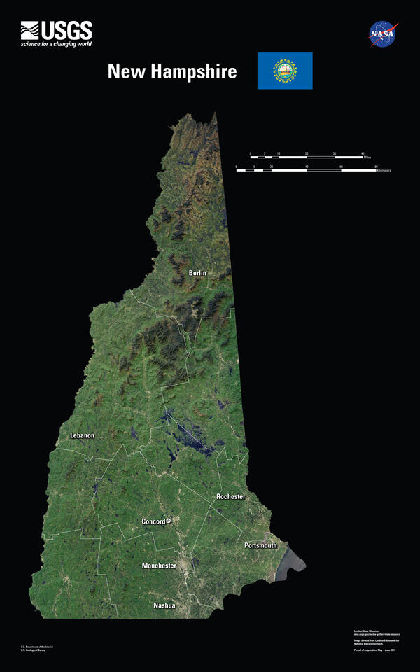
New Hampshire Landsat State Mosaic
In 1934, the summit of Mount Washington in New Hampshire’s White Mountains experienced a wind gust of 231 miles per hour, the highest surface wind speed ever recorded.
Capital Concord
Image Source Landsat 8
Population 1,377,529
In 1934, the summit of Mount Washington in New Hampshire’s White Mountains experienced a wind gust of 231 miles per hour, the highest surface wind speed ever recorded.
Capital Concord
Image Source Landsat 8
Population 1,377,529

Understory - EROS LiDAR
Example of lidar-derived metric products of canopy structure. A) Image showing an area characterized by varied forest strands. (Red box shows from where profile data in E area taken.) B) Lidar-derived maximum canopy height. C) Lidar-derived height of low- to medium-height vegetation beneath the overstory canopy.
Example of lidar-derived metric products of canopy structure. A) Image showing an area characterized by varied forest strands. (Red box shows from where profile data in E area taken.) B) Lidar-derived maximum canopy height. C) Lidar-derived height of low- to medium-height vegetation beneath the overstory canopy.

Superior National Forest - EROS LiDAR
A profile view from the normalized point cloud in Superior National Forest, notice the flattened ground surface. Points are colored by elevation.
A profile view from the normalized point cloud in Superior National Forest, notice the flattened ground surface. Points are colored by elevation.

Southern California Wildfires Update
Santa Ana winds rapidly spread wildfires through shrubland, tall grasses, and brush in southern California in December 2017. As of January 2, 2018, the Thomas Fire burned 281,893 acres since starting on December 4. The fire is almost entirely contained, but not before becoming the largest fire in California’s modern history.
Santa Ana winds rapidly spread wildfires through shrubland, tall grasses, and brush in southern California in December 2017. As of January 2, 2018, the Thomas Fire burned 281,893 acres since starting on December 4. The fire is almost entirely contained, but not before becoming the largest fire in California’s modern history.

Weird Watercolor
Green shades seem to be bubbling up like a lava lamp on the left side of this image from northeastern Kenya. The right side is like rusted metal. The dark green is the result of geologically recent lava flows, and the other colors are different types of soils. Even with few defined shapes, the piece has a strange beauty.
Green shades seem to be bubbling up like a lava lamp on the left side of this image from northeastern Kenya. The right side is like rusted metal. The dark green is the result of geologically recent lava flows, and the other colors are different types of soils. Even with few defined shapes, the piece has a strange beauty.

Tapestry
Soft colors contrast with harsh terrain in southwestern Saudi Arabia, near the border with Yemen. Calming blues and purples seem to collide with an angry orange in this rich tapestry of colors, which are the result of the region’s complex geology. The wild shapes in this busy landscape lie in a region known as the Asharah fault zone.
Soft colors contrast with harsh terrain in southwestern Saudi Arabia, near the border with Yemen. Calming blues and purples seem to collide with an angry orange in this rich tapestry of colors, which are the result of the region’s complex geology. The wild shapes in this busy landscape lie in a region known as the Asharah fault zone.

Fanciful Fluorescence
Fluorescent colors dominate this dreamlike scene. The orange shapes look like glowfish in a fanciful underwater world. Those glowfish are actually clouds, and the neon green represents mountains, including Mount Rainier, near Seattle, Washington.
Fluorescent colors dominate this dreamlike scene. The orange shapes look like glowfish in a fanciful underwater world. Those glowfish are actually clouds, and the neon green represents mountains, including Mount Rainier, near Seattle, Washington.

Expressions in the Desert
In a remote part of the Western Desert in central Egypt, highly eroded plateaus rise from the desert floor. The bright speckles are ancient dry lakes, the salt deposits reflecting brightly. Long ago, water flowed off the plateau, forming the breaches seen on the plateaus’ edges. This desolate land between oases is surrounded by extensive sand dunes.
In a remote part of the Western Desert in central Egypt, highly eroded plateaus rise from the desert floor. The bright speckles are ancient dry lakes, the salt deposits reflecting brightly. Long ago, water flowed off the plateau, forming the breaches seen on the plateaus’ edges. This desolate land between oases is surrounded by extensive sand dunes.

Moody Carvings
These orange shades and ragged shapes give an impression of moodiness. The jagged scars are extensive valleys carved by water flowing from the Andes Mountains in northern Chile. The crater in the lower right is the volcano Cerro Guachiscota.
These orange shades and ragged shapes give an impression of moodiness. The jagged scars are extensive valleys carved by water flowing from the Andes Mountains in northern Chile. The crater in the lower right is the volcano Cerro Guachiscota.

Painted Horse
The northern end of Isla Isabela in the Galapagos looks like a seahorse with warts—with an eye painted in the ancient Egyptian style. The island was formed by the merger of six volcanoes. Wolf Volcano is the prominent one in the center; Ecuador Volcano is the one that forms the seahorse’s mouth. Past volcanic flows radiate from the large craters.
The northern end of Isla Isabela in the Galapagos looks like a seahorse with warts—with an eye painted in the ancient Egyptian style. The island was formed by the merger of six volcanoes. Wolf Volcano is the prominent one in the center; Ecuador Volcano is the one that forms the seahorse’s mouth. Past volcanic flows radiate from the large craters.

Hurricane Sandy's Lasting Effects on Fire Island, NY
Hurricane Sandy's Lasting Effects on Fire Island, NYAs Hurricane Sandy made landfall on October 29, 2012, the storm’s waves and wind cut a breach in a narrow part of Fire Island, a barrier island south of Long Island, New York.
Hurricane Sandy's Lasting Effects on Fire Island, NY
Hurricane Sandy's Lasting Effects on Fire Island, NYAs Hurricane Sandy made landfall on October 29, 2012, the storm’s waves and wind cut a breach in a narrow part of Fire Island, a barrier island south of Long Island, New York.

Wildfires Devastate California Wine Country
Residents had little warning when wildfires that ignited late Sunday night, October 8, 2017, were fanned by wind gusts of 50 miles per hour and blasted across California's wine country. More than 100,000 acres have burned as of October 11, with less than 6 percent of the fires contained.
Residents had little warning when wildfires that ignited late Sunday night, October 8, 2017, were fanned by wind gusts of 50 miles per hour and blasted across California's wine country. More than 100,000 acres have burned as of October 11, with less than 6 percent of the fires contained.

Lurking Madness
This Landsat image looks like a bold watercolor. Yellow dances across the darkness with muted violet underneath. With a kind of science-fiction flair, this scene shows a portion of the Qattara Depression in Egypt.
This Landsat image looks like a bold watercolor. Yellow dances across the darkness with muted violet underneath. With a kind of science-fiction flair, this scene shows a portion of the Qattara Depression in Egypt.


Pine Island Glacier’s Newest Iceberg
Pine Island Glacier in Antarctica has snapped off its share of icebergs in recent years. The frequency of noteworthy breaks is evidence that the ice shelf is becoming increasingly fragile. The latest iceberg cracked off the end of the Pine Island Glacier ice shelf around September 23, 2017.
Pine Island Glacier in Antarctica has snapped off its share of icebergs in recent years. The frequency of noteworthy breaks is evidence that the ice shelf is becoming increasingly fragile. The latest iceberg cracked off the end of the Pine Island Glacier ice shelf around September 23, 2017.

Boat on Kootenai River
A boat moves off the banks of the Kootenai River in northern Idaho. Researchers from USGS EROS conducted topobathymetry surveys of the river in 2017 using LiDAR and sonar equipment.
A boat moves off the banks of the Kootenai River in northern Idaho. Researchers from USGS EROS conducted topobathymetry surveys of the river in 2017 using LiDAR and sonar equipment.

GPS device on Kootenai River
A GPS device on the banks of the Kootenai River of northern Idaho, where USGS EROS researchers conducted topobathymetry surveys in 2017 using LiDAR and sonar equipment.A GPS device on the banks of the Kootenai River of northern Idaho, where USGS EROS researchers conducted topobathymetry surveys in 2017 using LiDAR and sonar equipment.
A GPS device on the banks of the Kootenai River of northern Idaho, where USGS EROS researchers conducted topobathymetry surveys in 2017 using LiDAR and sonar equipment.A GPS device on the banks of the Kootenai River of northern Idaho, where USGS EROS researchers conducted topobathymetry surveys in 2017 using LiDAR and sonar equipment.