
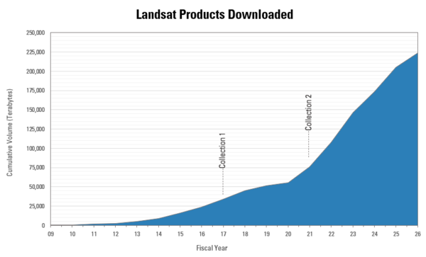
This graphic displays the cumulative volume of all operational Landsat products downloaded from the USGS EROS Landsat archive since December 2008 (FY2009). The release of Landsat Collection 2 products in 2020, which improved data quality and accessibility, helped drive downloads upward.
Multimedia
See our Imagery
EROS is home to a wide variety of remotely sensed imagery. Our galleries include some of our best
EROS is home to a wide variety of remotely sensed imagery. Our galleries include some of our best
Before and After
Use our interactive image comparison sliders to see change over time
Use our interactive image comparison sliders to see change over time
Earthshots
See images and read stories about some of the world's most fascinating Earth surface change
See images and read stories about some of the world's most fascinating Earth surface change
We maintain collections of images and videos that are available for download at no charge. Follow the links below to explore our multimedia.
Earth As Art
Earth As Art

In addition to their scientific value, many satellite images are simply intriguing to look at. Satellites capture an incredible variety of views of Earth. See the mesmerizing beauty of river deltas, mountains, and other sandy, salty, and icy landscapes.
Landsat State Mosaics
Landsat State Mosaics
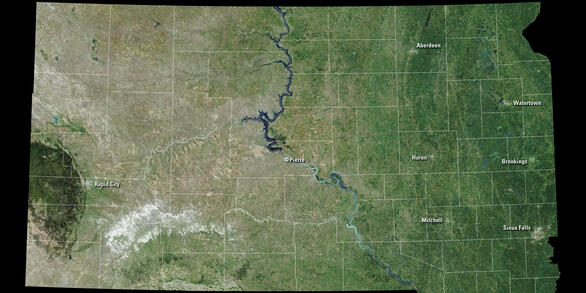
A view of all 50 states from space. The images combine multiple Landsat scenes to showcase each state’s unique landscapes, from expansive forests and arid deserts to bustling cities and serene coastlines.
Landsat in Action
Landsat in Action
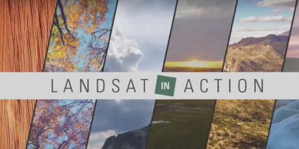
Watch Landsat Science Team members and researchers from around the world talk about the value of remotely sensed imagery to monitoring the health of the planet.
Images
Landsat Product Downloads by Volume
This graphic displays the cumulative volume of all operational Landsat products downloaded from the USGS EROS Landsat archive since December 2008 (FY2009). The release of Landsat Collection 2 products in 2020, which improved data quality and accessibility, helped drive downloads upward.
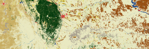
2025 Annual NLCD land cover image of western South Dakota
2025 Annual NLCD land cover image of western South DakotaThis 2025 Annual National Land Cover Database (NLCD) land cover image shows a portion of western South Dakota. The Black Hills stand out in green, and the urban area of Rapid City in red at its eastern edge. The Badlands show up as gray hues, and vast range and grasslands fill the area leading over to the Missouri River.
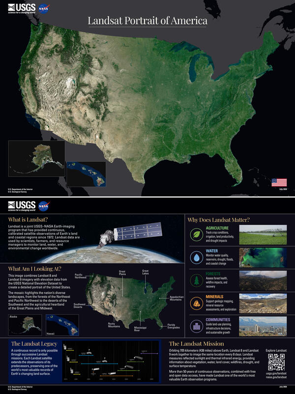
Landsat Portrait of America
The complete Landsat Portrait of America poster, shown with the front on top and the back below.
The complete Landsat Portrait of America poster, shown with the front on top and the back below.
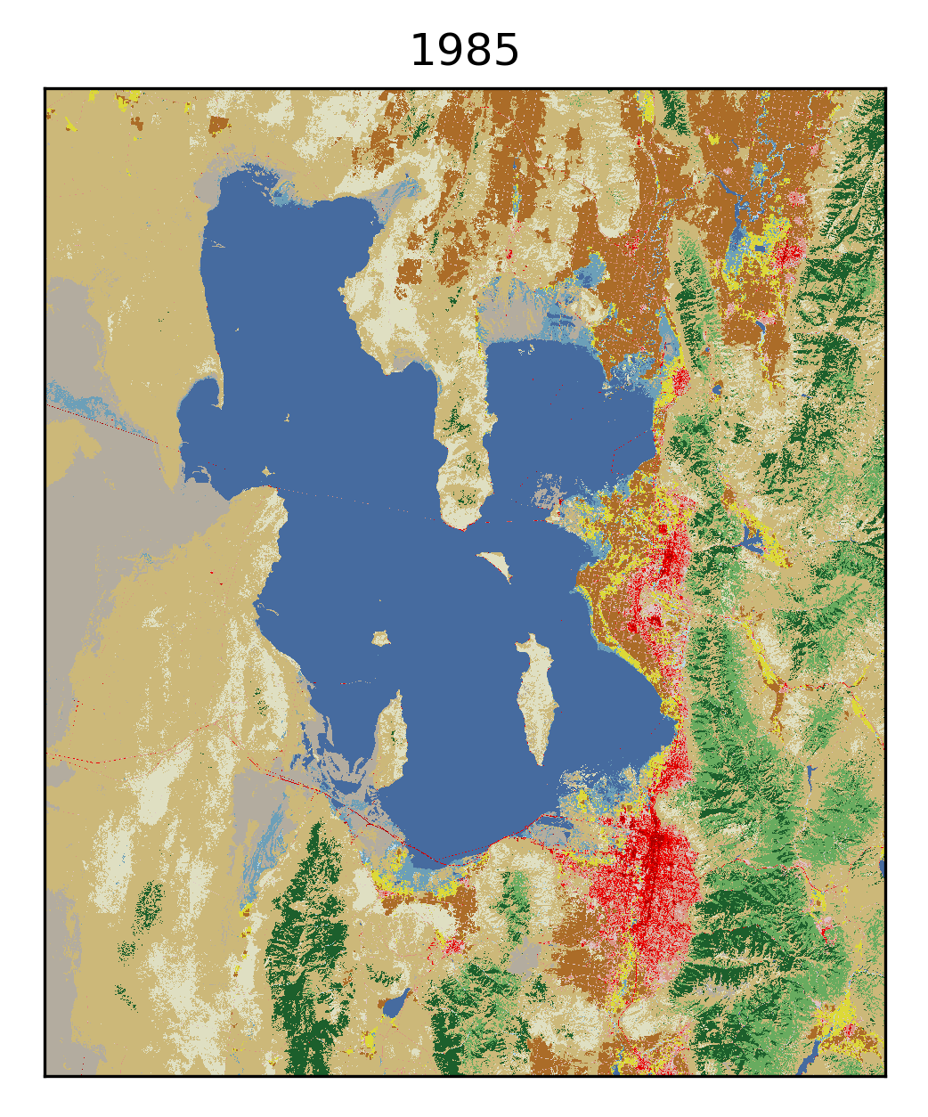
Annual NLCD animation of the Great Salt Lake area from 1985 to 2025
Annual NLCD animation of the Great Salt Lake area from 1985 to 2025This Annual National Land Cover Database (NLCD) animation shows the Great Salt Lake area in Utah from 1985 to 2025. Darker blue represents open water, while lighter blues represent wetlands. Shades of green signify various types of forests. Shades of red are developed cities and roads, with darker shades indicating more intense areas of development.
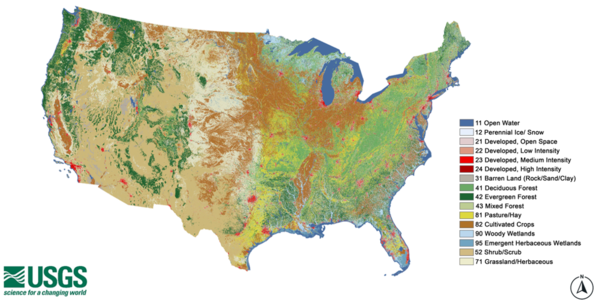
Annual NLCD map of the United States with legend
Annual National Land Cover Database (NLCD) map of the United States with classifications for types of land cover. Produced by the USGS Earth Resources Observation and Science (EROS) Center.
Annual National Land Cover Database (NLCD) map of the United States with classifications for types of land cover. Produced by the USGS Earth Resources Observation and Science (EROS) Center.
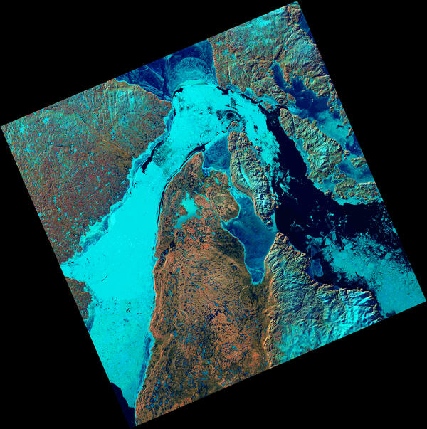
Ice Fills Roes Welcome Sound
The Landsat 8 satellite captured an image showing sea ice packed into Roes Welcome Sound, located along the northwestern edge of Southampton Island and around Qikiqtaaluk Island in the uninhabited Canadian Arctic Archipelago. East of Qikiqtaaluk, ice drifts through the Frozen Strait, extending eastward into Foxe Basin.
The Landsat 8 satellite captured an image showing sea ice packed into Roes Welcome Sound, located along the northwestern edge of Southampton Island and around Qikiqtaaluk Island in the uninhabited Canadian Arctic Archipelago. East of Qikiqtaaluk, ice drifts through the Frozen Strait, extending eastward into Foxe Basin.
Videos
 Tool Demo")
MRLC Enhanced Visualization and Analysis (EVA) Tool Demo
MRLC Enhanced Visualization and Analysis (EVA) Tool DemoThis video is a demonstration of the EVA Tool. It was conducted during the January 20, 2026 webinar. To watch the full webinar please visit: https://www.usgs.gov/media/videos/visualizing-land-cover-mrlc-tools.

How to Use USGS EarthExplorer to Download Imagery
This video covers EarthExplorer, or EE, which allows users to search for satellite and aerial imagery, preview browse images, export metadata, and download earth science data from the archives of the U.S. Geological Survey (USGS) Earth Resources Observation and Science (EROS) center.
This video covers EarthExplorer, or EE, which allows users to search for satellite and aerial imagery, preview browse images, export metadata, and download earth science data from the archives of the U.S. Geological Survey (USGS) Earth Resources Observation and Science (EROS) center.

JACIE: Joint Agency Commercial Imagery Evaluation
The Joint Agency Commercial Imagery Evaluation, better known as JACIE, was created to bring together the strengths of multiple Federal agencies.
Its mission is simple, yet essential, to evaluate remote sensing data, and share those insights with the entire remote sensing community.
The Joint Agency Commercial Imagery Evaluation, better known as JACIE, was created to bring together the strengths of multiple Federal agencies.
Its mission is simple, yet essential, to evaluate remote sensing data, and share those insights with the entire remote sensing community.

Landsat Special Requests: Expanding Acquisition Capabilities
Landsat Special Requests: Expanding Acquisition CapabilitiesThis video is a recording of a previous webinar entitled: “Landsat Special Requests: Expanding Acquisition Capabilities”. This webinar was recorded on April 16, 2026.
Landsat Special Requests: Expanding Acquisition Capabilities
Landsat Special Requests: Expanding Acquisition CapabilitiesThis video is a recording of a previous webinar entitled: “Landsat Special Requests: Expanding Acquisition Capabilities”. This webinar was recorded on April 16, 2026.

Introducing ASTER Version 4: What's New in Data Access, Products, Formats, and How to Unlock the ASTER Cloud Archive
Introducing ASTER Version 4: What's New in Data Access, Products, Formats, and How to Unlock the ASTER Cloud ArchiveThis video is a recording of a previous webinar entitled: “Introducing ASTER Version 4: What’s New in Data Access, Products, Formats, and How to Unlock the ASTER Cloud Archive”. This webinar was recorded on April 2, 2026.

Guess the Location with Landsat
Can you guess the locations of these mystery Landsat images?
Landsat satellites capture images of the Earth’s surface and help scientists study resource management, investigate land surface change, and support disaster response.
Can you guess the locations of these mystery Landsat images?
Landsat satellites capture images of the Earth’s surface and help scientists study resource management, investigate land surface change, and support disaster response.
Audio
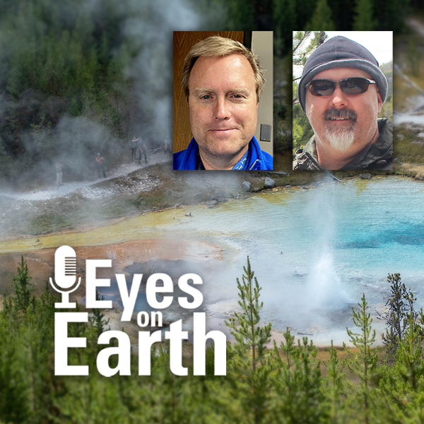
Eyes on Earth Episode 137 – Landsat Takes Yellowstone’s Temperature
Eyes on Earth Episode 137 – Landsat Takes Yellowstone’s TemperatureThe Yellowstone National Park area has more than 10,000 thermal features. And while Old Faithful is a pretty predictable geyser, some thermal features can change quite a bit. New ones can even pop up! Remote sensing provides a tool for monitoring them—especially the thermal infrared sensors (TIRS) on Landsat 8 and Landsat 9 satellites.
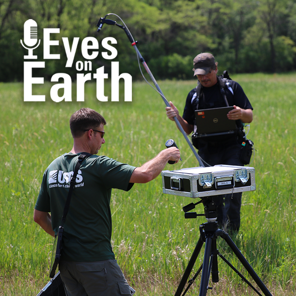
Eyes on Earth Episode 136 – The EROS Test Site
Landsat has been accurate and reliable for over 50 years because of the diligent calibration and validation work done by the team at EROS. One of the ways the team validates what they have so carefully calibrated is to take measurements on the ground while Landsat passes by overhead.
Landsat has been accurate and reliable for over 50 years because of the diligent calibration and validation work done by the team at EROS. One of the ways the team validates what they have so carefully calibrated is to take measurements on the ground while Landsat passes by overhead.

Eyes on Earth Episode 135 – Exotic Annual Grasses and Sheep Grazing
Eyes on Earth Episode 135 – Exotic Annual Grasses and Sheep GrazingExotic annual grasses, or EAGs, are invasive species. They outcompete native grasses. They are extremely flammable. And they are expanding into higher elevations. Targeted sheep grazing is one way to combat these invasive grasses, manage fire risk, and help restore native sagebrush in western states.

Eyes on Earth Episode 134 – Data Accuracy: The Calibration and Validation of Landsat
Eyes on Earth Episode 134 – Data Accuracy: The Calibration and Validation of LandsatLandsat is the longest-running, continuously operating record of Earth observations, and it’s the gold standard reference point that other civil and commercial satellite programs trust.

Eyes on Earth Episode 133 – Vietnam War Bomb Craters
Eyes on Earth Episode 133 – Vietnam War Bomb CratersDeclassified spy satellite imagery, distributed by the USGS EROS Center, is finding fascinating uses since being made available to the public starting in the 1990s.
Eyes on Earth Episode 133 – Vietnam War Bomb Craters
Eyes on Earth Episode 133 – Vietnam War Bomb CratersDeclassified spy satellite imagery, distributed by the USGS EROS Center, is finding fascinating uses since being made available to the public starting in the 1990s.

Eyes on Earth Episode 132 - Moving Forward with AI at EROS
Eyes on Earth Episode 132 - Moving Forward with AI at EROSEyes on Earth tackles artificial intelligence (AI) in a 2-part episode. AI is quickly becoming a necessary part of geospatial work at EROS, helping us efficiently do science to better manage our world. In Part 1, we talked about AI’s current and upcoming impact on our work at EROS and clarified some of the AI jargon.