
Meandering wadis combine to form dense, branching networks across the stark, arid landscape of southeastern Jordan. The Arabic word "wadi" means a gulley or streambed that typically remains dry except after drenching, seasonal rains.
Images
Peruse our selection of remote sensing and Earth science imagery below.
Filter Total Items: 870

Jordan
Meandering wadis combine to form dense, branching networks across the stark, arid landscape of southeastern Jordan. The Arabic word "wadi" means a gulley or streambed that typically remains dry except after drenching, seasonal rains.

Whirlpool in the Air
This image shows a spinning formation of ice, clouds, and low-lying fog off the eastern coast of Greenland.
This image shows a spinning formation of ice, clouds, and low-lying fog off the eastern coast of Greenland.

Rugged Terrain
Hues of green and orange highlight the extreme ruggedness of the mountainous terrain in eastern Afghanistan, near its border with Pakistan. The dark green areas on the right side along rivers indicate agricultural areas. Snow-fed streams allow sufficient irrigation to transform relatively arid soils into productive fields.
Hues of green and orange highlight the extreme ruggedness of the mountainous terrain in eastern Afghanistan, near its border with Pakistan. The dark green areas on the right side along rivers indicate agricultural areas. Snow-fed streams allow sufficient irrigation to transform relatively arid soils into productive fields.

Waziristan Hills
Deep purple and green hues enhance the Waziristan Hills, a mountainous region of northwest Pakistan near the Afghanistan border. A formidable landscape, the Waziristan Hills are a hodgepodge of steep, rugged hills split by narrow passes and deep gorges. Rivers coursing down from the mountains provide water for agriculture in a region of scanty rainfall.
Deep purple and green hues enhance the Waziristan Hills, a mountainous region of northwest Pakistan near the Afghanistan border. A formidable landscape, the Waziristan Hills are a hodgepodge of steep, rugged hills split by narrow passes and deep gorges. Rivers coursing down from the mountains provide water for agriculture in a region of scanty rainfall.

Great Salt Desert
Like swirls of paint on an enormous canvas, shallow lakes, mudflats, and salt marshes share the sinuous valleys on Iran's largely uninhabited Dasht-e Kavir, or Great Salt Desert.
Like swirls of paint on an enormous canvas, shallow lakes, mudflats, and salt marshes share the sinuous valleys on Iran's largely uninhabited Dasht-e Kavir, or Great Salt Desert.

Sulaiman Mountains
The Sulaiman Mountains are a major geological feature of Pakistan and one of the bordering ranges of the Indian subcontinent.
The Sulaiman Mountains are a major geological feature of Pakistan and one of the bordering ranges of the Indian subcontinent.

National Aerial Photography Program (NAPP) - Little Rock, AR - CIR
National Aerial Photography Program (NAPP) - Little Rock, AR - CIRNational Aerial Photography Program (NAPP) - Little Rock, AR - Color Infrad - March 25, 2001
National Aerial Photography Program (NAPP) - Little Rock, AR - CIR
National Aerial Photography Program (NAPP) - Little Rock, AR - CIRNational Aerial Photography Program (NAPP) - Little Rock, AR - Color Infrad - March 25, 2001

The Dardzha Monster
Looking like a monstrous ogre with something gooey in its mouth, the Dardzha Peninsula in western Turkmenistan lies among the shallow coastal terraces of the Caspian Sea. Strong winds create huge sand dunes near the water, some of which are partly submerged. Further inland, the dunes transition to low sand plains.
Looking like a monstrous ogre with something gooey in its mouth, the Dardzha Peninsula in western Turkmenistan lies among the shallow coastal terraces of the Caspian Sea. Strong winds create huge sand dunes near the water, some of which are partly submerged. Further inland, the dunes transition to low sand plains.

Great Sandy Desert
The western region of Australia's Great Sandy Desert is an area almost devoid of sand, but characterized by complex geology.
The western region of Australia's Great Sandy Desert is an area almost devoid of sand, but characterized by complex geology.

Akpatok Island
Akpatok Island lies in Ungava Bay in northern Quebec, Canada. Accessible only by air, Akpatok Island rises out of the water as sheer cliffs that soar 500 to 800 feet (150 to 243m) above the sea surface. The island is an important sanctuary for cliff-nesting seabirds.
Akpatok Island lies in Ungava Bay in northern Quebec, Canada. Accessible only by air, Akpatok Island rises out of the water as sheer cliffs that soar 500 to 800 feet (150 to 243m) above the sea surface. The island is an important sanctuary for cliff-nesting seabirds.

Richat Structure
The so-called Richat Structure is a geological formation in the Maur Adrar Desert in the African country of Mauritania. Although it resembles an impact crater, the Richat Structure formed when a volcanic dome hardened and gradually eroded, exposing the onion-like layers of rock.
The so-called Richat Structure is a geological formation in the Maur Adrar Desert in the African country of Mauritania. Although it resembles an impact crater, the Richat Structure formed when a volcanic dome hardened and gradually eroded, exposing the onion-like layers of rock.

Iraqi Emplacement
In an area north of the city of Al-Basrah, Iraq, which borders Iran, a former wetland has been drained and walled off. Now littered with minefields and gun emplacements, it is a staging area for military exercises.
In an area north of the city of Al-Basrah, Iraq, which borders Iran, a former wetland has been drained and walled off. Now littered with minefields and gun emplacements, it is a staging area for military exercises.

Desolation Canyon
Utah’s Green River flows south across the Tavaputs Plateau (top) before entering Desolation Canyon (center). The Canyon slices through the Roan and Book Cliff--two long, staircase-like escarpments. Nearly as deep as the Grand Canyon, Desolation Canyon is one of the largest unprotected wilderness areas in the American West.
Utah’s Green River flows south across the Tavaputs Plateau (top) before entering Desolation Canyon (center). The Canyon slices through the Roan and Book Cliff--two long, staircase-like escarpments. Nearly as deep as the Grand Canyon, Desolation Canyon is one of the largest unprotected wilderness areas in the American West.

Center-pivot irrigation in Saudi Arabia captured by Landsat 7, 2000
Center-pivot irrigation in Saudi Arabia captured by Landsat 7, 2000Landsat 7 captured this image of center-pivot irrigation (green circles) in the Saudi Arabian desert in 2000. Images taken of the same location over several decades show the explosive increase of irrigated land over time, as hidden reserves of water have been tapped beneath desert sands to grow grains, fruits, and vegetables.
Landsat 7 Image of Eyjabakkajökull Glacier
This Landsat image displays the Eyjabakkajökull Glacier, an outlet glacier of the Vatnajökull ice cap in Iceland. (N64.6756, W15.5843)
Landsat 7 Path 216 Row 15
Acquired September 16, 2000
This Landsat image displays the Eyjabakkajökull Glacier, an outlet glacier of the Vatnajökull ice cap in Iceland. (N64.6756, W15.5843)
Landsat 7 Path 216 Row 15
Acquired September 16, 2000

Robinson Glacier
Lines and shapes etched into the surface of Antarctica's Robinson Glacier hint at the slow but inevitable movements of this giant river of ice. Patterns of lines may be icefalls, where a glacier cascades over rock, or a series of crevasses, massive cracks that form as different parts of a glacier move at slightly different speeds.
Lines and shapes etched into the surface of Antarctica's Robinson Glacier hint at the slow but inevitable movements of this giant river of ice. Patterns of lines may be icefalls, where a glacier cascades over rock, or a series of crevasses, massive cracks that form as different parts of a glacier move at slightly different speeds.

Lambert Glacier
The Lambert Glacier in Antarctica is the world's largest glacier. The focal point of this image is an icefall that feeds into the glacier from the vast ice sheet covering the polar plateau. Ice flows like water, albeit much more slowly.
The Lambert Glacier in Antarctica is the world's largest glacier. The focal point of this image is an icefall that feeds into the glacier from the vast ice sheet covering the polar plateau. Ice flows like water, albeit much more slowly.

Guinea-Bissau
Guinea-Bissau is a small country in West Africa. Complex patterns can be seen in the shallow waters along its coastline, where silt carried by the Geba and other rivers washes out into the Atlantic Ocean.
Guinea-Bissau is a small country in West Africa. Complex patterns can be seen in the shallow waters along its coastline, where silt carried by the Geba and other rivers washes out into the Atlantic Ocean.

Ghadamis River
This scar on an arid landscape is the dry riverbed of the Ghadamis River in the Tinrhert Hamada Mountains near Ghadamis, Libya.
This scar on an arid landscape is the dry riverbed of the Ghadamis River in the Tinrhert Hamada Mountains near Ghadamis, Libya.

Dasht-e Kevir
The Dasht-e Kevir, or Great Salt Desert, is the largest desert in Iran. It is a primarily uninhabited wasteland, composed of mud and salt marshes covered with crusts of salt that protect the meager moisture from completely evaporating.
The Dasht-e Kevir, or Great Salt Desert, is the largest desert in Iran. It is a primarily uninhabited wasteland, composed of mud and salt marshes covered with crusts of salt that protect the meager moisture from completely evaporating.

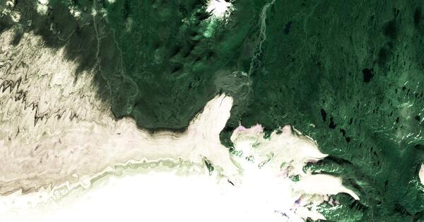
Mayn River
The Mayn River, seen here with what is thought to be a portion of the Anadyr River, flows through the far northeastern corner of Siberia.
The Mayn River, seen here with what is thought to be a portion of the Anadyr River, flows through the far northeastern corner of Siberia.