
Sacramento Mountains checkerspot butterfly, found only in sunny meadows within the Sacramento Mountains of southern New Mexico.
Multimedia
Images

Sacramento Mountains checkerspot butterfly
Sacramento Mountains checkerspot butterfly, found only in sunny meadows within the Sacramento Mountains of southern New Mexico.
Sacramento Mountains checkerspot butterfly
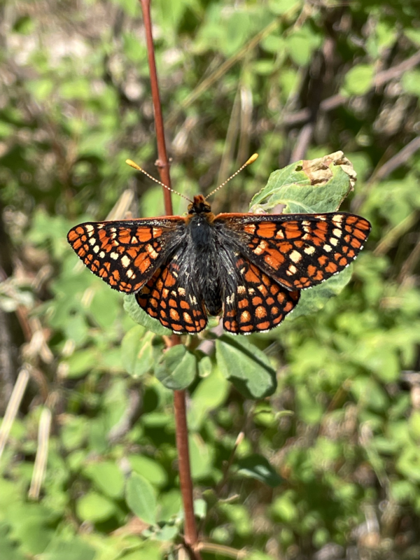
The stunning orange and dark-brown butterfly is found only in high-elevation meadows in the Lincoln National Forest in southern New Mexico.
The stunning orange and dark-brown butterfly is found only in high-elevation meadows in the Lincoln National Forest in southern New Mexico.
Desert striped whipsnake
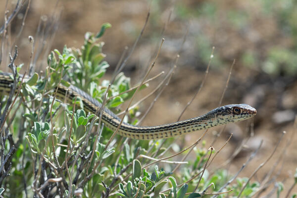
A slender Desert Striped Whipsnake - coluber taeniatus.
A slender Desert Striped Whipsnake - coluber taeniatus.
Testing a thermal infrared camera by capturing water surface temperature off the side of a bridge in Seattle, Washington
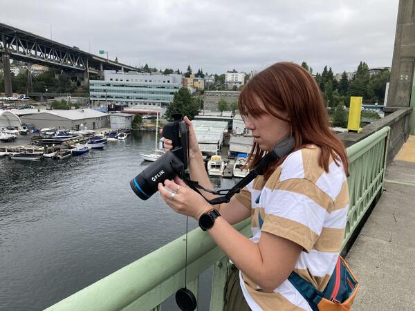
Testing a thermal infrared camera by capturing water surface temperature off the side of a bridge in Seattle, WashingtonPhoto of EAE testing and adjusting the forward-looking infrared (FLIR) camera parameters while directing the sensor at the water surface off the side of a bridge in Seattle, Washington.
Testing a thermal infrared camera by capturing water surface temperature off the side of a bridge in Seattle, Washington
Testing a thermal infrared camera by capturing water surface temperature off the side of a bridge in Seattle, WashingtonPhoto of EAE testing and adjusting the forward-looking infrared (FLIR) camera parameters while directing the sensor at the water surface off the side of a bridge in Seattle, Washington.
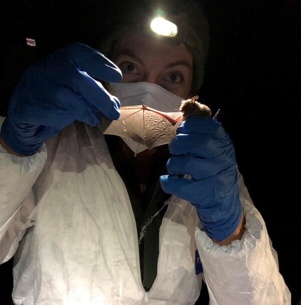
Setting up to collect samples from a bat
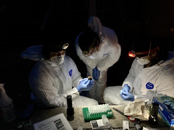
Scientists get ready to collect samples from a bat to test for Pseudogymnoascus destructans, the fungus that causes white-nose syndrome.
Scientists get ready to collect samples from a bat to test for Pseudogymnoascus destructans, the fungus that causes white-nose syndrome.
Looking for wing damage
Scientists look for damage on the skin of a bat's wing as an indicator of white-nose syndrome infection. This bat has no wing damage.
Scientists look for damage on the skin of a bat's wing as an indicator of white-nose syndrome infection. This bat has no wing damage.
Videos

Saline Lake Ecosystems IWAA Spring Seminar: Project Updates and 2026 Field Season Plans
Saline Lake Ecosystems IWAA Spring Seminar: Project Updates and 2026 Field Season PlansThis video presents the Spring 2026 Saline Lake Ecosystems Integrated Water Availability Assessment Spring Seminar by the U.S. Geological Survey (USGS). Narrated by Lisa Hoaks, the seminar provides project updates, summer 2026 field season plans, and recently published products.

Saline Lake Ecosystems IWAA Spring Seminar: Project Updates and 2025 Field Season Plans
Saline Lake Ecosystems IWAA Spring Seminar: Project Updates and 2025 Field Season PlansThis video presents the Spring 2025 Saline Lake Ecosystems Integrated Water Availability Assessment Spring Seminar by the U.S. Geological Survey (USGS). Hosted by Allison Shipp, the seminar provides updates on how hydroclimatic changes and water management affect terminal lake ecosystems and waterbird populations.

Saline Lakes IWAA Fall 2024 Webinar Series: Satellite Observations of Lake Surface Water Dynamics
Saline Lakes IWAA Fall 2024 Webinar Series: Satellite Observations of Lake Surface Water DynamicsThe sixth and final webinar in the Saline Lakes Ecosystems IWAA Fall 2024 Webinar Series is on satellite observations of lake surface water dynamics. John W. Jones of the USGS Hydrologic Remote Sensing Branch introduces the surface water and wetland remote sensing component of the Integrated Water Availability Assessment.
By
Ecosystems Mission Area, Water Resources Mission Area, Species Management Research Program, Water Availability and Use Science Program, Forest and Rangeland Ecosystem Science Center, Fort Collins Science Center, Nevada Water Science Center, Oregon Water Science Center, Utah Water Science Center, Western Ecological Research Center (WERC), Saline Lake Ecosystems Integrated Water Availability Assessment

Saline Lakes IWAA Fall 2024 Webinar Series: Waterbird Prey Availability
Saline Lakes IWAA Fall 2024 Webinar Series: Waterbird Prey AvailabilityThe fifth webinar in the Saline Lakes Ecosystems IWAA Fall 2024 Webinar Series is on waterbird prey availability in Great Basin terminal lakes.
By
Ecosystems Mission Area, Water Resources Mission Area, Species Management Research Program, Water Availability and Use Science Program, Forest and Rangeland Ecosystem Science Center, Fort Collins Science Center, Nevada Water Science Center, Oregon Water Science Center, Utah Water Science Center, Western Ecological Research Center (WERC), Saline Lake Ecosystems Integrated Water Availability Assessment

Saline Lakes Ecosystems IWAA Fall 2024 Webinar Series: Bird Movements
Saline Lakes Ecosystems IWAA Fall 2024 Webinar Series: Bird MovementsThe fourth webinar in the Saline Lakes Ecosystems IWAA Fall 2024 Webinar Series is on movement of bird species associated with Great Basin terminal lake ecosystems. Cory Overton of the Western Ecological Research Center gives an overview of the USGS bird movement monitoring strategy and presents results from the 2024 field season.
By
Ecosystems Mission Area, Water Resources Mission Area, Species Management Research Program, Water Availability and Use Science Program, Forest and Rangeland Ecosystem Science Center, Fort Collins Science Center, Nevada Water Science Center, Oregon Water Science Center, Utah Water Science Center, Western Ecological Research Center (WERC), Saline Lake Ecosystems Integrated Water Availability Assessment

Saline Lakes Ecosystems IWAA Fall 2024 Webinar Series: Water-Quality Monitoring of Great Basin Terminal Lake Ecosystems
Saline Lakes Ecosystems IWAA Fall 2024 Webinar Series: Water-Quality Monitoring of Great Basin Terminal Lake EcosystemsThe third webinar in the Saline Lakes Ecosystems IWAA Fall 2024 Webinar Series is on water-quality monitoring of Great Basin terminal lake ecosystems. Christine Rumsey of the Utah Water Science Center and Casie Smith of the Oregon Water Science Center give an overview of the USGS water-quality monitoring strategy and present results from the 2024 field season.
By
Ecosystems Mission Area, Water Resources Mission Area, Species Management Research Program, Water Availability and Use Science Program, Forest and Rangeland Ecosystem Science Center, Fort Collins Science Center, Nevada Water Science Center, Oregon Water Science Center, Utah Water Science Center, Western Ecological Research Center (WERC), Saline Lake Ecosystems Integrated Water Availability Assessment
Audio

Who's Your Mama? Conservation Genetics and At-Risk Species
Who's Your Mama? Conservation Genetics and At-Risk SpeciesUSGS science supports management, conservation, and restoration of imperiled, at-risk, and endangered species. Endangered Species Day is commemorated in May, and we’re taking some time to find out just how one goes about studying at-risk species and what part cutting-edge technologies can play in helping us do the science that informs managers and policy makers.

Oregon Songbirds: Singing for Their Supper in Evergreen Forests
Oregon Songbirds: Singing for Their Supper in Evergreen ForestsIn this episode we sit down with USGS wildlife biologist Joan Hagar and discuss her recent study on songbirds in the Pacific Northwest. New research indicates a possible relationship between reductions in the abundance of some species of songbird and reductions in the amount of deciduous trees in evergreen forests.
Unearthing the Secrets Beneath the Forest Floor
There is a black box hidden beneath the forests of the Pacific Northwest, guarding the secrets to why the trees grow so large! The black box is soil, which harbors immense biological diversity and controls the release of water and nutrients that support the life above ground.
There is a black box hidden beneath the forests of the Pacific Northwest, guarding the secrets to why the trees grow so large! The black box is soil, which harbors immense biological diversity and controls the release of water and nutrients that support the life above ground.
To Burn or Not to Burn? A Framework to Answer the Question
To Burn or Not to Burn? A Framework to Answer the QuestionPrescribed burns are a common tool used by land managers to control invasive plant species and to promote native plants. There are many benefits to using a prescribed burn as a management tool; however, controlling fire is often difficult as it can be unpredictable.
Drab Appearance Masks Complexity of Imperiled Sagebrush Ecosystems
Drab Appearance Masks Complexity of Imperiled Sagebrush EcosystemsCompared to the rich diversity of forests, sagebrush shrublands contain relatively few species. Yet, these shrublands in the western United States have incredibly complex dynamics that present major challenges for conservation. They are also one of the most imperiled habitats in North America, primarily due to invasive plant species.
Fatal Frog Fungus
The potentially lethal fungal disease chytridiomycosis has been associated with declining amphibian populations around the globe. This rapidly emerging disease, and the chytrid fungus that causes it, have forced scientists to scramble to learn more. There are still plenty of mysteries about the origin and spread of the fungus.
The potentially lethal fungal disease chytridiomycosis has been associated with declining amphibian populations around the globe. This rapidly emerging disease, and the chytrid fungus that causes it, have forced scientists to scramble to learn more. There are still plenty of mysteries about the origin and spread of the fungus.