
Sacramento Mountains checkerspot butterfly, found only in sunny meadows within the Sacramento Mountains of southern New Mexico.
Images
If you are unable to access or download a product, email fresc_outreach@usgs.gov a request, including the full citation, or call (541) 750-1030.
Filter Total Items: 421

Sacramento Mountains checkerspot butterfly
Sacramento Mountains checkerspot butterfly, found only in sunny meadows within the Sacramento Mountains of southern New Mexico.
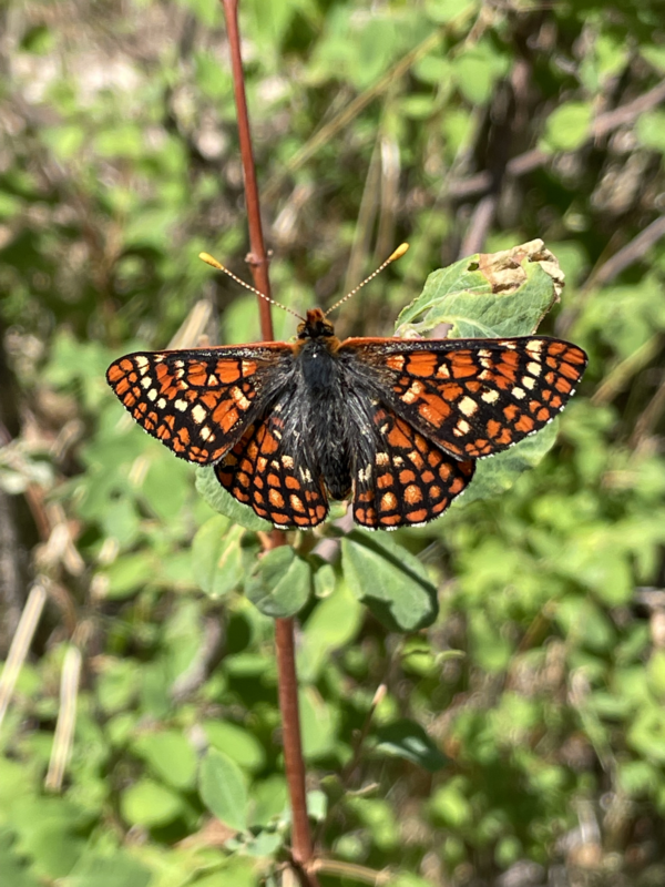
Sacramento Mountains checkerspot butterfly
The stunning orange and dark-brown butterfly is found only in high-elevation meadows in the Lincoln National Forest in southern New Mexico.
The stunning orange and dark-brown butterfly is found only in high-elevation meadows in the Lincoln National Forest in southern New Mexico.
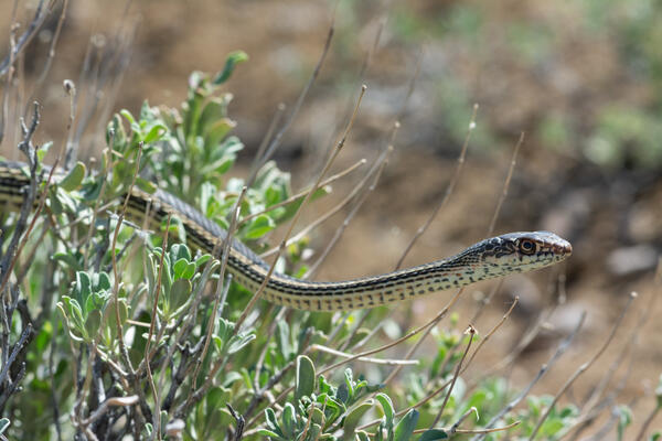
Desert striped whipsnake
A slender Desert Striped Whipsnake - coluber taeniatus.
A slender Desert Striped Whipsnake - coluber taeniatus.
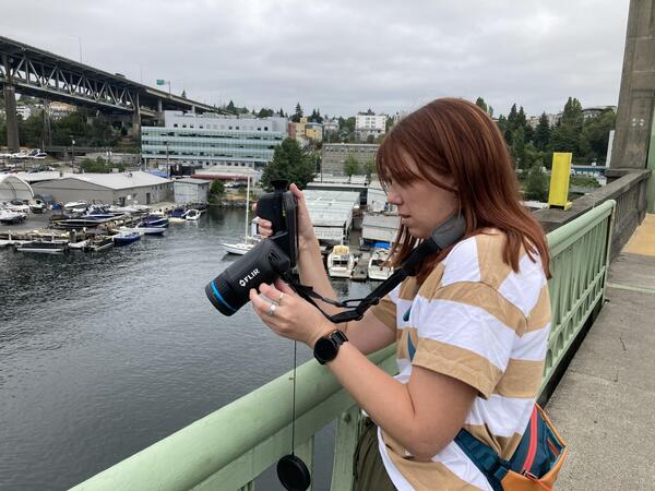
Testing a thermal infrared camera by capturing water surface temperature off the side of a bridge in Seattle, Washington
Testing a thermal infrared camera by capturing water surface temperature off the side of a bridge in Seattle, WashingtonPhoto of EAE testing and adjusting the forward-looking infrared (FLIR) camera parameters while directing the sensor at the water surface off the side of a bridge in Seattle, Washington.
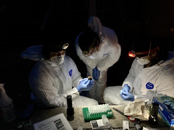
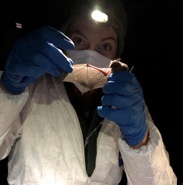
Setting up to collect samples from a bat
Scientists get ready to collect samples from a bat to test for Pseudogymnoascus destructans, the fungus that causes white-nose syndrome.
Scientists get ready to collect samples from a bat to test for Pseudogymnoascus destructans, the fungus that causes white-nose syndrome.
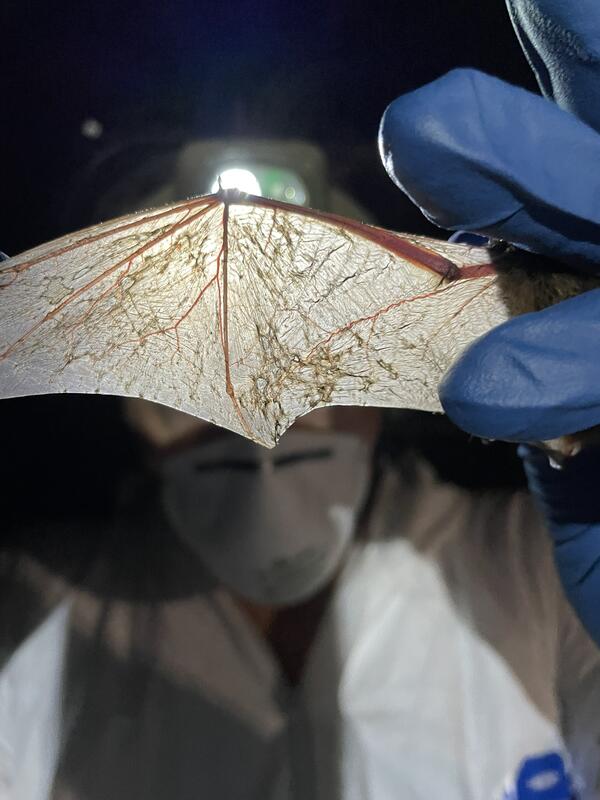
Looking for wing damage
Scientists look for damage on the skin of a bat's wing as an indicator of white-nose syndrome infection. This bat has no wing damage.
Scientists look for damage on the skin of a bat's wing as an indicator of white-nose syndrome infection. This bat has no wing damage.
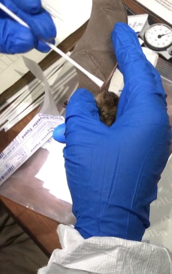
Collecting fungal samples to test for Pseudogymnoascus destructans
Collecting fungal samples to test for Pseudogymnoascus destructansIndividual bats are tested for Pseudogymnoascus destructans, the fungus that causes white-nose syndrome, by wiping a sterile swab across the skin of a bat's outstretched wing and muzzle.
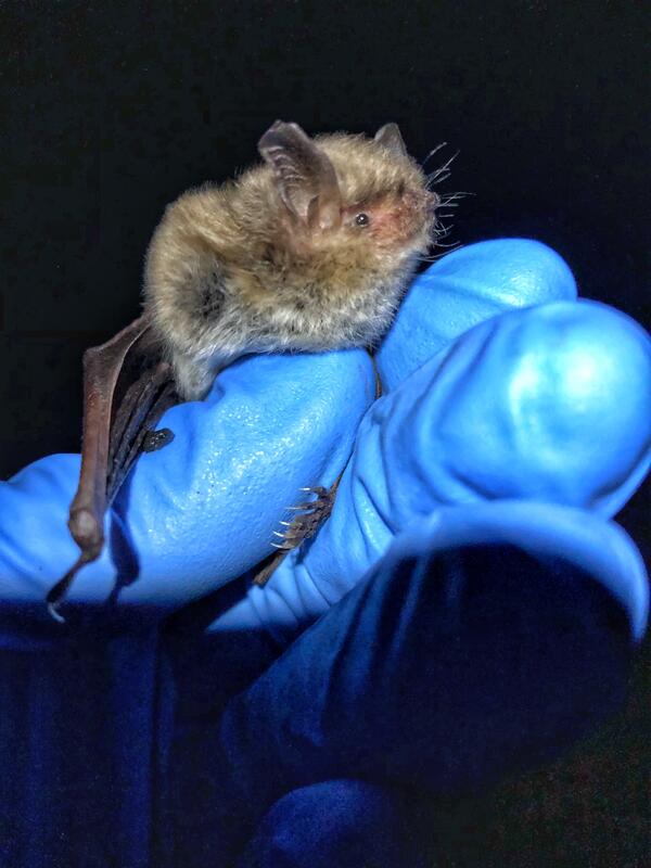
Perched Yuma myotis
Yuma myotis has a wide range throughout western North America, from the Southwestern regions of Canada into Mexico.
Yuma myotis has a wide range throughout western North America, from the Southwestern regions of Canada into Mexico.
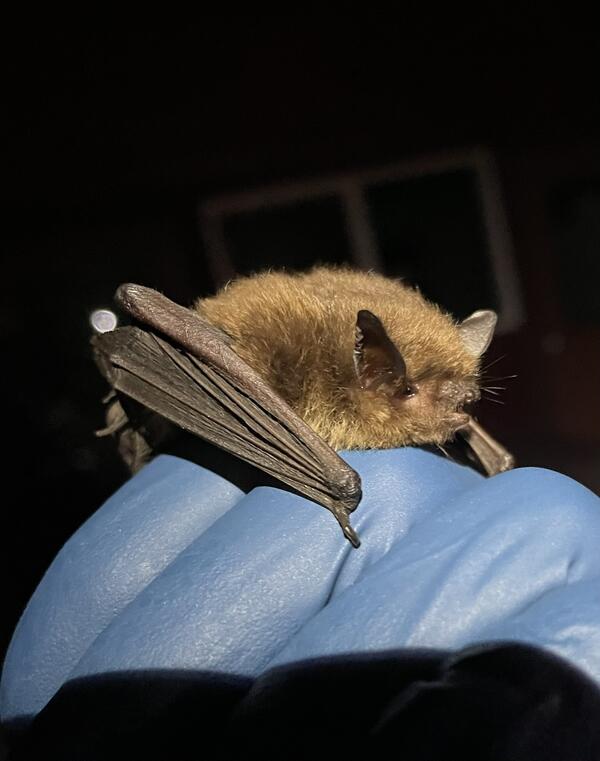
Yuma myotis bat
The Yuma myotis bat, Myotis yumanensis, has a body length of only 1.5-1.9 inches and they weigh less than half an ounce.
The Yuma myotis bat, Myotis yumanensis, has a body length of only 1.5-1.9 inches and they weigh less than half an ounce.
A bat's wing scarred by white-nose syndrome
Scars on the skin of this bat's wing suggest white-nose syndrome infection over the previous winter.
Scars on the skin of this bat's wing suggest white-nose syndrome infection over the previous winter.

15 year old female turtle
Northwestern pond turtles are sexually dimorphic (females and males look different). One way to tell female and male turtles apart is that they often have different color patterns on their face and throats. Females have a more speckled throat, while males throats tend to be more solidly white/yellow.
Northwestern pond turtles are sexually dimorphic (females and males look different). One way to tell female and male turtles apart is that they often have different color patterns on their face and throats. Females have a more speckled throat, while males throats tend to be more solidly white/yellow.

8 year old juvenile northwestern pond turtle
These turtles are considered juveniles until they reach about 5 inches long. In this part of their range turtles remain juveniles and usually do not begin to reproduce until they are over ten years old.
Photo taken at Lookout Point Reservoir, Oregon.
These turtles are considered juveniles until they reach about 5 inches long. In this part of their range turtles remain juveniles and usually do not begin to reproduce until they are over ten years old.
Photo taken at Lookout Point Reservoir, Oregon.

Juvenile Northwestern pond turtle
This is a juvenile turtle. When they aren't in scared or in danger, northwestern turtles are very curious and will look towards movements and unusual sounds to figure out what is going on. They have excellent vision and hearing.
Photo taken at Hills Creek Reservoir, Oregon.
This is a juvenile turtle. When they aren't in scared or in danger, northwestern turtles are very curious and will look towards movements and unusual sounds to figure out what is going on. They have excellent vision and hearing.
Photo taken at Hills Creek Reservoir, Oregon.

Turtle being released after receiving a new transmitter
Turtle being released after receiving a new transmitterWe glue transmitters onto their upper shells (called their carapace) using non-permanent epoxy. We will track these turtles until the transmitter battery dies (about 2 years) and soon after that the epoxy degrades, and the transmitter will fall off the turtle without harming the turtle or it's shell.

Turtle coming out of brumation
Turtle found in the spring coming out of brumation. It is still covered in mud from being buried in the ground all winter. They can brumate up to several months!
Photo taken at Lookout Point Reservoir, Oregon.
Turtle found in the spring coming out of brumation. It is still covered in mud from being buried in the ground all winter. They can brumate up to several months!
Photo taken at Lookout Point Reservoir, Oregon.

Return to overwintering spot
Northwestern pond turtles often return to the same area each winter for brumation. We tracked this turtle overwintering in almost the exact same area in the winters of 2023 and 2024. It's brumation location was only 11m apart between the two years.
Photo taken at Fall Creek Reservoir, Oregon.
Northwestern pond turtles often return to the same area each winter for brumation. We tracked this turtle overwintering in almost the exact same area in the winters of 2023 and 2024. It's brumation location was only 11m apart between the two years.
Photo taken at Fall Creek Reservoir, Oregon.

Ecologist collecting information on turtle overwintering spot
Ecologist collecting information on turtle overwintering spotThis turtle crossed a road leaving the reservoir and will cross it again to return to the reservoir. Road crossings present high risk to turtles and are a large source of mortality.
Photo taken at Lookout Point Reservoir, Oregon

RCMAP and RAP differences in performance
Rangeland Analysis Platform (RAP) and Rangeland Condition Monitoring Assessment and Projection (RCMAP) r2 values when compared to field observations. The variation between models and version was high.
Rangeland Analysis Platform (RAP) and Rangeland Condition Monitoring Assessment and Projection (RCMAP) r2 values when compared to field observations. The variation between models and version was high.

Cinnamon teal wearing a tracking backpack
Cinnamon teal with a GPS tracking backpack that weighs 10 grams, making it much more successful in staying on longer than heavier tracking devices.
Cinnamon teal with a GPS tracking backpack that weighs 10 grams, making it much more successful in staying on longer than heavier tracking devices.

Baby rough-skinned newt in a defensive posture
A young rough-skinned newt in a defensive posture known as "unkenreflex." Several amphibian species curl up their bodies to display their brightly colored bellies as a warning to predators that they are poisonous.
A young rough-skinned newt in a defensive posture known as "unkenreflex." Several amphibian species curl up their bodies to display their brightly colored bellies as a warning to predators that they are poisonous.
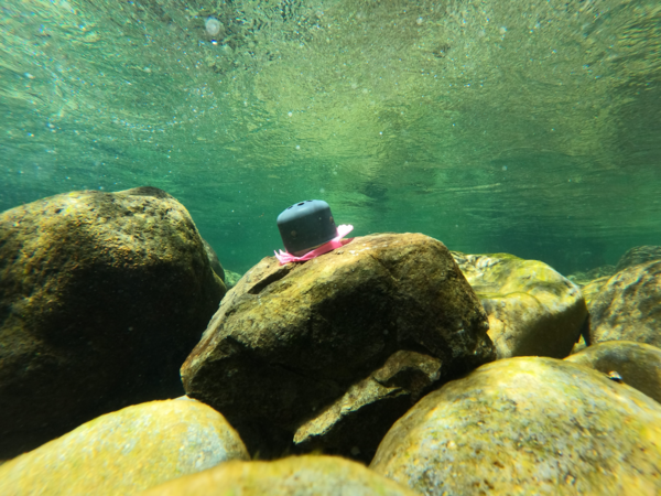
Temperature logger in Santiam River basin, Oregon
Temperature logger attached to submerged cobble in Quartzville Creek, OR. This logger was placed as part of an ongoing effort to retrieve continuous temperature data from rivers and tributaries within the Willamette River basin, OR.
Temperature logger attached to submerged cobble in Quartzville Creek, OR. This logger was placed as part of an ongoing effort to retrieve continuous temperature data from rivers and tributaries within the Willamette River basin, OR.