
Data Management and Delivery
Data Management and Delivery
Filter Total Items: 27

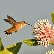
Modernized Breeding Bird Survey Portal
The North American Breeding Bird Survey (BBS) Portal is a modern information system that enables volunteer observers and regional coordinators to manage survey routes, enter field data, and coordinate route assignments online. The portal replaces legacy paper-based and outdated digital workflows with a streamlined interface built for the BBS community. Observers can view their assigned routes...
KWIC Science: Rapid response products to meet resource managers’ priority science needs
Federal public land managers in the US are required by law to use science to inform management decisions. However, managers have limited time to identify science for use in decision making. Literature reviews are one tool to efficiently summarize science for use by managers, but are time-consuming to produce. Keyword in Context (KWIC) text analysis is a straightforward method of locating specific...

Using Artificial Intelligence to Estimate Traffic to Improve Planning and Access to Colorado’s Public Lands
This project applies data-driven, machine‑learning methods to estimate average annual daily traffic on roads that connect people to Colorado’s public lands, where traffic data are sparse or nonexistent. Expanding on successful applications in Wyoming, the approach uses socioeconomic, land-use, roadway, and accessibility data to uniquely model traffic patterns from 2015 to 2025. These predictions...
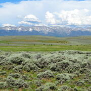
Shrubland, Alpine and Grassland Ecology (SAGE) Wildlife Research Group
The SAGE Wildlife Research Group consists of a large team of research scientists with an interest in conservation and management of wildlife and their ecosystems. Broadly, research involves understanding animal-habitat relationships, with an emphasis on conservation ecology and population demography, and a focus on shrubland, alpine, and grassland ecosystems. We are addressing the effects of...

Greater Sage-Grouse Population Monitoring Framework: Cheat Sheet
The Greater Sage-grouse Population Monitoring Framework fills a prominent information gap to help inform current assessments of sage-grouse population trends at nested spatial and temporal scales. It is centered on four objectives: (1) create a standardized database of lek counts; (2) develop biologically based spatial population structures by clustering leks; (3) estimate spatial trends at...

Greater Sage-Grouse Population Monitoring Framework: Targeted Annual Warning System Information Sheet
The Greater Sage-grouse Population Monitoring Framework helps fill a major information gap to aid current assessments of sage-grouse population trends across spatial and temporal scales. It centers on four objectives: 1) create a standardized database of lek counts; 2) cluster leks to develop spatial population structures; 3) estimate spatial trends across temporal extents; and 4) develop a system...

Greater Sage-Grouse Population Monitoring Framework: Trends Analysis Information Sheet
Land and wildlife managers require accurate estimates of sensitive species’ trends to help guide conservation decisions that maintain biodiversity and promote healthy ecosystems. Accurately assessing greater sage-grouse ( Centrocercus urophasianus; sage-grouse) population trends can be difficult because of (1) missing lek counts or incomplete repeat counts, (2) variation in counts from observer...

Data Harmonization for Greater Sage-Grouse Populations
Long-term wildlife monitoring is imperative for understanding population changes that can inform managers. However, working with population data collected by different organizations across multiple jurisdictions and over long time periods can be challenging due to varying data management approaches and organizational priorities. Through this project, we aimed to collaborate with eleven state...

Greater Sage-Grouse Population Monitoring Framework: Glossary of Terms
The Greater Sage-grouse Population Monitoring Framework helps aid current assessments of sage-grouse population trends across spatial and temporal scales. It centers on four objectives: 1) create a standardized database of lek counts; 2) cluster leks to develop spatial population structures; 3) estimate spatial trends across temporal extents; and 4) develop a system to estimate where and when...

Greater Sage-Grouse Population Monitoring Framework: Frequently Asked Questions
The Greater Sage-grouse Population Monitoring Framework helps aid current assessments of sage-grouse population trends across spatial and temporal scales. It centers on four objectives: 1) create a standardized database of lek counts; 2) cluster leks to develop spatial population structures; 3) estimate spatial trends across temporal extents; and 4) develop a system to estimate where and when...

Greater Sage-Grouse Population Monitoring Framework
Greater sage-grouse ( Centrocercus urophasianus) are at the center of state and national land use policies largely because of their unique life-history traits and their role as an ecological indicator for the health of sagebrush ecosystems. Multiple science centers with the U.S. Geological Survey (USGS) in conjunction with Colorado State University (CSU) have developed the Greater Sage-Grouse...

A user-friendly decision support tool for monitoring and managing greater sage-grouse populations
Researchers at the U.S. Geological Survey (USGS) and Colorado State University (CSU) collaborated with the Bureau of Land Management and state wildlife agencies to develop a hierarchical population monitoring framework for managing greater sage-grouse ( Centrocercus urophasianus) populations and the sagebrush ecosystems they depend on for survival and reproduction. This greater sage-grouse...