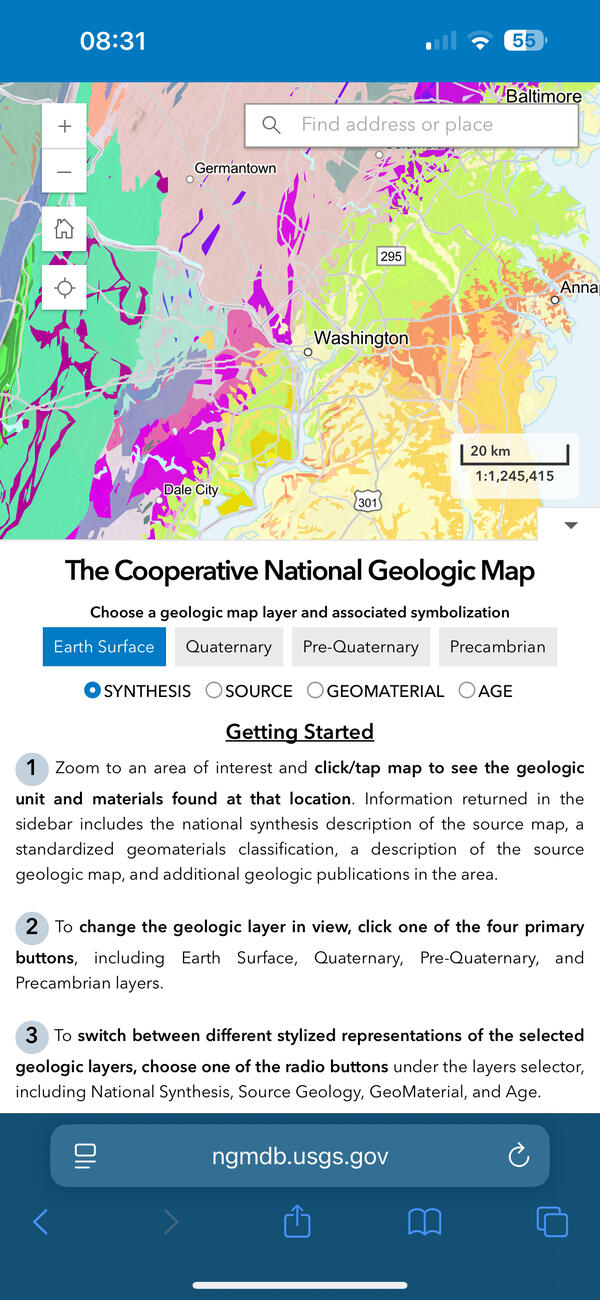
U.S. flag

An official website of the United States government

Multimedia

Images

Lance Brady (USGS NUSO) and Patricia Bright (USGS) attend meeting at the White House

On August 27th Lance Brady (USGS NUSO) attended a "White House Roundtable on Emerging Technologies for Preventing Health Emergencies" convened by the White House Office of Science & Technology Policy (OSTP). Patricia Bright, Senior Science Advisor for the USGS Ecosystems Environmental Health Program, was also in attendance.

On August 27th Lance Brady (USGS NUSO) attended a "White House Roundtable on Emerging Technologies for Preventing Health Emergencies" convened by the White House Office of Science & Technology Policy (OSTP). Patricia Bright, Senior Science Advisor for the USGS Ecosystems Environmental Health Program, was also in attendance.

National Uncrewed Systems Office - What We Do

Collage of photographs taken during various research missions performed by the National Uncrewed Systems Office (NUSO) representing What We Do

Collage of photographs taken during various research missions performed by the National Uncrewed Systems Office (NUSO) representing What We Do

National Uncrewed Systems Office - Who We Are

Collage of photographs of the researchers in the National Uncrewed Systems Office (NUSO) showing Who We Are

Top Row: 
Mark Bauer, Victoria Scholl, Joe Adams, Jill Cress, and Matt Burgess (left)
Todd Burton (middle)
Victoria Scholl (right)

Collage of photographs of the researchers in the National Uncrewed Systems Office (NUSO) showing Who We Are

Top Row: 
Mark Bauer, Victoria Scholl, Joe Adams, Jill Cress, and Matt Burgess (left)
Todd Burton (middle)
Victoria Scholl (right)

NUSO researchers prepare for evaluation flights with a vertical take-off and landing UAS

NUSO researchers Matt Burgess and Mark Bauer prepare for evaluation flights with the WingtraOne GEN II vertical take-off and landing mapping UAS equipped with the newly released lidar payload.

NUSO researchers Matt Burgess and Mark Bauer prepare for evaluation flights with the WingtraOne GEN II vertical take-off and landing mapping UAS equipped with the newly released lidar payload.

USGS personnel standing at the overlook to the quarry prior to conducting UAS operations.

USGS personnel standing at the overlook to the quarry prior to conducting UAS operations.

Thomas Casadevall (Scientist Emeritus with the Geology, Geophysics, and Geochemistry Science Center), Paco Van Sistine (GECSC), Victoria Scholl (NUSO), Matt Burgess (NUSO)

USGS personnel standing at the overlook to the quarry prior to conducting UAS operations.

Thomas Casadevall (Scientist Emeritus with the Geology, Geophysics, and Geochemistry Science Center), Paco Van Sistine (GECSC), Victoria Scholl (NUSO), Matt Burgess (NUSO)

Group photo captured using a drone standing at the overlook for the Marsh-Felch quarry.

Group photo captured using a drone. Left to right: Matt Burgess (NUSO), Paco Van Sistine (GECSC), Victoria Scholl (NUSO) standing at the overlook for the Marsh-Felch quarry.

Group photo captured using a drone. Left to right: Matt Burgess (NUSO), Paco Van Sistine (GECSC), Victoria Scholl (NUSO) standing at the overlook for the Marsh-Felch quarry.

Videos

Fixed-wing UAS used to map landscape at Corral Bluffs, Colorado The Evolution of UAS Platforms at USGS
The Evolution of UAS Platforms at USGS

The Department of the Interior (DOI) and U.S. Geological Survey (USGS) took an interest in uncrewed aircraft system (UAS) technologies in the early 2000s, when UAS were predominantly being used for military applications.

The Department of the Interior (DOI) and U.S. Geological Survey (USGS) took an interest in uncrewed aircraft system (UAS) technologies in the early 2000s, when UAS were predominantly being used for military applications.

UAS operations near Moab, Utah for carbon sequestration research on public lands UAS Operations for Carbon Sequestration Research on Public Lands near Moab, Utah in May 2023
UAS Operations for Carbon Sequestration Research on Public Lands near Moab, Utah in May 2023

In support of U.S. Geological Survey (USGS) Southwest Biological Science Center research, the USGS National Uncrewed Systems Office (NUSO) conducted uncrewed aircraft systems (UAS) remote sensing flights near Moab, Utah in May 2023 for multi-scale carbon sequestration research on public lands.  


In support of U.S. Geological Survey (USGS) Southwest Biological Science Center research, the USGS National Uncrewed Systems Office (NUSO) conducted uncrewed aircraft systems (UAS) remote sensing flights near Moab, Utah in May 2023 for multi-scale carbon sequestration research on public lands.  


Image of the Perry Victory and International Peace Memorial taken from a drone Perry Victory and International Peace Memorial Taken by Drone
Perry Victory and International Peace Memorial Taken by Drone

The NUSO and the National Park Service (NPS) Heritage Document Programs partnered in May 2024 to perform a UAS-based 3D scan of Perry’s Victory and International Peace Memorial. 

The NUSO and the National Park Service (NPS) Heritage Document Programs partnered in May 2024 to perform a UAS-based 3D scan of Perry’s Victory and International Peace Memorial. 

Field crew sit on boardwalk while collecting UAS methane measurements in Alaska 2023 USGS using drones to measure methane escaping Arctic permafrost - Aug 2023
USGS using drones to measure methane escaping Arctic permafrost - Aug 2023

As permafrost soils in the Arctic warm and thaw, greenhouse gases including methane are released into the atmosphere. USGS Ecologist Kristen Manies of the USGS Geology, Minerals, Energy, and Geophysics Science Center (GMEGSC) is researching low-cost ways to measure methane emissions across these changing ecosystems.

As permafrost soils in the Arctic warm and thaw, greenhouse gases including methane are released into the atmosphere. USGS Ecologist Kristen Manies of the USGS Geology, Minerals, Energy, and Geophysics Science Center (GMEGSC) is researching low-cost ways to measure methane emissions across these changing ecosystems.

Drone image captured during almond field mapping in the Central Valley of California Drone-based hyperspectral mapping of agricultural crop fields in California's Central Valley
Drone-based hyperspectral mapping of agricultural crop fields in California's Central Valley

In August 2023, the USGS National Uncrewed Systems Office (NUSO) participated in a collaborative field campaign to collect remote sensing data over agricultural crop fields in California's Central Valley.

Drone's eye view of a USGS remote pilot during a biocrust mission near Moab, UT Mapping biocrust with UAS technology in Moab, Utah
Mapping biocrust with UAS technology in Moab, Utah

USGS researchers teamed up for a biological soil crust (biocrust) remote sensing and field data campaign near Moab, Utah in February of 2022.

USGS researchers teamed up for a biological soil crust (biocrust) remote sensing and field data campaign near Moab, Utah in February of 2022.

Was this page helpful?