
Debris flow deposits caused by intense rainfall in April 2020 block a highway in Macon County, NC.
Images
Geologic Hazards Science Center images.
Filter Total Items: 273

Debris flow road damage - Macon County, NC
Debris flow deposits caused by intense rainfall in April 2020 block a highway in Macon County, NC.

Rainfall-triggered debris flow - Macon County, NC
Debris flow caused by intense rainfall in April 2020 in Macon County, NC.
Debris flow caused by intense rainfall in April 2020 in Macon County, NC.

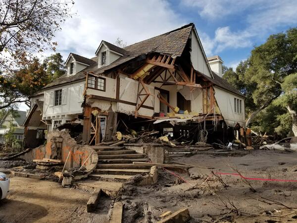
Home damaged by post-wildfire debris flow in Montecito, CA.
Home damaged by post-wildfire debris flow in Montecito, CA.Damage from a major post-wildfire landslide that occurred on 9 January 2018 near Montecito, Santa Barbara County as a result of the 2017 Thomas Fire.
Home damaged by post-wildfire debris flow in Montecito, CA.
Home damaged by post-wildfire debris flow in Montecito, CA.Damage from a major post-wildfire landslide that occurred on 9 January 2018 near Montecito, Santa Barbara County as a result of the 2017 Thomas Fire.

Debris flow after the 2003 Old Gran Prix fire
Damage from a major post-wildfire landslide that occurred on 25 December 2003 near Devore, San Bernardino County as a result of the Old/Grand Prix fires that ran through the San Bernardino Mountains.
Damage from a major post-wildfire landslide that occurred on 25 December 2003 near Devore, San Bernardino County as a result of the Old/Grand Prix fires that ran through the San Bernardino Mountains.

Alex stands in front of two flavors of Borah Peak
Alex Hatem stands in front of 1983 Borah Peak rupture with actual Borah Peak in the background.
Alex Hatem stands in front of 1983 Borah Peak rupture with actual Borah Peak in the background.

2019 Ridgecrest Earthquake Sequence: July 4, 2019–July 16, 2019
2019 Ridgecrest Earthquake Sequence: July 4, 2019–July 16, 20193,557 earthquakes recorded since July 4, 2019 above Magnitude 2
M6.4 12km W of Searles Valley, CA
2019-07-04 17:33:49 (UTC)
51,000+ responses via Did You Feel It?
M7.1 18km W of Searles Valley, CA
2019-07-06 03:19:53 (UTC)
42,000+ responses via Did You Feel It?

2019 Ridgecrest Earthquake Sequence - M7.1 Highway 178
2019 Ridgecrest Earthquake Sequence - M7.1 Highway 178Highway 178 SW of Trona. Taken earlier in the morning July 6, 2019 after the M7.1 earthquake which struck eastern California, southwest of Searles Valley, near Ridgecrest, CA.
2019 Ridgecrest Earthquake Sequence - M7.1 Highway 178
2019 Ridgecrest Earthquake Sequence - M7.1 Highway 178Highway 178 SW of Trona. Taken earlier in the morning July 6, 2019 after the M7.1 earthquake which struck eastern California, southwest of Searles Valley, near Ridgecrest, CA.

Rainfall-triggered debris flow - Powell County, Kentucky
Rainfall-triggered debris flow - Powell County, KentuckyLandslide caused by intense rainfall in June 2019 in Powell County, KY. The landslide completely destroyed the first floor and all that remains in is the second floor of the home, displayed in this image.

Rainfall and Landslides in Northern CA
A debris flow in Marin County triggered by intense rainfall destroyed several homes and injured one person during February 2019. View is looking from the top of the landslide downslope.
A debris flow in Marin County triggered by intense rainfall destroyed several homes and injured one person during February 2019. View is looking from the top of the landslide downslope.

Debris flow road damage - Polk County, NC
Heavy rainfall reactivated the 9 acre Howard Gap Landslide in February 2019, severely damaging a highway in Polk County, NC. This image only shows a small portion of a much larger landslide.
Heavy rainfall reactivated the 9 acre Howard Gap Landslide in February 2019, severely damaging a highway in Polk County, NC. This image only shows a small portion of a much larger landslide.

Damage to interior of home following Hurricane Maria - Utuado, Puerto Rico
Damage to interior of home following Hurricane Maria - Utuado, Puerto RicoA landslide caused by intense rainfall from Hurricane Maria in September 2017 in Puerto Rico hit this home, killing three people.
Damage to interior of home following Hurricane Maria - Utuado, Puerto Rico
Damage to interior of home following Hurricane Maria - Utuado, Puerto RicoA landslide caused by intense rainfall from Hurricane Maria in September 2017 in Puerto Rico hit this home, killing three people.

Large crack on hillslope formed in residential yard
Large crack on hillslope formed in residential yardCracks in a hillslope caused by slow landslide movement in Rockcastle County, Kentucky.
Large crack on hillslope formed in residential yard
Large crack on hillslope formed in residential yardCracks in a hillslope caused by slow landslide movement in Rockcastle County, Kentucky.
Montecito home damaged by post-wildfire debrisflow.
Montecito home damaged by post-wildfire debrisflow.Damage from a major post-wildfire landslide that occurred on 9 January 2018 near Montecito, Santa Barbara County as a result of the 2017 Thomas Fire.
Montecito home damaged by post-wildfire debrisflow.
Montecito home damaged by post-wildfire debrisflow.Damage from a major post-wildfire landslide that occurred on 9 January 2018 near Montecito, Santa Barbara County as a result of the 2017 Thomas Fire.

LS Preliminary Puerto Rico
Excerpt of satellite image showing landslide impacts to roads, agriculture, and a reservoir in the Lares Municipality. Points identify the approximate location of roads visibly impacted by landslides. Image filename contains approximate latitude and longitude of this impact location.
Excerpt of satellite image showing landslide impacts to roads, agriculture, and a reservoir in the Lares Municipality. Points identify the approximate location of roads visibly impacted by landslides. Image filename contains approximate latitude and longitude of this impact location.

Slow landslide building damage - Boyd County, Kentucky
Slow landslide building damage - Boyd County, KentuckyBuilding damage caused by a slow landslide in Boyd County, Kentucky, 2017
Slow landslide building damage - Boyd County, Kentucky
Slow landslide building damage - Boyd County, KentuckyBuilding damage caused by a slow landslide in Boyd County, Kentucky, 2017

Hurricane Maria debris flows - Naranjito, Puerto Rico 2017
Hurricane Maria debris flows - Naranjito, Puerto Rico 2017Numerous debris flows caused by intense rainfall from Hurricane Maria in September 2017 in Puerto Rico. Trees are bare due to the hurricane force winds that stripped the leaves.
Hurricane Maria debris flows - Naranjito, Puerto Rico 2017
Hurricane Maria debris flows - Naranjito, Puerto Rico 2017Numerous debris flows caused by intense rainfall from Hurricane Maria in September 2017 in Puerto Rico. Trees are bare due to the hurricane force winds that stripped the leaves.

Rainfall and Landslides in Northern CA
Shallow landslides damaged homes and closed many roads in the San Francisco East Bay region as a result of storms in January and February, 2017.
Shallow landslides damaged homes and closed many roads in the San Francisco East Bay region as a result of storms in January and February, 2017.

Home damaged by rainfall-triggered debris flow - King County, Washington
Home damaged by rainfall-triggered debris flow - King County, WashingtonLandslide caused by intense rainfall in February 2017 in King County, WA. The rapid landslide destroyed a garage and a large propane tank.
Home damaged by rainfall-triggered debris flow - King County, Washington
Home damaged by rainfall-triggered debris flow - King County, WashingtonLandslide caused by intense rainfall in February 2017 in King County, WA. The rapid landslide destroyed a garage and a large propane tank.

Salt Creek Rock Avalanche in Western Colorado
Photograph taken from a Colorado National Guard helicopter looking north down the West Salt Creek rock avalanche deposit. On May 25, 2014, the central core of the rock avalanche deposit continued to move for 1-2 hours after the main rock avalanche deposit had stopped moving.
Photograph taken from a Colorado National Guard helicopter looking north down the West Salt Creek rock avalanche deposit. On May 25, 2014, the central core of the rock avalanche deposit continued to move for 1-2 hours after the main rock avalanche deposit had stopped moving.

Slow landslide building damage - Boyd County, Kentucky
Slow landslide building damage - Boyd County, KentuckyBuilding damage caused by a slow landslide in Boyd County, Kentucky. Previous repairs reveal that the landslide has moved in the past.
Slow landslide building damage - Boyd County, Kentucky
Slow landslide building damage - Boyd County, KentuckyBuilding damage caused by a slow landslide in Boyd County, Kentucky. Previous repairs reveal that the landslide has moved in the past.

Geomagnetism Fredericksburg
More signs for Fredericksburg Magnetic Observatory.
More signs for Fredericksburg Magnetic Observatory.