
A determined USGS research crew sets out on Lake Huron by small vessel to lift micromesh gillnets in search of elusive juvenile lake whitefish. Photo credit: Cory Brant, USGS.
Images
Images captured by GLSC scientists while working in and around the Great Lakes.
Filter Total Items: 494

The Search for Juvenile Lake Whitefish
A determined USGS research crew sets out on Lake Huron by small vessel to lift micromesh gillnets in search of elusive juvenile lake whitefish. Photo credit: Cory Brant, USGS.

An Ancient Visitor
A flathead catfish (Pylodictis olivaris) captured along an electrofishing transect at the Shiawassee National Wildlife Refuge near Saginaw, Michigan. Photo credit: Sasha Bozimowski, USGS.
A flathead catfish (Pylodictis olivaris) captured along an electrofishing transect at the Shiawassee National Wildlife Refuge near Saginaw, Michigan. Photo credit: Sasha Bozimowski, USGS.

Lab-Reared, Young of Year Sea Lamprey
This invasive sea lamprey (Petromyzon marinus) was spawned in the laboratory using artificial fertilization methods. It is 6 weeks post-fertilization and feeding externally. Photo credit: Trisha Searcy, USGS.
This invasive sea lamprey (Petromyzon marinus) was spawned in the laboratory using artificial fertilization methods. It is 6 weeks post-fertilization and feeding externally. Photo credit: Trisha Searcy, USGS.

USGS Director David Applegate Delivers Remarks During the Celebration of USGS Advanced Technologies in Fisheries
USGS Director David Applegate Delivers Remarks During the Celebration of USGS Advanced Technologies in FisheriesUSGS Director David Applegate delivers remarks during the celebration of USGS advanced technologies in fisheries science on the Great Lakes, August 9, 2022, in Ashland, Wisconsin. Photo credit: Andrea Miehls, USGS.

Vessels Large and Small
A Saildrone uncrewed surface vehicle and the USGS research vessel Kiyi at the Ashland, Wisconsin, launch event in early August to kick off the month-long mission in western Lake Superior. Photo credit: Andrea Miehls, USGS
A Saildrone uncrewed surface vehicle and the USGS research vessel Kiyi at the Ashland, Wisconsin, launch event in early August to kick off the month-long mission in western Lake Superior. Photo credit: Andrea Miehls, USGS

Representative Tom Tiffany and USGS Director David Applegate are Joined by Saildrone and GLSC Officials in Front of a Saildrone Explorer
Representative Tom Tiffany and USGS Director David Applegate are Joined by Saildrone and GLSC Officials in Front of a Saildrone ExplorerUSGS Director Applegate (center) gathers near a remotely-helmed Saildrone Explorer with U.S. Congressman Tom Tiffany (WI) (second from left), USGS Great Lakes Science Center Director Russell Strach (second from right), Saildrone Director of Ocean Data Programs Matt Womble (right), and USGS Biologist Josh Miller (left) on August 9, 2022, in Ashland, Wisconsin.

DOI and USGS Officials Learn About Hydroacoustics Technology Aboard the USGS Research Vessel Kiyi
DOI and USGS Officials Learn About Hydroacoustics Technology Aboard the USGS Research Vessel KiyiDOI Assistant Secretary for Water and Science Tanya Trujillo and USGS Director David Applegate learn about hydroacoustics technology aboard the USGS research vessel Kiyi from USGS scientist Dan Yule and fishery management partners, August 9, 2022.

Leaders, Managers, and Researchers with the Research Vessel Kiyi
Leaders, Managers, and Researchers with the Research Vessel KiyiDOI and USGS leadership, scientists, and staff are joined by Great Lakes fishery science and management partners for an evening cruise aboard the 107’ USGS research vessel Kiyi in Lake Superior off Ashland, Wisconsin, on August 8, 2022.
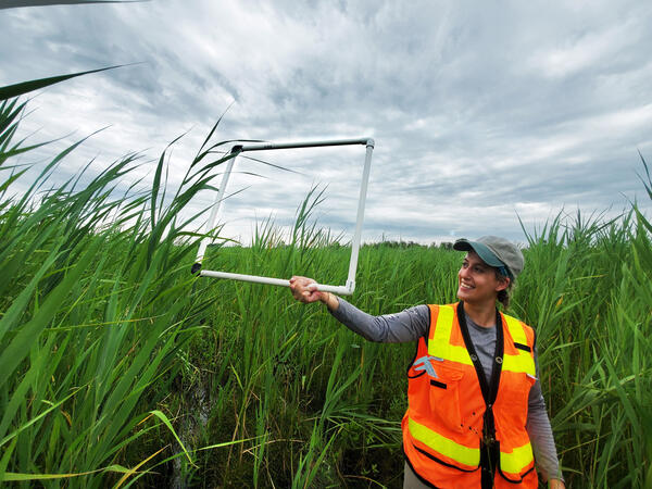
Estimating Phragmites Density
Staff member from the Great Lakes Commission performing annual monitoring for the Phragmites Adaptive Management Framework (PAMF). Photo Credit: Taaja Tucker-Silva, USGS.
Staff member from the Great Lakes Commission performing annual monitoring for the Phragmites Adaptive Management Framework (PAMF). Photo Credit: Taaja Tucker-Silva, USGS.

USGS Biologist Captures a Bumble Bee
USGS biologist Stacy Simanonok captures a bumble bee in a net during a pollinator survey in the grasslands of the North Dakota plains. Researchers are testing environmental DNA sampling methods to determine if this less invasive way to survey for pollinators generates similar results as traditional netting methods.
USGS biologist Stacy Simanonok captures a bumble bee in a net during a pollinator survey in the grasslands of the North Dakota plains. Researchers are testing environmental DNA sampling methods to determine if this less invasive way to survey for pollinators generates similar results as traditional netting methods.
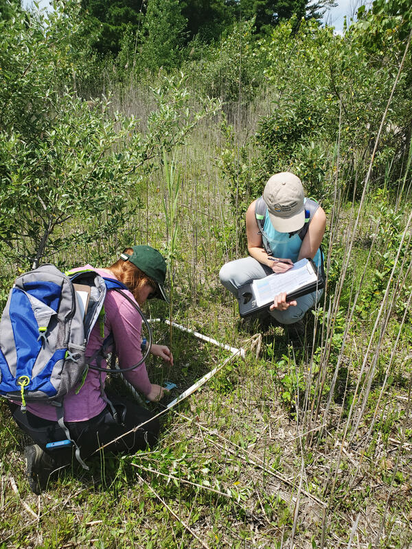
Monitoring Phragmites australis
Monitoring invasive Phragmites australis as part of the Phragmites Adaptive Management Framework. Credit: Theresa Gruninger, USGS.
Monitoring invasive Phragmites australis as part of the Phragmites Adaptive Management Framework. Credit: Theresa Gruninger, USGS.
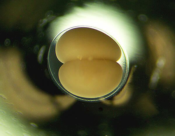
Sea lamprey Embryo
An invasive sea lamprey egg fertilized in the lab at the USGS Hammond Bay Biological Station on August 1, 2022, and photographed at stage 2 of its development. Photo credit: Trisha Searcy, USGS.
An invasive sea lamprey egg fertilized in the lab at the USGS Hammond Bay Biological Station on August 1, 2022, and photographed at stage 2 of its development. Photo credit: Trisha Searcy, USGS.

Breaking the Surface
Lotus pads (Nelumbo lutea) and cattails (Typha sp.) emerging in the Metzger Marsh Wildlife Area adjacent to Lake Erie. Photo credit: Kaira Liggett, USGS (contractor).
Lotus pads (Nelumbo lutea) and cattails (Typha sp.) emerging in the Metzger Marsh Wildlife Area adjacent to Lake Erie. Photo credit: Kaira Liggett, USGS (contractor).

Kiyi in Grand Marais
USGS Great Lakes Science Center’s research vessel Kiyi moored at a breakwater in Lake Superior at Grand Marais, Minnesota. Photo credit: Joe Walters, USGS.
USGS Great Lakes Science Center’s research vessel Kiyi moored at a breakwater in Lake Superior at Grand Marais, Minnesota. Photo credit: Joe Walters, USGS.

Cutting Down an Invasive Species
USGS Biologist Wes Bickford cutting invasive Phragmites australis underwater. Credit: Spencer Widin, USGS
USGS Biologist Wes Bickford cutting invasive Phragmites australis underwater. Credit: Spencer Widin, USGS

Phragmites, Cut-to-Drown
GLSC’s Kaira Liggett next to a floating mass of cut Phragmites at Metzger Marsh in Oak Harbor, OH. Photo credit: Wes Bickford, USGS.
GLSC’s Kaira Liggett next to a floating mass of cut Phragmites at Metzger Marsh in Oak Harbor, OH. Photo credit: Wes Bickford, USGS.

Chicago Sunset
A sunset on Lake Michigan with the Chicago skyline in the distance as seen from Ogden Dunes Beach within Indiana Dunes National Park, Indiana. Photo credit: Johanna Nifosi, USGS.
A sunset on Lake Michigan with the Chicago skyline in the distance as seen from Ogden Dunes Beach within Indiana Dunes National Park, Indiana. Photo credit: Johanna Nifosi, USGS.

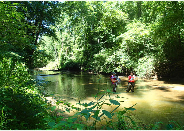
Partners in Wetlands
Researchers from multiple federal and academic institutions work together to capture, measure, and count fish in a restored coastal wetland habitat using an electrofishing catamaran at the Shiawassee National Wildlife Refuge, near Saginaw, Michigan. Photo credit: Meagan Froeba, USGS.
Researchers from multiple federal and academic institutions work together to capture, measure, and count fish in a restored coastal wetland habitat using an electrofishing catamaran at the Shiawassee National Wildlife Refuge, near Saginaw, Michigan. Photo credit: Meagan Froeba, USGS.
Stream Sampling
USGS technicians sample for fatmucket (Lampsilis siliquoidea) environmental-DNA in the Little Calumet River for a native mussel restoration project at Indiana Dunes National Park, Indiana. Photo credit: Ashley Spoljaric, USGS (contractor).
USGS technicians sample for fatmucket (Lampsilis siliquoidea) environmental-DNA in the Little Calumet River for a native mussel restoration project at Indiana Dunes National Park, Indiana. Photo credit: Ashley Spoljaric, USGS (contractor).
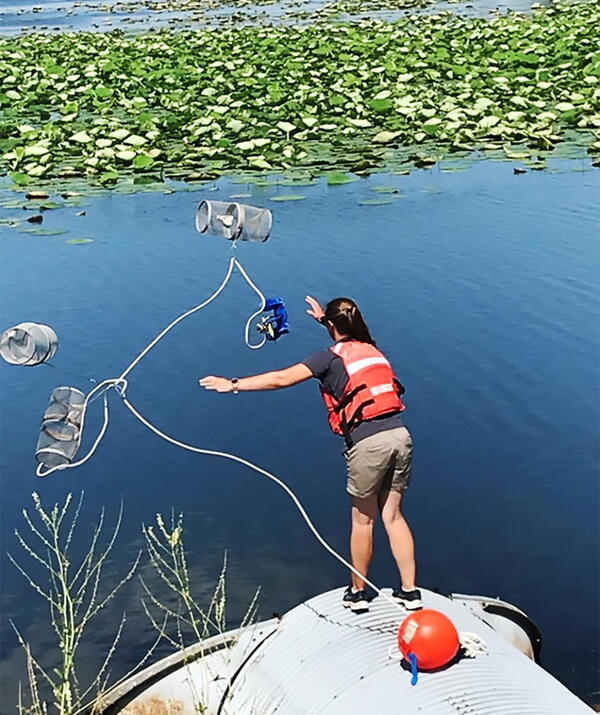
Deploying Minnow Traps in Western Lake Erie
Great Lakes Science Center fisheries technician Stacey Ireland deploying minnow traps in western Lake Erie to collect fishes for the parasite research team. Photo credit Ed Roseman USGS GLSC.
Great Lakes Science Center fisheries technician Stacey Ireland deploying minnow traps in western Lake Erie to collect fishes for the parasite research team. Photo credit Ed Roseman USGS GLSC.

Not Grounded
A lagoon covered with a floating mat of aquatic plants at West Beach, Indiana Dunes National Park, Indiana. Photo credit: Johanna Nifosi, USGS.
A lagoon covered with a floating mat of aquatic plants at West Beach, Indiana Dunes National Park, Indiana. Photo credit: Johanna Nifosi, USGS.