
A pair of shaggy ink cap mushrooms on a gravel path near the Big Tub Lighthouse in Tobermory, Ontario. Photo credit: Kristy Phillips, USGS.
Images
Images captured by GLSC scientists while working in and around the Great Lakes.
Filter Total Items: 494
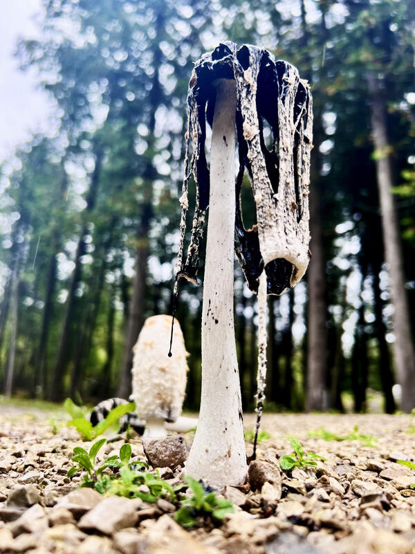
Shaggy Ink Cap
A pair of shaggy ink cap mushrooms on a gravel path near the Big Tub Lighthouse in Tobermory, Ontario. Photo credit: Kristy Phillips, USGS.

Lake Erie Bottom Trawling
USGS Great Lakes Science Center technician processes a bottom trawl catch aboard the research vessel Muskie on Lake Erie during rough seas. Photo credit: Mark DuFour, USGS.
USGS Great Lakes Science Center technician processes a bottom trawl catch aboard the research vessel Muskie on Lake Erie during rough seas. Photo credit: Mark DuFour, USGS.

Les Cheneaux Pano
An open embayment coastal wetland sits timeless within the Les Cheneaux Islands on the northern shore of Lake Huron, Michigan. Photo credit: Sasha Bozimowski, USGS.
An open embayment coastal wetland sits timeless within the Les Cheneaux Islands on the northern shore of Lake Huron, Michigan. Photo credit: Sasha Bozimowski, USGS.
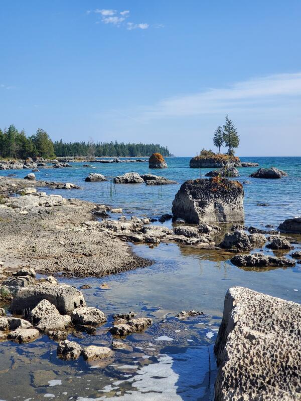
Narnia Coastline
Limestone formations at the John Arthur Woollam Preserve on the northern shore of Lake Huron. Photo credit: Taaja Tucker-Silva, USGS.
Limestone formations at the John Arthur Woollam Preserve on the northern shore of Lake Huron. Photo credit: Taaja Tucker-Silva, USGS.

A Rocky Shoreline Near the Sault Ste. Marie, MI
A rocky shoreline near Sault Ste. Marie Michigan visited by participants of the 2022 Great Lakes Coastal Wetlands Symposium.
A rocky shoreline near Sault Ste. Marie Michigan visited by participants of the 2022 Great Lakes Coastal Wetlands Symposium.

A Shoreline Near Sault Ste. Marie, Michigan
A shoreline near Sault Ste. Marie, Michigan visited by participants of the 2022 Great Lakes Coastal Wetlands Symposium. Photo Credit: Wes Bickford, USGS.
A shoreline near Sault Ste. Marie, Michigan visited by participants of the 2022 Great Lakes Coastal Wetlands Symposium. Photo Credit: Wes Bickford, USGS.

Costal Fen Wetland Near Sault Ste. Marie, MI
A Coastal fen wetland near Sault Ste. Marie, MI visited by participant of the 2022 Great Lakes Coastal Symposium. Photo Credit: Wes Bickford, USGS
A Coastal fen wetland near Sault Ste. Marie, MI visited by participant of the 2022 Great Lakes Coastal Symposium. Photo Credit: Wes Bickford, USGS

A Carnivorous Butterwort Plant Near Sault Ste. Marie
A Carnivorous Butterwort Plant Near Sault Ste. MarieA carnivorous butterwort plant near Sault Ste. Marie visited during the 2022 Great Lakes Coastal Wetlands Symposium. Photo Credit: Wes Bickford, USGS.
A Carnivorous Butterwort Plant Near Sault Ste. Marie
A Carnivorous Butterwort Plant Near Sault Ste. MarieA carnivorous butterwort plant near Sault Ste. Marie visited during the 2022 Great Lakes Coastal Wetlands Symposium. Photo Credit: Wes Bickford, USGS.

Munuscong Bay Coastal Wetland Welcome Sign and Wetland
Munuscong Bay Coastal Wetland Welcome Sign and WetlandParticipants at the 2022 Great Lakes Coastal Symposium visited Munuscong Bay coastal wetland on September 20, which is located on the St. Marys River in Michigan's Upper Peninsula to learn about Manoomin replanting efforts, water-level management, and the overall ecology of this valued area. Photo Credit: Kurt Kowalski, USGS.

Pitcher Plant in a Fen Wetland Near Sault Ste. Marie
Pitcher Plant in a Fen Wetland Near Sault Ste. MarieA Pitcher Plant in a fen wetland near near Sault Ste. Marie visited by participant of the 2022 Great Lakes Coastal Symposium. Photo Credit: Wes Bickford, USGS.
Pitcher Plant in a Fen Wetland Near Sault Ste. Marie
Pitcher Plant in a Fen Wetland Near Sault Ste. MarieA Pitcher Plant in a fen wetland near near Sault Ste. Marie visited by participant of the 2022 Great Lakes Coastal Symposium. Photo Credit: Wes Bickford, USGS.

Tangled
Northern cedar roots tangled amongst the bedrock at the John Arthur Woollam Preserve that sits along the northern shore of Lake Huron. Photo credit: Sasha Bozimowski, USGS.
Northern cedar roots tangled amongst the bedrock at the John Arthur Woollam Preserve that sits along the northern shore of Lake Huron. Photo credit: Sasha Bozimowski, USGS.

Larval Diversity
The diversity of larval fishes from one 10-minute tow collected at the surface of Lake Huron by USGS scientists during the 2022 Lake Huron Cooperative Science and Monitoring Initiative survey. Photo credit: Cory Brant, USGS.
The diversity of larval fishes from one 10-minute tow collected at the surface of Lake Huron by USGS scientists during the 2022 Lake Huron Cooperative Science and Monitoring Initiative survey. Photo credit: Cory Brant, USGS.

Dr. Robin DeBruyne Delivers her Talk on “Patterns in angler-caught walleye diets from Saginaw Bay, Michigan”
Dr. Robin DeBruyne Delivers her Talk on “Patterns in angler-caught walleye diets from Saginaw Bay, Michigan”Dr. Robin DeBruyne Delivers her Talk on “Patterns in angler-caught walleye diets from Saginaw Bay, Michigan” at the International Percid Fish Symposium, in the Czech Republic.

Rust patched bumblebee visiting white flowers
The rusty patched bumblebee is the first bee to be listed as endangered in the continental US, and the western bumblebee has been the subject of extensive USGS work that has found effects of climate, land cover change, and pesticides on the decline of the species.
The rusty patched bumblebee is the first bee to be listed as endangered in the continental US, and the western bumblebee has been the subject of extensive USGS work that has found effects of climate, land cover change, and pesticides on the decline of the species.

Net on a Deck
Two USGS crewmembers guiding a fine-mesh neuston net up off the deck of the USGS research vessel Kiyi and into the water to sample for larval fish. Photo credit: Lori Evrard, USGS.
Two USGS crewmembers guiding a fine-mesh neuston net up off the deck of the USGS research vessel Kiyi and into the water to sample for larval fish. Photo credit: Lori Evrard, USGS.

Bull Elk
A bull elk (Cervus canadensis) observed in Michigan’s Pigeon River Country State Forest while checking sea lamprey nets during a sea lamprey treatment. Photo credit: Tyler Bruning, USGS.
A bull elk (Cervus canadensis) observed in Michigan’s Pigeon River Country State Forest while checking sea lamprey nets during a sea lamprey treatment. Photo credit: Tyler Bruning, USGS.

Golden Hour
Two USGS technicians lowering a conductivity, temperature, and depth sensor into Lake Superior at dusk on the back deck of the Great Lakes Science Center’s research vessel Kiyi during a nighttime survey. Photo credit: Lori Evrard, USGS.
Two USGS technicians lowering a conductivity, temperature, and depth sensor into Lake Superior at dusk on the back deck of the Great Lakes Science Center’s research vessel Kiyi during a nighttime survey. Photo credit: Lori Evrard, USGS.

Quarantine
A group of Bleeding Fairy Helmet fungi (Mycena haematopus) infected by other fungi hyphae and separated from a healthy colony, as seen in Heron Rookery, Indiana Dunes National Park, Indiana. Photo credit: Johanna Nifosi, USGS.
A group of Bleeding Fairy Helmet fungi (Mycena haematopus) infected by other fungi hyphae and separated from a healthy colony, as seen in Heron Rookery, Indiana Dunes National Park, Indiana. Photo credit: Johanna Nifosi, USGS.

Running a Polymerase Chain Reaction
Aaron Aunins (Eastern Ecological Science Center, Leetown, West Virginia) prepares samples for polymerase chain reaction (PCR) as Kasia Kelly (left) and Dawn Shively (middle) (both from Great Lakes Science Center, Chesterton, Indiana) observe and document the procedure. Photo credit: Murulee Byappanahalli, USGS.
Aaron Aunins (Eastern Ecological Science Center, Leetown, West Virginia) prepares samples for polymerase chain reaction (PCR) as Kasia Kelly (left) and Dawn Shively (middle) (both from Great Lakes Science Center, Chesterton, Indiana) observe and document the procedure. Photo credit: Murulee Byappanahalli, USGS.

Bioherbicide in Action
Characteristic impact of bioherbicide on Phragmites leaf tissue. Browning/yellowing of leaf tissues and dark spots formation indicate cellular death and microbial community bloom (i.e., mold), respectively. Photo credit: USGS
Characteristic impact of bioherbicide on Phragmites leaf tissue. Browning/yellowing of leaf tissues and dark spots formation indicate cellular death and microbial community bloom (i.e., mold), respectively. Photo credit: USGS

LRAUV Preparing for Shore Launch
The Monterey Bay Aquarium Research Institute’s Long Range Autonomous Underwater Vehicle (LRAUV) on the beach in Muskegon, Michigan, prior to being launched into Lake Michigan for a mission with USGS scientists. Photo credit: Alden Tilley, USGS.
The Monterey Bay Aquarium Research Institute’s Long Range Autonomous Underwater Vehicle (LRAUV) on the beach in Muskegon, Michigan, prior to being launched into Lake Michigan for a mission with USGS scientists. Photo credit: Alden Tilley, USGS.