
An early morning trip out on Lake Huron near Alpena, Michigan, for a USGS acoustic telemetry crew. Photo credit: Brad Buechel, USGS.
Images
Images captured by GLSC scientists while working in and around the Great Lakes.
Filter Total Items: 494

Research Vessel Ocqueoc in Misery Bay at Sunrise
An early morning trip out on Lake Huron near Alpena, Michigan, for a USGS acoustic telemetry crew. Photo credit: Brad Buechel, USGS.

I Will Pinch You
Native to the Great Lakes, this virile or northern crayfish (Faxonius virilis) was collected from a gillnet in the Northern Refuge of Lake Michigan during a fall lake trout spawner survey. Photo credit: Patty Dieter, USGS.
Native to the Great Lakes, this virile or northern crayfish (Faxonius virilis) was collected from a gillnet in the Northern Refuge of Lake Michigan during a fall lake trout spawner survey. Photo credit: Patty Dieter, USGS.

Tag Team
USGS researchers tagging recently caught lake whitefish that will be released back into Lake Huron for an acoustic telemetry project to track fish movements. Photo credit: Chris Holbrook, USGS.
USGS researchers tagging recently caught lake whitefish that will be released back into Lake Huron for an acoustic telemetry project to track fish movements. Photo credit: Chris Holbrook, USGS.

Alpena Fall Forage
Leaving Alpena for a day of Great Lakes science during the Lake Huron fall forage fish survey. Photo credit: Cory Brant, USGS.
Leaving Alpena for a day of Great Lakes science during the Lake Huron fall forage fish survey. Photo credit: Cory Brant, USGS.

Slimy Sculpin
A slimy sculpin (Cottus cognatus) surrounded by rocks in Lake Superior. Photo credit: Scott Dwyer, USGS.
A slimy sculpin (Cottus cognatus) surrounded by rocks in Lake Superior. Photo credit: Scott Dwyer, USGS.

Burbot at Night
A burbot (Lota lota) between rocks illuminated by a dive light at night, in Lake Superior. Photo credit: Alden Tilley, USGS.
A burbot (Lota lota) between rocks illuminated by a dive light at night, in Lake Superior. Photo credit: Alden Tilley, USGS.

Up Close Larval Fish Assumed to be a Coregonine Species
Up Close Larval Fish Assumed to be a Coregonine SpeciesA larval coregonine, collected by USGS scientists during the 2022 Cooperative Science and Monitoring Initiative survey on Lake Huron, is examined and identified using a stereo microscope and high-resolution camera. Photo credit: Cory Brant, USGS.

USGS Director David Applegate Learns About Fish Aging
USGS Director David Applegate Learns About Fish AgingFisheries Technician Kristy Phillips (GLSC-Ann Arbor) demonstrates fish aging using the annular rings in fish scales for USGS Director David Applegate. Photo Credit: Josh Miller (USGS).
USGS Director David Applegate Learns About Fish Aging
USGS Director David Applegate Learns About Fish AgingFisheries Technician Kristy Phillips (GLSC-Ann Arbor) demonstrates fish aging using the annular rings in fish scales for USGS Director David Applegate. Photo Credit: Josh Miller (USGS).

USGS Director David Applegate and Others Learn About Invasive Phragmites australis
USGS Director David Applegate and Others Learn About Invasive Phragmites australisUSGS Director David Applegate along with Associate Director Anne Kinsinger and Dr. Kurt Kowalski listen to Dr. Wes Bickford describe invasive Phragmites australis and the research being done at the Great Lakes Science Center to control it. Photo Credit: Josh Miller (USGS)

USGS Director David Applegate and others listen to Dr. Ed Roseman talk about lake sturgeon
USGS Director David Applegate and others listen to Dr. Ed Roseman talk about lake sturgeonUSGS Director David Applegate, along with Associate Director Anne Kinsinger and Dr. Bo Bunnell listen to Dr. Ed Roseman describe the life cycle of lake sturgeon. Photo Credit: Josh Miller (USGS).

GLSC Researchers Show USGS Director David Applegate a tank of Sea Lamprey
GLSC Researchers Show USGS Director David Applegate a tank of Sea LampreyUSGS Director David Applegate looks at Sea Lamprey in a tank at the Great Lakes Science Center. Dr. Bo Bunnell and Kevin Keeler describe the animal and our work with this invasive species. Photo Credit: Josh Miller (USGS).

Preparing Flower Sample Replicates
Preparing flower samples for spiking with known DNA for a method development experiment evaluating pollinator environmental-DNA recovery from flowers. Photo credit: Dawn Shively, USGS (contractor).
Preparing flower samples for spiking with known DNA for a method development experiment evaluating pollinator environmental-DNA recovery from flowers. Photo credit: Dawn Shively, USGS (contractor).

Pollinator Experiment Assembly Line
USGS scientists busy developing methods for identifying pollinators using environmental-DNA. Photo credit: Dawn Shively, USGS (contractor).
USGS scientists busy developing methods for identifying pollinators using environmental-DNA. Photo credit: Dawn Shively, USGS (contractor).

USGS Facilitates USFWS and GLFC Collaboration with Polish Company
USGS Facilitates USFWS and GLFC Collaboration with Polish CompanyThe tour group, from left to right, included Scott Miehls and Tyler Bruning (USGS-GLSC), Sabina Ziola (Procom), Nick Johnson (USGS-GLSC), Krzysztof Niezabitowski (Procom), and Pete Hrodey (USFWS). Photo credit: Andrea Miehls, USGS.

R/V Sturgeon from the View of a Paddle Boader
A unique perspective of the Great Lakes Science Center’s research vessel Sturgeon while docked in Kilarney, Ontario, during the 2022 hydroacoustic fishery assessment. Photo credit: Kristy Phillips, USGS.
A unique perspective of the Great Lakes Science Center’s research vessel Sturgeon while docked in Kilarney, Ontario, during the 2022 hydroacoustic fishery assessment. Photo credit: Kristy Phillips, USGS.

Smoke on the Water, Fire in the Sky
Approaching the Port Washington Breakwater Light in Wisconsin on a foggy Lake Michigan while heading out for a day of trawling aboard the USGS research vessel Arcticus during a fall forage fish survey. Photo credit: Patty Dieter, USGS.
Approaching the Port Washington Breakwater Light in Wisconsin on a foggy Lake Michigan while heading out for a day of trawling aboard the USGS research vessel Arcticus during a fall forage fish survey. Photo credit: Patty Dieter, USGS.
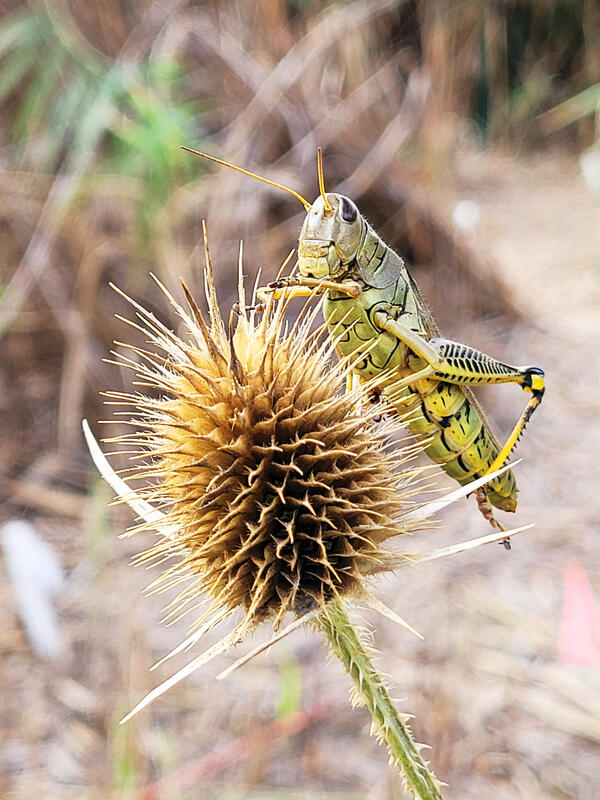
King of Comfort
Grasshopper resting on common teasel (Dipsacus fullonum). Photo credit: Taaja Tucker-Silva, USGS.
Grasshopper resting on common teasel (Dipsacus fullonum). Photo credit: Taaja Tucker-Silva, USGS.

Control Site for Phragmites australis Bioherbicide
Control Site for Phragmites australis BioherbicideThis image taken on 28 September 2022 depicts a control patch of Phragmites australis after treatment with water. Photo Credit: Spencer Widin
Control Site for Phragmites australis Bioherbicide
Control Site for Phragmites australis BioherbicideThis image taken on 28 September 2022 depicts a control patch of Phragmites australis after treatment with water. Photo Credit: Spencer Widin
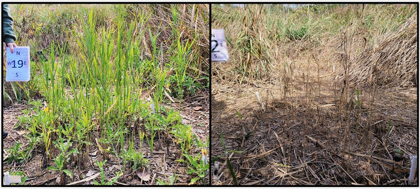
Phragmites Before and After Application of a Bioherbicide
Phragmites Before and After Application of a BioherbicideCharacteristic visual differences between control plots receiving water treatment (left) and experimental plots receiving bioherbicide treatment (right). Photo Credit: Spencer Widin, USGS.

Test Site for Phragmites australis Bioherbicide
This image taken on 28 September 2022 depicts a test patch of Phragmites australis after treatment with a bioherbicide. Photo Credit: Spencer Widin
This image taken on 28 September 2022 depicts a test patch of Phragmites australis after treatment with a bioherbicide. Photo Credit: Spencer Widin

Tobermory
View of the north side of the Big Tub lighthouse looking out on Lake Huron in Tobermory, Ontario, at the tip of the Bruce Peninsula in Lake Huron. Photo credit: Kristy Phillips, USGS.
View of the north side of the Big Tub lighthouse looking out on Lake Huron in Tobermory, Ontario, at the tip of the Bruce Peninsula in Lake Huron. Photo credit: Kristy Phillips, USGS.