
East Fork Carson River near Markleeville
West Fork Carson River at Woodfords
Carson River near Genoa
Carson River at Deer Run Rd
Carson River near Fort Churchill
The Carson River is an important water resource for residents, agriculture, and wildlife. The USGS provides science support on water quality and quantity, as well as on the impacts of climate change on water resources in the basin.

Geography
The Carson River Basin (State of Nevada hydrographic region 8) is nearly 4,000 square miles and stretches about 150 miles from Alpine County in eastern California to Pershing County in western Nevada. The Carson River Basin is a river-dominated hydrologic system, divided into three sub-basins: upper, middle, and lower.
At the headwaters, precipitation as snow and rain can produce runoff that is unregulated until it reaches Lahontan Reservoir. Water flowing in the mainstem may be diverted in Carson Valley for agriculture and for municipal uses. At Lahontan Reservoir, water imported from the Truckee River Basin via the Truckee Canal is used as needed to supplement natural inflows from the Carson River. Streamflow downstream of Lahontan is used for irrigation and supports habitat critical to migratory birds in the wetlands of the Stillwater National Wildlife Refuge.
Carson River Basin Hydro Mapper
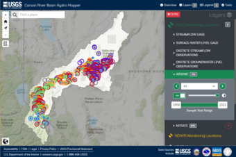
A new tool called the Carson River Basin Hydro Mapper (CBH) was created to help people access important water data. This tool shows current and past water levels measured by the U.S. Geological Survey (USGS) and the State of Nevada Division of Water Resources. It also includes information about groundwater, like nitrate and arsenic levels, collected by the USGS. Additionally, the CBH shows real-time streamflow and surface water levels for specific bodies of water. This tool makes it easy for resource managers, the public, and scientists to access and understand the latest information about water in the Carson River Basin.
Monitoring in the Carson River Basin
Studies in the Carson River Basin
- Evaluating the effects of groundwater management options on water resources in the Carson Valley
- Evaluating water-use patterns contributing to trends in Carson River streamflow and effects of climate change and future growth on water deliveries to Lahontan Reservoir
- Evaluation of Stream Capture in the Carson River Basin
- Assessment of Water Levels, Nitrate, and Arsenic in the Carson Valley Alluvial Aquifer and the Development of a Data Visualization Tool for the Carson River Basin, Nevada
- The distribution and modeling of nitrate transport in the Carson Valley alluvial aquifer, Douglas County, Nevada
- Assessing potential effects of changes in water use with a numerical groundwater-flow model of Carson Valley, Douglas County, Nevada, and Alpine County, California
- Integrated Hydrology and Operations Modeling to Evaluate Climate Change Impacts in an Agricultural Valley Irrigated With Snowmelt Runoff
Presentations
- Carson Valley: Monitoring, Status and Trends, Water Planning Tools
- Presentations related to East Fork and West Fork Carson River Headwater Flow models and Carson Valley Groundwater/Surface Water model
- Preliminary results: Effects of Water-Management Scenarios on Water Levels and Streamflow in the Carson River Basin
Available Water Data
Nevada Water Science Center projects in the Carson River Basin are linked below.

Monitoring Sediment and Water Quality in Clear Creek

Evaluation of Groundwater Flow in the Middle Carson River Basin, Eagle, Dayton, and Churchill Valleys, Nevada

Collection of arsenic and associated geochemical data important to occurrence and mobility of arsenic in groundwater used for public supply in southern Carson Valley, Douglas County, Nevada

Water for the Seasons

Chemical Quality of Water Deliveries to Stillwater National Wildlife Refuge, Nevada

Occurrence and Mobility of Arsenic in Groundwater Used for Public Supply in Southern Carson Valley, Douglas County, Nevada
The Carson River is an important water resource for residents, agriculture, and wildlife. The USGS provides science support on water quality and quantity, as well as on the impacts of climate change on water resources in the basin.
Geography
The Carson River Basin (State of Nevada hydrographic region 8) is nearly 4,000 square miles and stretches about 150 miles from Alpine County in eastern California to Pershing County in western Nevada. The Carson River Basin is a river-dominated hydrologic system, divided into three sub-basins: upper, middle, and lower.
At the headwaters, precipitation as snow and rain can produce runoff that is unregulated until it reaches Lahontan Reservoir. Water flowing in the mainstem may be diverted in Carson Valley for agriculture and for municipal uses. At Lahontan Reservoir, water imported from the Truckee River Basin via the Truckee Canal is used as needed to supplement natural inflows from the Carson River. Streamflow downstream of Lahontan is used for irrigation and supports habitat critical to migratory birds in the wetlands of the Stillwater National Wildlife Refuge.
Carson River Basin Hydro Mapper
A new tool called the Carson River Basin Hydro Mapper (CBH) was created to help people access important water data. This tool shows current and past water levels measured by the U.S. Geological Survey (USGS) and the State of Nevada Division of Water Resources. It also includes information about groundwater, like nitrate and arsenic levels, collected by the USGS. Additionally, the CBH shows real-time streamflow and surface water levels for specific bodies of water. This tool makes it easy for resource managers, the public, and scientists to access and understand the latest information about water in the Carson River Basin.
Monitoring in the Carson River Basin
Studies in the Carson River Basin
- Evaluating the effects of groundwater management options on water resources in the Carson Valley
- Evaluating water-use patterns contributing to trends in Carson River streamflow and effects of climate change and future growth on water deliveries to Lahontan Reservoir
- Evaluation of Stream Capture in the Carson River Basin
- Assessment of Water Levels, Nitrate, and Arsenic in the Carson Valley Alluvial Aquifer and the Development of a Data Visualization Tool for the Carson River Basin, Nevada
- The distribution and modeling of nitrate transport in the Carson Valley alluvial aquifer, Douglas County, Nevada
- Assessing potential effects of changes in water use with a numerical groundwater-flow model of Carson Valley, Douglas County, Nevada, and Alpine County, California
- Integrated Hydrology and Operations Modeling to Evaluate Climate Change Impacts in an Agricultural Valley Irrigated With Snowmelt Runoff
Presentations
- Carson Valley: Monitoring, Status and Trends, Water Planning Tools
- Presentations related to East Fork and West Fork Carson River Headwater Flow models and Carson Valley Groundwater/Surface Water model
- Preliminary results: Effects of Water-Management Scenarios on Water Levels and Streamflow in the Carson River Basin
Available Water Data
Nevada Water Science Center projects in the Carson River Basin are linked below.
Monitoring Sediment and Water Quality in Clear Creek
Evaluation of Groundwater Flow in the Middle Carson River Basin, Eagle, Dayton, and Churchill Valleys, Nevada
Collection of arsenic and associated geochemical data important to occurrence and mobility of arsenic in groundwater used for public supply in southern Carson Valley, Douglas County, Nevada
Water for the Seasons
Chemical Quality of Water Deliveries to Stillwater National Wildlife Refuge, Nevada