
New England WSC Products in the Second Quarter of 2026
By New England Water Science Center
June 25, 2026
List of products from the New England Water Science Center released in the second quarter of 2026.
Related
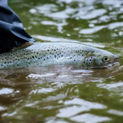
Thermal Imaging to Detect Cold-Water Habitat for Atlantic Salmon and Brook Trout at Katahdin Woods and Waters National Monument
The U.S. Geological Survey (USGS), in cooperation with the National Park Service (NPS), is using airborne thermal infrared remote sensing to characterize cold-water habitat for the federally designated endangered species Atlantic salmon ( Salmo salar) and wild brook trout ( Salvelinus fontinalis) in the East Branch of the Penobscot River system within Katahdin Woods and Waters National Monument...
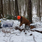
Statewide Studies of PFAS in Connecticut
The U.S. Geological Survey (USGS) New England Water Science Center, in cooperation with the Connecticut Department of Economic and Community Development (CT DECD) and the Connecticut Department of Energy and Environmental Protection (CT DEEP), is investigating the occurrence of per- and polyfluoroalkyl substances (PFAS) in soils and shallow groundwater across the state of Connecticut. The studies...
Related
Thermal Imaging to Detect Cold-Water Habitat for Atlantic Salmon and Brook Trout at Katahdin Woods and Waters National Monument
The U.S. Geological Survey (USGS), in cooperation with the National Park Service (NPS), is using airborne thermal infrared remote sensing to characterize cold-water habitat for the federally designated endangered species Atlantic salmon ( Salmo salar) and wild brook trout ( Salvelinus fontinalis) in the East Branch of the Penobscot River system within Katahdin Woods and Waters National Monument...
Statewide Studies of PFAS in Connecticut
The U.S. Geological Survey (USGS) New England Water Science Center, in cooperation with the Connecticut Department of Economic and Community Development (CT DECD) and the Connecticut Department of Energy and Environmental Protection (CT DEEP), is investigating the occurrence of per- and polyfluoroalkyl substances (PFAS) in soils and shallow groundwater across the state of Connecticut. The studies...