
Ecosystem
Ecosystem
Filter Total Items: 18
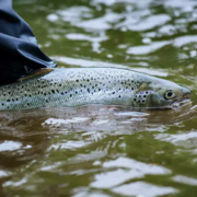
Thermal Imaging to Detect Cold-Water Habitat for Atlantic Salmon and Brook Trout at Katahdin Woods and Waters National Monument
The U.S. Geological Survey (USGS), in cooperation with the National Park Service (NPS), is using airborne thermal infrared remote sensing to characterize cold-water habitat for the federally designated endangered species Atlantic salmon ( Salmo salar) and wild brook trout ( Salvelinus fontinalis) in the East Branch of the Penobscot River system within Katahdin Woods and Waters National Monument...
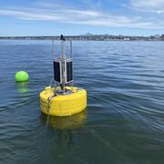
Coastal Water-Quality Monitoring in Massachusetts
The U.S. Geological Survey (USGS) operates high‑resolution, continuous water‑quality monitoring stations in estuaries across coastal Massachusetts to better understand these dynamic ecosystems. These efforts include collaborations with the Massachusetts Bays National Estuary Partnership (MassBays) and the Massachusetts Department of Environmental Protection (MassDEP) to support Clean Water Act...

Water Cycle Center
The Water Cycle Center is a cooperation between U.S. Geological Survey and academic partners in the Northeast that studies complete water cycles and watersheds, from mountaintops to shorelines, concentrating on freshwater ecosystems. This research advances the understanding of processes that determine water availability and is needed to best address future water resource challenges.

Assessment of Nutrient Transport and Discharge to Coastal Embayments, Wickford, Rhode Island
In 2020, the USGS began a partnership with the U.S. Environmental Protection Agency (EPA) Region 1 Southeast New England Program for Coastal Watershed Restoration (SNEP) and EPA Office of Research and Development (ORD), Atlantic Coastal Sciences Division, Narragansett, RI in support of water-quality and ecological monitoring being conducted by ORD in the coastal waters around Wickford, RI. The...

Monitoring Merrimack River Mainstem and Tidal Reaches in Massachusetts to Evaluate Water Quality Conditions, May to September 2020
The Merrimack River watershed, the 4th largest watershed in New England (Massachusetts Executive Office of Environmental Affairs, 2001), has seen substantial growth and development in recent years.

Water Quality Data Collection to Support Aluminum Criteria Development in Massachusetts
The U.S. Geological Survey (USGS) and Massachusetts Department of Environmental Protection (MassDEP) are collaborating on a study to collect water-quality data at streams and ponds in Massachusetts that receive aluminum discharges from wastewater treatment (WWTF) or public-water supply (PWS) facilities. The objective of this study is to inform the development of MassDEP guidelines on discharge...

Development of a Regional-Scale Model to Simulate Groundwater Flow and Nitrogen Loading in Watersheds Along the Connecticut Coast of Long Island Sound
In 2018 USGS began work on the development of regional-scale groundwater flow and nitrogen transport models of areas along the Connecticut coast. The model will be used as a quantitative tool to evaluate groundwater flow and nitrogen loading to Long Island Sound.

Assessment of Hydrologic and Water-Quality Changes in Shallow Groundwater Beneath a Coastal Neighborhood Being Converted from Septic Systems to Municipal Sewers
The U.S. Geological Survey and the U.S. Environmental Protection Agency are collaborating on a study to better understand changes to groundwater quality beneath a densely developed coastal neighborhood as it undergoes conversion from onsite wastewater disposal to municipal sewering.

Groundwater and Surface-Water Monitoring in the Mill Creek Watershed, Wellfleet and Truro, Massachusetts
The Herring River estuary and salt marsh system, within the Cape Cod National Seashore in Wellfleet, Massachusetts, has been diked off from the ocean for more than 100 years. The National Park Service is now preparing to restore the 1,100 acre estuary-marsh system.

Nutrient and Sediment Load Reduction Estimates from Intensive Street Cleaning and Leaf Litter Removal Practices in Vermont
Urban stormwater runoff contains high phosphorus concentrations that contribute to the eutrophication to receiving waters. Recent studies have further shown that leaf fall management presents an opportunity to maximize the effectiveness of common municipal practices such as street cleaning and leaf litter removal and substantially nutrient loading.

Characterization of Water Quality in the Sakonnet River, Rhode Island, 2018-19
Sections of Narragansett Bay and its eastern arm, the Sakonnet River, are considered impaired for shellfishing, aquatic habitat and recreational use by the State of Rhode Island. Aquatic habitat and water quality in the western portions of Narragansett Bay are relatively well understood, but there is comparably limited information available in the Sakonnet River. To address concerns about the lack...

The Influence of Climatic changes on Extreme Streamflows in the United States
Hydrologic droughts and floods can have severe impacts on river infrastructure, water supply, and ecosystem functioning.