
Advanced Capabilities and Modeling
Advanced Capabilities and Modeling
Filter Total Items: 40

Water Levels in the Ten Major Confined Aquifers of the New Jersey Coastal Plain
The Coastal Plain aquifers of New Jersey provide an important source of water for more than 3.5 million people. The USGS, in cooperation with the New Jersey Department of Environmental Protection, has been measuring water levels in the confined aquifers of the New Jersey Coastal Plain every five years beginning in 1978. Persistent, regionally extensive cones of depression are present in Ocean and...
City of Elizabeth Flood Mapping
To better protect the City of Elizabeth’s residents and assets, the U.S. Geological Survey (USGS) and Rutgers University proposed a joint collaboration to develop a reliable flood risk management platform with the cooperation of the City of Elizabeth and the New Jersey Office of Emergency Management. Our understanding is the broader goal for the City of Elizabeth is to accomplish three primary...

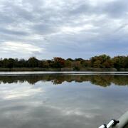
New Jersey Tide Network
The USGS operates the most extensive network of tide-gaging stations in the region, many of which form the backbone of flood-warning and storm-hazard warning systems. The New Jersey Water Science Center monitors data for estuary and back-bay areas all along the New Jersey coast and links to related projects with more information about coastal flood hazards, water quality, and other topics. This...

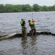
Flow Photo Explorer (FPE) Project in New Jersey
The Flow Photo Explorer (FPE) is a database, machine learning, and data visualization platform using timelapse images to develop new approaches for collecting hydrologic data in streams and other waterbodies where traditional monitoring methods are not feasible or cost-prohibitive. The Musconetcong River was chosen to participate in the early study, and we are expanding the work to other rivers.

USGS National Water Quality Network
Understanding the quality of U.S. streams, rivers, and groundwater requires consistent data collection and analysis over decades for proper context of current conditions. The USGS collects nationally standardized data and information as part of the National Water Quality Network (NWQN). The NQWN is made up of sites across the Nation where USGS scientists regularly measure water-quality conditions.
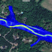
Flooded Roadway and Bridge Crossing Mapping and Early Warning System for Selected Communities in Hunterdon County, New Jersey
This project seeks to develop methods to identify when a flooded roadway or bridge crossing condition may exist and to provide a tool for users to select rainfall scenarios in addition to the selected river condition to estimate if road flooding may occur with the selected combination. These tools will provide officials in Hunterdon County and at the state level of management better early warning...

New Jersey Water Science Center Webcams
Static webcams have been installed at a number of real-time stream-gaging locations in New Jersey to allow you to view the current river-stage conditions. These webcams provide valuable information to the National Weather Service, emergency managers, and area residents to evaluate real-time conditions in river and coastal environments during storms.

Manning's Roughness Coefficient for New Jersey Streams
Manning’s Roughness Coefficient (n) is an input to the Manning’s Equation, which can be used for the computation of streamflow during times it is impractical or impossible to make a measurement. Methods and regional equations for determining the value of n have largely been developed in the western United States; New Jersey is comparatively unstudied. New Jersey features a diverse range of...
Novel Bacterial Monitoring of Urbanized Waterways in the Lower Delaware River and Passaic River Basins.
As part of the Urban Water Federal Partnership, the U.S. Geological Survey (USGS) New Jersey Water Science Center (NJWSC) is currently assessing the use of innovative, near real-time bacteria monitoring technology to provide rapid results on bacteria concentrations to water regulators. Traditional methods of collecting and quantifying fecal indicator bacteria (FIB) is labor intensive, expensive...

New Jersey Subbasin Paired Air & Stream Water Temperature Networks
The temperature, water quality, and channel connectivity along headwater stream networks often show highly dynamic spatiotemporal patterns that are tied to localized hydrogeologic and landcover controls. Groundwater exchanges exert a spatially discontinuous influence on streams that reflect, in part, the preferential nature of groundwater discharge as controlled by recharge, topography, and...

New Jersey: Coastal Flood Inundation Mapping
The U.S. Geological Survey (USGS) in cooperation with the New Jersey Department of Environmental Protection and New Jersey Office of Emergency Management conducted a study to produce flood-inundation maps for storm surge flooding scenarios in the coastal areas of 10 New Jersey counties. The coastal storm-surge inundation maps were created from data modelled in the FEMA Region II Coastal Storm...

Program to Maintain and Update Groundwater Models
The Model Maintenance program, in cooperation with the N.J. Department of Environmental Protection (NJDEP), archives, maintains, updates, and shares groundwater-flow models that have been developed by the New Jersey Water Science Center (NJWSC). The program was started in 1995 to maintain existing groundwater flow models, use standardized procedures to archive the models, update models with recent...