
Environmental Geoscience
Environmental Geoscience
The Environmental Geoscience Unit approaches scientific questions from a broad perspective, combining multiple areas of expertise to understand water in New Mexico and the Nation. Capabilities include water quality trend analysis, assessment of sediment loads and mining impacts on water, geochemical fingerprinting of sediment and water, and use unmanned aircraft systems for land surface analyses.
Filter Total Items: 32
Investigating PCB, PFAS, and Microplastics in Urban Runoff Contributing to the Rio Grande near Albuquerque, New Mexico
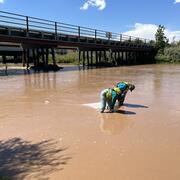
Stormwater outfalls in Albuquerque collect urban runoff from precipitation events which include physical materials and chemical contaminants that contribute directly into the Rio Grande. Among these contaminants are polychlorinated biphenyls (PCB), and per- and polyfluoroalkyl substances (PFAS), present in consumer and industrial products, some of which were banned decades ago but are still found...

Assessment of Per- and Polyfluoroalkyl Substances in Water Resources of New Mexico
Per- and polyfluoroalkyl substances (PFAS) are widespread anthropogenic chemicals that have been in use for the past 70 years. This class of compounds comprises thousands of chemicals including perfluorosulfonates (PFSAs) such as perfluorooctane sulfonate (PFOS), perfluorocarboxylic acids (PFCAs), and perfluorooctanoic acid (PFOA). As the use of these chemicals has grown so has their ubiquity in...

Investigations of Sources of Contaminants of Concern in the San Juan River
Metals attached to suspended sediments or dissolved in river water pose a potential health risk to communities that depend on that water for agricultural and domestic uses. Exceedances of Navajo Nation surface water quality standards for metals (especially lead and arsenic) indicate that communities on the Navajo Nation along the San Juan River are exposed to this potential risk. Sources for these...
Microbial Source Tracking and Escherichia coli Monitoring in the Rio Grande in the South Valley, Albuquerque, New Mexico
The Rio Grande, in southern Albuquerque, is an impaired reach for bacteria. Escherichia coli (E. coli) bacteria are elevated in this reach of the Rio Grande even without stormwater present, during what is referred to as “dry season”. Samples will be collected over a range of flows including during the dry season (November 1st-June30th). Water samples will be analyzed for E. coli and microbial...

Investigating Polychlorinated Biphenyl (PCB) Concentrations and Loads in Albuquerque Stormwater Channels
In cooperation with the New Mexico County of Bernalillo, the U.S. Geological Survey (USGS) characterized polychlorinated biphenyl (PCB) concentrations and estimated potential loading into the Rio Grande from urban watersheds that are under the county’s jurisdiction. Water and sediment samples were collected in 2017-18 from six sites within four stormwater drainage basins in the Albuquerque, New...

Ecohydrologic and Water Quality Data Collection at Valle de Oro National Wildlife Refuge and the Albuquerque South Valley Community Commons
The United States Geological Survey (USGS) New Mexico Water Science Center (NM WSC), in cooperation with the U.S. Fish and Wildlife Service (USFWS), U.S. Environmental Protection Agency (USEPA), U.S. Army Corps of Engineers (USACE), U.S. Bureau of Reclamation (Reclamation), Albuquerque Metropolitan Arroyo Flood Control Authority (AMAFCA), and Bernalillo County (BERNCO), will measure and analyze...

Geochemical Evidence of Groundwater Flow Paths and the Fate and Transport of Constituents of Concern in the Alluvial Aquifer at Fort Wingate Depot Activity, New Mexico
As part of an environmental investigation at Fort Wingate Depot Activity, New Mexico, the U.S. Geological Survey, in cooperation with the U.S. Army Corps of Engineers, interpreted aqueous geochemical concentrations to better understand the groundwater flow paths and the fate and transport of constituents of concern in the alluvial aquifer underlying the study area. The fine-grained nature of the...

Hydrogeologic and geochemical characterization and evaluation of two arroyos for managed aquifer recharge by surface infiltration in the Pojoaque River Basin
In order to provide long-term storage of diverted surface water from the Rio Grande as part of the Aamodt water rights settlement, managed aquifer recharge by surface infiltration in Pojoaque River Basin arroyos was proposed as an option. The initial hydrogeologic and geochemical characterization of two arroyos located within the Pojoaque River Basin was performed in 2014 and 2015 in cooperation...

The Source of Groundwater and Solutes to Many Devils Wash at a Former Uranium Mill Site in Shiprock, New Mexico
The Shiprock Disposal Site is the location of the former Navajo Mill, a uranium ore-processing facility, located on a terrace overlooking the San Juan River in the town of Shiprock, New Mexico.The milling operations, conducted at the site from 1954 to 1968, created radioactive tailings and constituents of concern that are now found in the groundwater beneath the Mill. Elevated concentrations of...

Simulation of Pre- and Post-Fire Streamflow in the Upper Rio Hondo Basin, NM
The 2012 Little Bear Fire burned 44,000 acres in the upper Rio Hondo Basin in south-central New Mexico. Landscape in the Basin ranges from mixed conifer forests at higher elevations (12,000 ft) to desert shrubland at lower (5,200 ft) elevations. Burned areas are at risk of substantial post-wildfire erosion and flash floods. USGS post-wildfire analysis estimated 70% of the burned area had a high...

Assessment of Hydrologic Resources and the Potential Effects from Oil and Gas Development in the U.S. Bureau of Land Management Tri-County Planning Area, Sierra, Doña Ana, and Otero Counties, New Mexico
The Tri-County Resource Management Plan/Environmental Impact Statement (RMP/EIS) “decision area” (the public lands and resources that are managed by the Bureau of Land Management in Sierra, Doña Ana, and Otero Counties) is a large (4,375 square miles) and varied landscape. The decision area contains both connected and closed surface-water and groundwater basins, some of which cross state and...

USGS Data Collection: Real-Time Rain Gages for Post Conchas-Fire Flood-Early Warning System
The Las Conchas fire started on June 26, 2011, near the small community of Las Conchas in the Jemez Mountains of north-central New Mexico. When the fire was contained on August 3, 2011, it had burned 156,593 acres of mixed conifer, pinyon/juniper, and ponderosa forest. At the time, it was the largest wildfire in New Mexico history. Peak burn severity was extreme; over 60,000 acres of the total...