



The 6 components that comprise READI-Net are each represented by an interlocking hexagon, illustrating the multi-dimensional aspect of the project including: Autonomous eDNA samplers, Broad spectrum surveillance, Where & when to sample, Lab analysis standards, Information framework, and Communication.
Images
Images intro.
Filter Total Items: 465

READI-Net infographic_white
The 6 components that comprise READI-Net are each represented by an interlocking hexagon, illustrating the multi-dimensional aspect of the project including: Autonomous eDNA samplers, Broad spectrum surveillance, Where & when to sample, Lab analysis standards, Information framework, and Communication.

READI-Net infographic_6 polygon
The 6 components that comprise READI-Net are each represented by an interlocking hexagon, illustrating the multi-dimensional aspect of the project including: Autonomous eDNA samplers, Broad spectrum surveillance, Where & when to sample, Lab analysis standards, Information framework, and Communication.
The 6 components that comprise READI-Net are each represented by an interlocking hexagon, illustrating the multi-dimensional aspect of the project including: Autonomous eDNA samplers, Broad spectrum surveillance, Where & when to sample, Lab analysis standards, Information framework, and Communication.

Big Sheep Canyon, Red Rock Lakes National Wildlife Refuge, Montana
Big Sheep Canyon, Red Rock Lakes National Wildlife Refuge, MontanaBig Sheep Canyon, Red Rock Lakes National Wildlife Refuge, Centennial Mountains, southern Montana.
Big Sheep Canyon, Red Rock Lakes National Wildlife Refuge, Montana
Big Sheep Canyon, Red Rock Lakes National Wildlife Refuge, MontanaBig Sheep Canyon, Red Rock Lakes National Wildlife Refuge, Centennial Mountains, southern Montana.

eDNA sampler filter with turbid sample
A filter from the Smith-Root sampler that collects eDNA when water is pushed through. This pattern is indicative of turbid water passing through the filter.
A filter from the Smith-Root sampler that collects eDNA when water is pushed through. This pattern is indicative of turbid water passing through the filter.

Photographing bumble bees
USGS field technician photographing bumble bees captured during monitoring surveys at Logan Pass, Glacier National Park, Montana.
USGS field technician photographing bumble bees captured during monitoring surveys at Logan Pass, Glacier National Park, Montana.

Western bumble bee on a sticky purple geranium flower
Western bumble bee on a sticky purple geranium flowerWestern bumble bee on a Geranium viscossium (sticky purple geranium) flower in Glacier National Park, Montana. Photo taken by USGS field crew in July 2023.
Western bumble bee on a sticky purple geranium flower
Western bumble bee on a sticky purple geranium flowerWestern bumble bee on a Geranium viscossium (sticky purple geranium) flower in Glacier National Park, Montana. Photo taken by USGS field crew in July 2023.
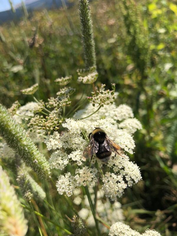
Western bumblebee on a yarrow flower
Western bumblebee on a yarrow flower in Glacier National Park, Montana.
Western bumblebee on a yarrow flower in Glacier National Park, Montana.

Western bumble bee on a common yarrow flower
Western bumble bee on a common yarrow flower in Glacier National Park, Montana. Photo taken by USGS field crew in July 2023.
Western bumble bee on a common yarrow flower in Glacier National Park, Montana. Photo taken by USGS field crew in July 2023.
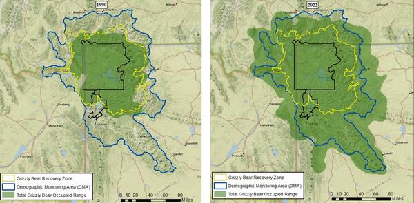
Occupied range of grizzly bears in the Greater Yellowstone Ecosystem: 1990 vs. 2022
Occupied range of grizzly bears in the Greater Yellowstone Ecosystem: 1990 vs. 2022The grizzly bear distribution represents the estimated geographic extent of occupied range of the Yellowstone grizzly bear population. The images show a comparison of their estimated geographic extent, with a 3-fold increase from 1990 (23,361 km2 or 9,020 mi2) to 2022 (70,101 km2 or 27,066 mi2).
Occupied range of grizzly bears in the Greater Yellowstone Ecosystem: 1990 vs. 2022
Occupied range of grizzly bears in the Greater Yellowstone Ecosystem: 1990 vs. 2022The grizzly bear distribution represents the estimated geographic extent of occupied range of the Yellowstone grizzly bear population. The images show a comparison of their estimated geographic extent, with a 3-fold increase from 1990 (23,361 km2 or 9,020 mi2) to 2022 (70,101 km2 or 27,066 mi2).
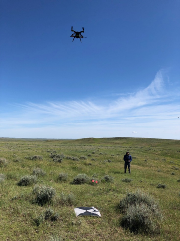
Researcher collecting data with unmanned aerial vehicle (drone)
Researcher collecting data with unmanned aerial vehicle (drone)USGS researchers acquire imagery from unmanned aerial vehicles (drones) synchronous with high-resolution imagery from satellites to map sagebrush across North Dakota and South Dakota.
Researcher collecting data with unmanned aerial vehicle (drone)
Researcher collecting data with unmanned aerial vehicle (drone)USGS researchers acquire imagery from unmanned aerial vehicles (drones) synchronous with high-resolution imagery from satellites to map sagebrush across North Dakota and South Dakota.

Montana creek were eDNA autosampler was deployed
Cherry Creek, Montana—a location where an environmental DNA (eDNA) autosampler was placed to detect invasive species.
Cherry Creek, Montana—a location where an environmental DNA (eDNA) autosampler was placed to detect invasive species.

USGS researcher collecting data on a snow sample
Northern Rocky Mountain Science Center scientist examining a snow sample while standing in a snow pit to better understand snowpack characteristics that lead to avalanches.
Northern Rocky Mountain Science Center scientist examining a snow sample while standing in a snow pit to better understand snowpack characteristics that lead to avalanches.

Helicopter used to assist in wildlife research
Helicopter used to assist in mule deer capture to fit animals with GPS collars in Wind River Basin, Wyoming.
Helicopter used to assist in mule deer capture to fit animals with GPS collars in Wind River Basin, Wyoming.
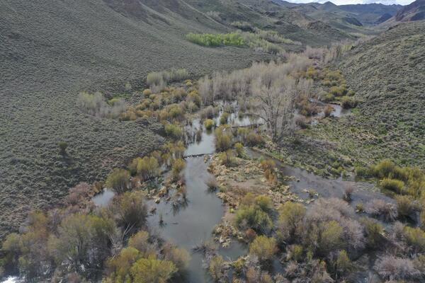
Section of the St. Mary River
Section of the St. Mary River near border of Montana and Canada flowing through sagebrush and juniper with cottonwoods and willow at its banks.
Section of the St. Mary River near border of Montana and Canada flowing through sagebrush and juniper with cottonwoods and willow at its banks.

South Cascade Glacier, Washington
The surface of South Cascade Glacier, Washington is mostly exposed ice at the end of summer melt season.
The surface of South Cascade Glacier, Washington is mostly exposed ice at the end of summer melt season.

USGS scientist examines a snow core
USGS scientist examines a snow core collected on South Cascade Glacier, Washington.
USGS scientist examines a snow core collected on South Cascade Glacier, Washington.

Bat passive acoustic recording device
This passive acoustic recording device has been deployed in Montana (MT) as part of the North American Bat Monitoring Programs (NABat) summertime survey efforts. It has an ultrasonic microphone placed at the top of a 10ft pole that records echolocating bats fro
This passive acoustic recording device has been deployed in Montana (MT) as part of the North American Bat Monitoring Programs (NABat) summertime survey efforts. It has an ultrasonic microphone placed at the top of a 10ft pole that records echolocating bats fro

Environmental DNA sampler in workshop
An inside look at an MBARI autonomous environmental DNA (eDNA) sampler that is normally in metal housing taking samples in streams to detect aquatic invasive species, pathogens, and parasites. This version weighs about 400 pounds, but future versions will be more portable.
An inside look at an MBARI autonomous environmental DNA (eDNA) sampler that is normally in metal housing taking samples in streams to detect aquatic invasive species, pathogens, and parasites. This version weighs about 400 pounds, but future versions will be more portable.

Montana trout fishing
Boaters fly fishing on the Missouri River in Montana
Boaters fly fishing on the Missouri River in Montana

Wind turbines in Wyoming
A group of wind turbines in northeast Wyoming on a cloudy day. (Photo taken in May 2022.)
A group of wind turbines in northeast Wyoming on a cloudy day. (Photo taken in May 2022.)

Mountain goat in Glacier National park
Mountain goat standing next to a mostly frozen, high-elevation lake in Glacier National Park, Montana.
Mountain goat standing next to a mostly frozen, high-elevation lake in Glacier National Park, Montana.