
Watershed/Basin Studies
Watershed/Basin Studies
Filter Total Items: 48

Understanding Groundwater in Oregon
Oregon Water Resources Department (OWRD) and U.S. Geological Survey (USGS) are working together to estimate groundwater recharge across the state.

Water-quality monitoring during reservoir drawdowns
The USGS is monitoring water-quality above, within, and below Middle Fork Willamette and the South Santiam River dams using field-based and remote-sensing approaches to understand how reservoir drawdowns influence downstream water-quality conditions.

Willamette Focused Investment Partnership Restoration Effectiveness Monitoring Program
The USGS, in collaboration with several Willamette River Basin partners, led a multi-phase program to assess the effectiveness of restoration efforts aimed at improving native fish habitat in the Willamette River. The Willamette Focused Investment Partnership Restoration Effectiveness Monitoring Program evaluates whether restoration projects achieved their targets to improve physical floodplain...

Water Quality in Keno Reach of the Klamath River
The U.S. Geological Survey, U.S. Bureau of Reclamation, and Watercourse Engineering, Inc. are collaborating to develop knowledge and tools to better manage water quality in the Link-Keno reach of the Klamath River and the Lost River.

City Beavers: Tualatin River Basin Beaver Study
Beavers and their dams are common sights along creeks in the Tualatin River basin. Beaver help create diverse habitats for many other animals, including birds, fish, and amphibians. The USGS studying the affect beaver activity has on the amount and quality of water in local streams, so that agencies in the basin can make strategic management and habitat restoration decisions based on science.
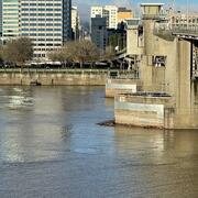
The “Super Monitor”: Tracking Willamette River water quality in Portland
Nicknamed the ‘Super Monitor,’ this site has measured key water-quality values every 15 minutes since 2009.

Tualatin River Basin Water Quality Assessment
In 1990, the USGS began assessing water-quality in the Tualatin River. More then 30 years later, we are still monitoring conditions in the basin and conducting investigations to better understand stream processes within the basin.

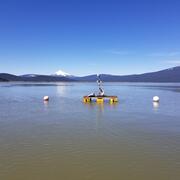
Nutrient and Sediment Loading to Upper Klamath Lake
The U.S. Geological Survey (USGS) computes time-series of total phosphorus (TP) and suspended-sediment concentrations (SSC) and loads entering Upper Klamath Lake using continuous turbidity sensor records, discrete TP and SSC data, and continuously computed streamflow.
Integrating water availability in the Klamath Basin: from drought to dam removal
The USGS Water Resources Mission Area is assessing how much water is available for human and ecological needs in the United States and identifying where and when the Nation may have challenges meeting its demand for water. This information helps decision makers manage and distribute water in ways that balance competing needs. Due to its complex and competing water demands, ecological significance...

Prey Availability
Migratory wildlife need to balance the benefits of migration and reproduction with the physiological costs. This is particularly challenging in dynamic environments like wetlands, where food levels can vary greatly from year to year. For shorebirds in the Great Basin region, saline or terminal lakes provide essential habitats during their annual life cycle. To understand how changes in hydrology...
By
Ecosystems Mission Area, Water Resources Mission Area, Species Management Research Program, Forest and Rangeland Ecosystem Science Center, Fort Collins Science Center, Nevada Water Science Center, Oregon Water Science Center, Utah Water Science Center, Western Ecological Research Center (WERC), Saline Lake Ecosystems Integrated Water Availability Assessment

New gages for understanding surface water availability and spring Chinook salmon habitat in the Willamette Basin
Learn about our new streamgages in the Williamette River Basin.

Surface-water extent in the Klamath Marsh
Satellite imagery and the interplay of climate and hydrologic data tell the story of surface-water decline in the Klamath Marsh.