
Surface Water
Surface Water
Steamflow monitoring, Shohola Creek near Walker Lake, PA (01432495)
Steamflow monitoring, Shohola Creek near Walker Lake, PA (01432495)
Updating Pennsylvania Streamgage Datums
USGS is updating streamgage datums to reflect elevations in North American Vertical Datum of 1988 (NAVD88)
USGS is updating streamgage datums to reflect elevations in North American Vertical Datum of 1988 (NAVD88)
Surface water science for Pennsylvania, or conducted by center staff.
Filter Total Items: 11
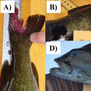
A regional assessment of fish health in the Chesapeake Bay watershed
Fish diseases in freshwater ecosystems pose significant ecological and socioeconomic challenges; yet, monitoring them in wild populations is complex due to interactions between pathogens, hosts, and environmental conditions. External DELT (deformity, erosion, lesion, tumor, and parasite) data (fig. 1) provide a rapid and broad measure of fish health but are a relatively coarse indicator that...

Three Rivers Region Water Quality Monitoring with Allegheny County Sanitary Authority
USGS, in cooperation with the Allegheny County Sanitary Authority (ALCOSAN), is monitoring water quality changes related to wastewater infrastructure improvements in the Three Rivers region in Pittsburgh, Pennsylvania.

Susquehanna River and Basin
In Pennsylvania, the USGS's water-resources roots date back to the late 1800's, with the initiation of streamflow gaging on the Susquehanna and Delaware Rivers and assessments of groundwater resources near Philadelphia. The USGS Pennsylvania Water Science Center continues to provide scientific information about the water resources of the Susquehanna River Basin, in cooperation with regional and...

Rapid Deployment Network for Flooding in Pennsylvania
USGS, in cooperation with the Federal Emergency Management Agency (FEMA) Region 3 and the Pennsylvania Department of Transportation (PennDOT), is developing a Rapid Deployment Network (RDN) for monitoring stream levels at currently unmonitored locations in Pennsylvania during flooding. RDN data helps emergency response agencies protect life and property during forecast floods and informs flood...

Surface Water Monitoring in Pennsylvania
Surface Water Data and Monitoring tools for Pennsylvania

Sediment Response of Stream Restoration Practices, Turtle Creek, Union County, Pennsylvania
USGS is providing data and analyses to assess stream restoration effectiveness in Turtle Creek, Union County, Pennsylvania, by measuring differences in sediment erosion and deposition in restored and eroded stream reaches.

Paired Air and Water Temperature Monitoring for Next Generation Water Observing System
USGS characterizes the relationship between a stream's water temperature and the surrounding air temperature to understand the influence groundwater flow into and out of the stream has on that relationship.

Pennsylvania StreamStats
StreamStats is a national web-based application that provides selected water-resource information for Pennsylvania. Users can easily obtain descriptive information, basin characteristics, and streamflow statistics for USGS streamgages and ungaged stream locations throughout the Commonwealth.

Pennsylvania Super Gages
What is a Super Gage? A gage at which continuous flow and water level are determined, along with continuous traditional water-quality (water temperature, specific conductance, pH, dissolved oxygen, and/or turbidity) and either of the following criteria: at least one other less-traditional continuous water-quality parameter (orthophosphate, nitrate concentration) and/or where surrogates (developed...

Streamflow Estimation from Advanced Imaging (LSPIV) in Pennsylvania
Pennsylvania Water Science Center and the Next Generation Water Observing Systems (NGWOS) Program are implementing new technologies for streamflow estimation at sites in Pennsylvania where conventional measurement techniques are inadequate.

Webcams at streamgages in Pennsylvania
The Pennsylvania Water Science Center hosts webcams at several streamgaging sites.