
USGS scientists produced an animated GIF in coordination with the California Department of Transportation (Caltrans) re-opening of State Highway 1 through Big Sur on July 18, 2018. In 2017, the massive Mud Creek landslide buried a quarter-mile of the famous coastal route with rocks and dirt more than 65 feet deep.
Information about USGS Pacific Coastal and Marine Science Center studies on coastal landslides in the Big Sur area
Media

Sources/Usage: Public Domain. View Media Details
The Mud Creek landslide on California’s Big Sur coast
On May 20, 2017, the steep slopes at Mud Creek on California’s Big Sur coast, about 140 miles south of San Francisco, suffered a catastrophic collapse. USGS Scientists from the Pacific Coastal and Marine and the Geology, Minerals, Energy, and Geophysics Science Centers are monitoring this section of the coastline, in collaboration with the California Department of Transportation.
Maps Showing Estimated Sediment Yield From Coastal Landslides and Active Slope Distribution Along the Big Sur Coast, Monterey and San Luis Obispo Counties, California
- USGS Scientific Investigations Map 2852
Map Showing Coastal Cliff Retreat Rates Along the Big Sur Coast, Monterey and San Luis Obispo Counties, California
- USGS Scientific Investigations Map 2853
Formation, Evolution, and Stability of Coastal Cliffs--Status and Trends
- USGS Professional Paper 1693
USGS Landslide Hazards website
USGS Landslide News and Information
1982-83 El Niño Coastal Erosion: San Mateo County, California
Learn about related USGS projects.

Remote Sensing Coastal Change
We use remote-sensing technologies—such as aerial photography, satellite imagery, structure-from-motion (SfM) photogrammetry, and lidar (laser-based surveying)—to measure coastal change along U.S. shorelines.

Big Sur Landslides
On California’s Big Sur coast, the steep slopes at Mud Creek suffered a catastrophic collapse (May 20, 2017). On January 28, 2021, heavy rains from a two-day storm caused debris from fire-scarred slopes to wash out another section of road at Rat Creek. USGS scientists are monitoring this 100-mile section of the California coastline, in collaboration with the CA Department of Transportation.

The Mud Creek landslide on California’s Big Sur coast
On May 20, 2017, the steep slopes at Mud Creek on California’s Big Sur coast, about 140 miles south of San Francisco, suffered a catastrophic collapse. USGS Scientists from the Pacific Coastal and Marine and the Geology, Minerals, Energy, and Geophysics Science Centers are monitoring this section of the coastline, in collaboration with the California Department of Transportation.
Below are multimedia items associated with this project.

Mud Creek landslide changes March 2017-June 2018
USGS scientists produced an animated GIF in coordination with the California Department of Transportation (Caltrans) re-opening of State Highway 1 through Big Sur on July 18, 2018. In 2017, the massive Mud Creek landslide buried a quarter-mile of the famous coastal route with rocks and dirt more than 65 feet deep.
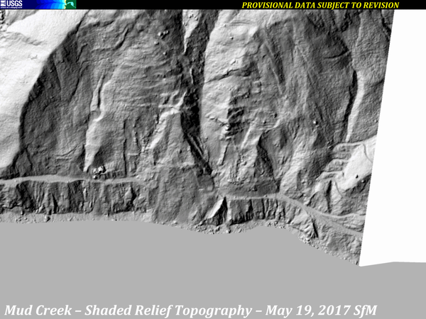
Mud Creek Shaded-Relief Topography, 2010-2017
A series of images from various sources of shaded-relief topography show the progression of the Mud Creek landslide area, from 2010 through October 12, 2017.
Sources:
A series of images from various sources of shaded-relief topography show the progression of the Mud Creek landslide area, from 2010 through October 12, 2017.
Sources:

Mud Creek – 3D Point Cloud – Oblique Perspective
Video shot from drones yields details about changing landslide on California’s Big Sur coast
Video shot from drones yields details about changing landslide on California’s Big Sur coast

Big Sur Coast
Near San Simeon, view looks north up Highway 1 along the California coast toward Big Sur.
Near San Simeon, view looks north up Highway 1 along the California coast toward Big Sur.

Big Sur Landslide, July 7, 2017
USGS scientists continue to monitor the slide by collecting imagery every couple of weeks, weather permitting. Pilot Bob Van Wagenen, contracted through the Department of the Interior’s Office of Aviation Services, takes air photos for Jon Warrick’s Big Sur Landslide team, flying out of the Watsonville Municipal Airport in a Cessna 182R.
USGS scientists continue to monitor the slide by collecting imagery every couple of weeks, weather permitting. Pilot Bob Van Wagenen, contracted through the Department of the Interior’s Office of Aviation Services, takes air photos for Jon Warrick’s Big Sur Landslide team, flying out of the Watsonville Municipal Airport in a Cessna 182R.

Big Sur Coastal Landslides
Large-scale poster describing USGS work.
The USGS studied air photos of the Big Sur coast taken in 1942 and 1994, in cooperation with the California Department of Transportation (Caltrans) and the University of California at Santa Cruz (UCSC).
Large-scale poster describing USGS work.
The USGS studied air photos of the Big Sur coast taken in 1942 and 1994, in cooperation with the California Department of Transportation (Caltrans) and the University of California at Santa Cruz (UCSC).
Information about USGS Pacific Coastal and Marine Science Center studies on coastal landslides in the Big Sur area
Media
Sources/Usage: Public Domain. View Media Details
The Mud Creek landslide on California’s Big Sur coast
On May 20, 2017, the steep slopes at Mud Creek on California’s Big Sur coast, about 140 miles south of San Francisco, suffered a catastrophic collapse. USGS Scientists from the Pacific Coastal and Marine and the Geology, Minerals, Energy, and Geophysics Science Centers are monitoring this section of the coastline, in collaboration with the California Department of Transportation.
Maps Showing Estimated Sediment Yield From Coastal Landslides and Active Slope Distribution Along the Big Sur Coast, Monterey and San Luis Obispo Counties, California
- USGS Scientific Investigations Map 2852
Map Showing Coastal Cliff Retreat Rates Along the Big Sur Coast, Monterey and San Luis Obispo Counties, California
- USGS Scientific Investigations Map 2853
Formation, Evolution, and Stability of Coastal Cliffs--Status and Trends
- USGS Professional Paper 1693
USGS Landslide Hazards website
USGS Landslide News and Information
1982-83 El Niño Coastal Erosion: San Mateo County, California
Learn about related USGS projects.
Remote Sensing Coastal Change
We use remote-sensing technologies—such as aerial photography, satellite imagery, structure-from-motion (SfM) photogrammetry, and lidar (laser-based surveying)—to measure coastal change along U.S. shorelines.
Big Sur Landslides
On California’s Big Sur coast, the steep slopes at Mud Creek suffered a catastrophic collapse (May 20, 2017). On January 28, 2021, heavy rains from a two-day storm caused debris from fire-scarred slopes to wash out another section of road at Rat Creek. USGS scientists are monitoring this 100-mile section of the California coastline, in collaboration with the CA Department of Transportation.
The Mud Creek landslide on California’s Big Sur coast
On May 20, 2017, the steep slopes at Mud Creek on California’s Big Sur coast, about 140 miles south of San Francisco, suffered a catastrophic collapse. USGS Scientists from the Pacific Coastal and Marine and the Geology, Minerals, Energy, and Geophysics Science Centers are monitoring this section of the coastline, in collaboration with the California Department of Transportation.
Below are multimedia items associated with this project.
Mud Creek landslide changes March 2017-June 2018
USGS scientists produced an animated GIF in coordination with the California Department of Transportation (Caltrans) re-opening of State Highway 1 through Big Sur on July 18, 2018. In 2017, the massive Mud Creek landslide buried a quarter-mile of the famous coastal route with rocks and dirt more than 65 feet deep.
USGS scientists produced an animated GIF in coordination with the California Department of Transportation (Caltrans) re-opening of State Highway 1 through Big Sur on July 18, 2018. In 2017, the massive Mud Creek landslide buried a quarter-mile of the famous coastal route with rocks and dirt more than 65 feet deep.
Mud Creek Shaded-Relief Topography, 2010-2017
A series of images from various sources of shaded-relief topography show the progression of the Mud Creek landslide area, from 2010 through October 12, 2017.
Sources:
A series of images from various sources of shaded-relief topography show the progression of the Mud Creek landslide area, from 2010 through October 12, 2017.
Sources:
Mud Creek – 3D Point Cloud – Oblique Perspective
Video shot from drones yields details about changing landslide on California’s Big Sur coast
Video shot from drones yields details about changing landslide on California’s Big Sur coast
Big Sur Coast
Near San Simeon, view looks north up Highway 1 along the California coast toward Big Sur.
Near San Simeon, view looks north up Highway 1 along the California coast toward Big Sur.
Big Sur Landslide, July 7, 2017
USGS scientists continue to monitor the slide by collecting imagery every couple of weeks, weather permitting. Pilot Bob Van Wagenen, contracted through the Department of the Interior’s Office of Aviation Services, takes air photos for Jon Warrick’s Big Sur Landslide team, flying out of the Watsonville Municipal Airport in a Cessna 182R.
USGS scientists continue to monitor the slide by collecting imagery every couple of weeks, weather permitting. Pilot Bob Van Wagenen, contracted through the Department of the Interior’s Office of Aviation Services, takes air photos for Jon Warrick’s Big Sur Landslide team, flying out of the Watsonville Municipal Airport in a Cessna 182R.
Big Sur Coastal Landslides
Large-scale poster describing USGS work.
The USGS studied air photos of the Big Sur coast taken in 1942 and 1994, in cooperation with the California Department of Transportation (Caltrans) and the University of California at Santa Cruz (UCSC).
Large-scale poster describing USGS work.
The USGS studied air photos of the Big Sur coast taken in 1942 and 1994, in cooperation with the California Department of Transportation (Caltrans) and the University of California at Santa Cruz (UCSC).