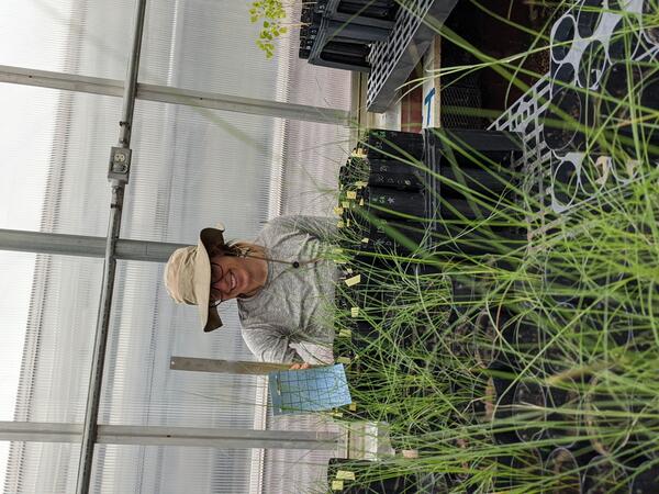
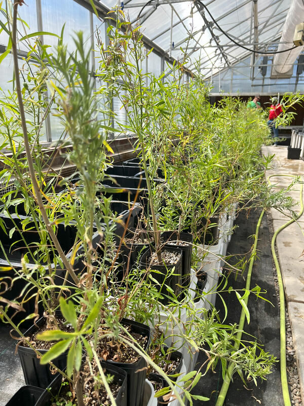
U.S. flag

An official website of the United States government

Images

Below are images associated with SBSC's science and staff. Images appear according to the year they were taken. To search, type a keyword or select a year from the dropdown menu. Or, click through the pages using the arrows at the bottom of the page. 

Filter Total Items: 641
A person fishing in Lees Ferry on the Colorado River downstream of Glen Canyon Dam in the late afternoon
A person fishing for trout in Lees Ferry, Colorado River

A person fishing for rainbow trout or brown trout in the Lees Ferry fishery in the Colorado River downstream of Glen Canyon Dam in Grand Canyon National Park.

Three rainbow trout swimming upstream in the Colorado River
Rainbow trout in Lees Ferry, Colorado River

A group of rainbow trout swims upstream in the Lees Ferry fishery downstream of Glen Canyon Dam in the Colorado River. 

A flowering Arrowweed plant with a few clusters of pink flowers and stalks with thin, sage-green slightly fuzzy leaves
Flowering Arrowweed (Pluchea sericea), in a riparian plant experiment

Flowering Arrowweed (Pluchea sericea) in a riparian plant experiment in a greenhouse, to assess how flooding or drought can affect this native stream-dependent species. Arrowweed is one of the species that grows abundantly along the Colorado River in Grand Canyon. Photo by Emily Palmquist, USGS.

Flowering Arrowweed (Pluchea sericea) in a riparian plant experiment in a greenhouse, to assess how flooding or drought can affect this native stream-dependent species. Arrowweed is one of the species that grows abundantly along the Colorado River in Grand Canyon. Photo by Emily Palmquist, USGS.

Biocrust study site
Biocrust survey study site

USGS SBSC staff surveying biocrust at a protected study site. Photo courtesy of Mike Duniway, Sept 2019.

USGS SBSC staff surveying biocrust at a protected study site. Photo courtesy of Mike Duniway, Sept 2019.

Grassland in Canyonlands National Park

USGS scientists measure biological soil crust cover in the study grassland.

SBSC researchers conducting aquatic insect research by Glen Canyon Dam in the Colorado River
SBSC researchers conducting aquatic insect research in the Colorado River next to Glen Canyon Dam during "Bug Flows"

SBSC's foodbase team conducts aquatic insect studies downstream of Glen Canyon Dam in the Colorado River during "Bug Flows" - a modified flow regime designed to benefit insects.

People fishing in the water and from a boat in the greenish waters of the Colorado River, Lees Ferry
People fishing at Lees Ferry on the Colorado River

Fishing at dusk at Lees Ferry on the Colorado River, Glen Canyon. Photo by David Herasimtschuk, Freshwaters Illustrated. 

Group of people learning about native plants
Supporting Tribal Seed Sovereignty

USGS Restoration Assessment and Monitoring Program for the Southwest (RAMPS) is helping to build capacity in ecosystem restoration on the Navajo Nation with a series of projects in collaboration with Navajo Nation Department of Natural Hertiage, Dine Native Plant Program, and the Native-led non-profit Tolani Lake Enterprises.

USGS Restoration Assessment and Monitoring Program for the Southwest (RAMPS) is helping to build capacity in ecosystem restoration on the Navajo Nation with a series of projects in collaboration with Navajo Nation Department of Natural Hertiage, Dine Native Plant Program, and the Native-led non-profit Tolani Lake Enterprises.

Arrieta Wash in southern Arizona, western yellow-billed cuckoo habitat

Arrieta Wash in southern Arizona, July 2019. Arrieta Wash is in Buenos Aires National Wildlife Refuge, just north of the U.S. and Mexico border, and is western yellow-billed cuckoo habitat. Photo by Charles Drost, SBSC, USGS.

Arrieta Wash in southern Arizona, July 2019. Arrieta Wash is in Buenos Aires National Wildlife Refuge, just north of the U.S. and Mexico border, and is western yellow-billed cuckoo habitat. Photo by Charles Drost, SBSC, USGS.

Dr Rodrigo Macip with students, checking traps for mud turtles in the Pátzcuaro lake, Michoacán, México.
Dr Rodrigo Macip with students, checking traps for mud turtles at Pátzcuaro lake, Michoacán, México

Dr. Rodrigo Macip with students, checking traps for mud turtles at Pátzcuaro lake, Michoacán, México. Dr. Macip is an authority on Méxican turtle ecology. He is a visiting scientist at USGS, Southwest Biological Science Center, Flagstaff, AZ.

A western yellow-billed cuckoo on a branch

A western yellow-billed cuckoo (Coccyzus americanus) on a branch, Ash Meadows National Wildlife Refuge, NV, July 2019. Photo by Peter Pearsall, USGS.

A western yellow-billed cuckoo (Coccyzus americanus) on a branch, Ash Meadows National Wildlife Refuge, NV, July 2019. Photo by Peter Pearsall, USGS.

A technician places a pin drop on a transect during oil and gas reclamation vegetation monitoring

A USGS technician places a pin drop on a transect during monitoring soil and vegetation outcomes on a reclaimed oil or gas pad near Grand Junction, Colorado. Photo by Mike Duniway, SBSC, USGS.

Dr Rodrigo Macip weighing an endemic mud turtle, Kinosternon chimalhuaca, in Emiliano Zapata, Jalisco, México
Graham's beardtongue (Penstemon grahamii)
Graham's beardtongue (Penstemon grahamii)

Graham's beardtongue (Penstemon grahamii) in the Book Cliffs south of the Uinta Basin, Utah. This species is confined to the Green River Formation, which contains oil shale that is actively mined across the species' range. Photo by Daniel Winkler, SBSC, USGS.

Graham's beardtongue (Penstemon grahamii) in the Book Cliffs south of the Uinta Basin, Utah. This species is confined to the Green River Formation, which contains oil shale that is actively mined across the species' range. Photo by Daniel Winkler, SBSC, USGS.

A pumpjack at an active drilling site near Farmington, NM
A pumpjack on an active oil or gas drilling site in New Mexico

A pumpjack on an active oil or gas drilling site near Farmington, New Mexico. Photo by Mike Duniway, USGS, SBSC.

Lewis Flax or Blue Flax (Linum lewisii) flower, with a desert landscape in the background
Lewis flax or Blue flax (Linum lewisii) flower at Canyonlands Research Center, Utah
Healy
Healy.JPG
Healy.JPG
Healy.JPG

Dr. Brian Healy is a research biologist and post doctoral research fellow at the US Geological Survey

Dr. Brian Healy is a research biologist and post doctoral research fellow at the US Geological Survey

Photograph of an archaeological site threatened by gully erosion of sediment on a river terrace in Grand Canyon National Park
An archaeological site in Grand Canyon National Park with nearby gully erosion

A partially-buried archaeological site in Grand Canyon National Park threatened by gully erosion of sediment on a river terrace near the Colorado River. Photo by Helen Fairley, USGS, SBSC, Grand Canyon Monitoring and Research Center, May 2019.


A partially-buried archaeological site in Grand Canyon National Park threatened by gully erosion of sediment on a river terrace near the Colorado River. Photo by Helen Fairley, USGS, SBSC, Grand Canyon Monitoring and Research Center, May 2019.


Was this page helpful?