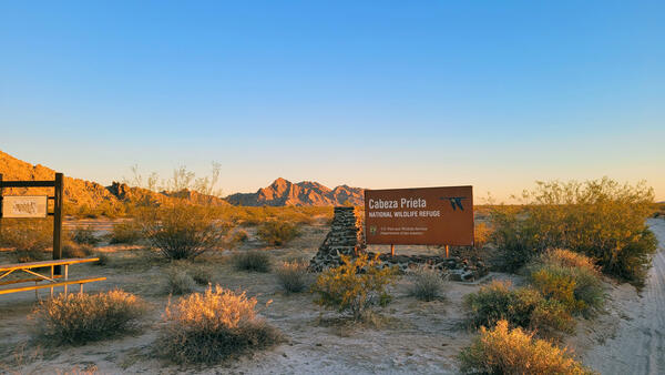
U.S. flag

An official website of the United States government

Images

Below are images associated with SBSC's science and staff. Images appear according to the year they were taken. To search, type a keyword or select a year from the dropdown menu. Or, click through the pages using the arrows at the bottom of the page. 

Filter Total Items: 665
Cathedral Valley, Capital Reef National Park, Utah

Cathedral Valley, Capital Reef National Park, Utah. Photo by Chris Benson, USGS.

Heavily grazed Colorado Plateau pinyon-juniper dryland habitat

Heavily grazed pinyon-juniper habitat on the Colorado Plateau. Photo by Shannon Lencioni, SBSC, USGS.

Clear glass bottles holding Colorado River for an incubation experiment
Incubation experiment with Colorado River water and sediment

Clear glass incubation bottles with Colorado River water and sediment for an experiment on phosphorus cycling

A woman with a USFWS shirt holds an eDNA sampler in Spencer Creek that flows into the Colorado River
A USFWS colleague samples eDNA in Spencer Creek that flows into the Colorado River

The USGS Southwest Biological Science Center (SBSC) is conducting environmental DNA (eDNA) research in and near the Colorado River in Grand Canyon to detect invasive fish species and other aquatic threats before they become established.

The USGS Southwest Biological Science Center (SBSC) is conducting environmental DNA (eDNA) research in and near the Colorado River in Grand Canyon to detect invasive fish species and other aquatic threats before they become established.

Bins of plants lines up outside a greenhouse
Greenhouse study comparing plant performance during drought.

Greenhouse study comparing plant performance during drought will help land managers choose plant species for restoring degraded lands. To find out more, follow the Restoration Assessment and Monitoring Program of the Southwest, housed at the Southwest Biolobigical Science Center. www.ugs.gov/sbsc/ramps

Greenhouse study comparing plant performance during drought will help land managers choose plant species for restoring degraded lands. To find out more, follow the Restoration Assessment and Monitoring Program of the Southwest, housed at the Southwest Biolobigical Science Center. www.ugs.gov/sbsc/ramps

On a research boat in the Grand Canyon, a man collects samples from the Colorado River using an eDNA sampler.
eDNA sampling in the Colorado River

A Bureau of Reclamation researcher, Kent Mosher, conducts eDNA sampling in the Colorado River to detect invasive aquatic species such as smallmouth bass.

A Bureau of Reclamation researcher, Kent Mosher, conducts eDNA sampling in the Colorado River to detect invasive aquatic species such as smallmouth bass.

Willows growing out of containers in a greenhouse for an experiment
Willows in a greenhouse experiment to determine how they respond to flows that cause inundation or drying along the Colorado River

Willows in a greenhouse experiment to determine how they respond to flows that cause inundation or drying along the Colorado River. Photo by Emily Palmquist, USGS Southwest Biological Science Center.

A woman stands in front of a table full of grasses in a greenhouse.
Drought experiments shed light on plant responses to climate change.

Greenhouse study comparing plant performance during drought will help land managers choose plant species for restoring degraded lands. To find out more, follow the Restoration Assessment and Monitoring Program of the Southwest, housed at the Southwest Biolobigical Science Center. www.ugs.gov/sbsc/ramps

Greenhouse study comparing plant performance during drought will help land managers choose plant species for restoring degraded lands. To find out more, follow the Restoration Assessment and Monitoring Program of the Southwest, housed at the Southwest Biolobigical Science Center. www.ugs.gov/sbsc/ramps

An illustration of a Myotis yuma bat drawn by Diana Valentin during a Northern Arizona University/USGS internship

An illustration of a Myotis yuma bat drawn by Diana Valentin during a Northern Arizona University/USGS internship. This illustration was drawn during a study that examined how the diversity and abundance of emerging aquatic insects affected bat abundance and foraging.

An illustration showing use of a bat echometer and a light trap to detect emerging aquatic insects

An illustration by Diana Valentin from Northern Arizona University shows the use of a bat echometer and a light trap to detect emerging aquatic insects, along the Colorado River in Grand Canyon.

An illustration of a Parastrellus hesperus canyon bat drawn by Diana Valentin during a NAU/USGS internship
An illustration of a Parastrellus hesperus canyon bat drawn by Diana Valentin during a Northern Arizona University/USGS internship

An illustration of a Parastrellus hesperus canyon bat drawn by Diana Valentin during a Northern Arizona University/USGS internship. This illustration was drawn during a study that examined how the diversity and abundance of emerging aquatic insects affected bat abundance and foraging.

An illustration showing use of a bat echometer and a light trap to detect emerging aquatic insects

An illustration by Diana Valentin from Northern Arizona University shows the use of a bat echometer and a light trap to detect emerging aquatic insects, along the Colorado River in Grand Canyon. This illustration was drawn during Diana Valentin's internship with USGS.

A scientist with the US Forest Service works with eDNA sampling equipment at Havasu Creek near the mouth of the Colorado Rive
A scientist works with eDNA aquatic sampling equipment at Havasu Creek near the mouth of the Colorado River

Thomas Franklin (depicted) is the eDNA Program Leader at the U.S. Forest Service, National Genomics Center for Wildlife and Fish Conservation. The USGS Southwest Biological Science Center's eDNA project is collaborating with the Bureau of Reclamation, U.S. Forest Service, U.S.

A close-up of a technician's hands holding an eDNA sample in a labeled biohazard plastic bag
An aquatic eDNA sample in a labeled biohazard plastic bag

A USGS technician holds an eDNA sample in a labeled biohazard plastic bag. Photo by Kim Dibble, USGS.

A man captures insects using a net.
Powerlines & Pollinators

Connecting powerline rights-of-way vegetation management to improve pollinator habitat. A USGS RAMPS technician samples pollinating insects along the Salt River Project powerline that crosses through Apache-Sitgreaves and Tonto National Forests.

Connecting powerline rights-of-way vegetation management to improve pollinator habitat. A USGS RAMPS technician samples pollinating insects along the Salt River Project powerline that crosses through Apache-Sitgreaves and Tonto National Forests.

A SBSC technician collects data on native plants for restoration, near Escalante, UT, May 2021
A SBSC technician collects data on native plants for restoration, near Escalante, UT

A SBSC technician, Shannon Lencioni, collects data on native plants for restoration, near Escalante, UT, in May 2021. Photo by Morgan Andrews, SBSC, USGS.

Three researchers walk through shrubs with rock formations and blue in the distance in Canyonlands National Park
USGS researchers walk to a vegetation and drought study site in Canyonlands National Park, Utah

USGS researchers walk to a long-term vegetation and drought study site in a Canyonlands National Park grassland, Utah, where long-term monitoring has occurred since 1998.

Was this page helpful?