U.S. flag

An official website of the United States government

Images

Below are images associated with SBSC's science and staff. Images appear according to the year they were taken. To search, type a keyword or select a year from the dropdown menu. Or, click through the pages using the arrows at the bottom of the page. 

Filter Total Items: 711
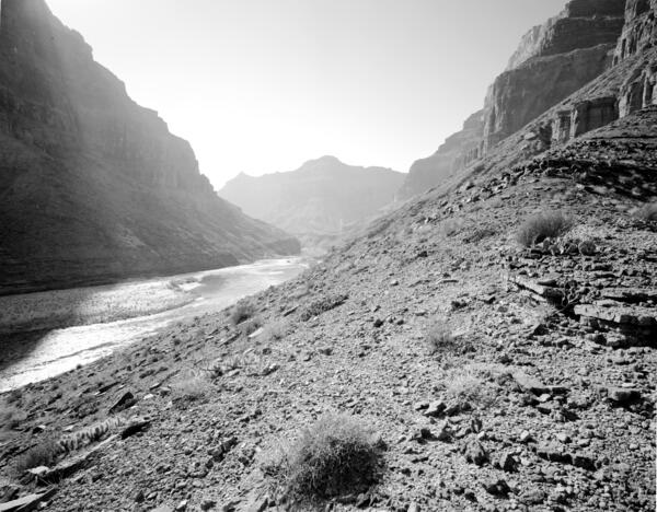
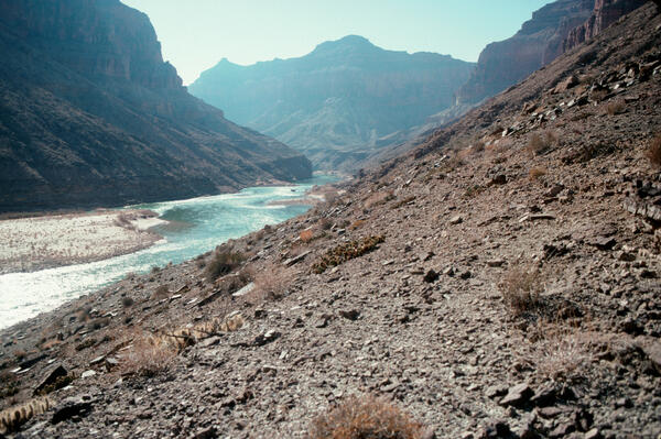
Colorado River, Grand Canyon, River Mile 65.5, Palisades Creek, Across Canyon View from River Left, 1991

February 6, 1991: Colorado River, Grand Canyon, River Mile 65.5, Palisades Creek, across canyon view from river left. Lava Canyon Rapid has changed considerably, owing to one or more debris flows over the past century from both sides of the river.
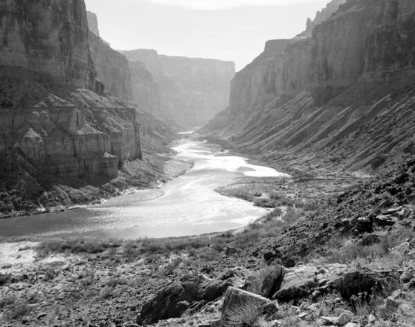
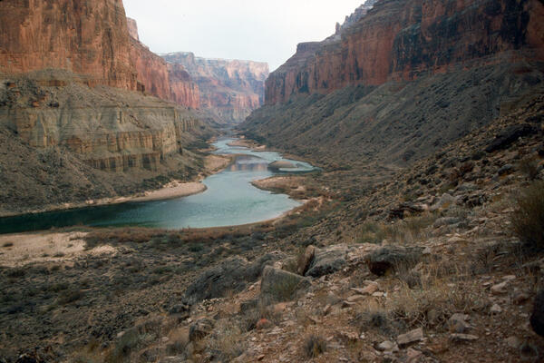
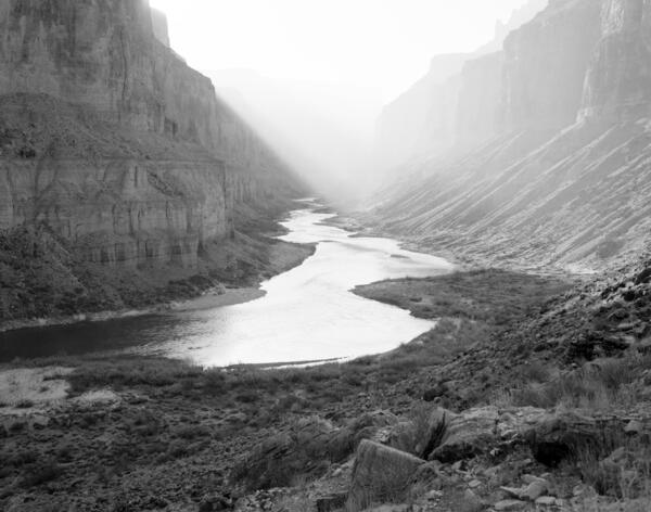
Colorado River, Grand Canyon, River Mile 52.8, Nankoweap, Downstream View from River Right, 1991

February 5, 1991: Colorado River, Grand Canyon, River Mile 52.8, Nankoweap, Downstream View from River Right. The river level is higher than it was in the original photograph, but the sand bars appear to have shifted and eroded; mesquite has increased, but not as much as the non-native tamarisk. Many of the Mormon tea plants visible in 1890 persist. Stake no.

February 5, 1991: Colorado River, Grand Canyon, River Mile 52.8, Nankoweap, Downstream View from River Right. The river level is higher than it was in the original photograph, but the sand bars appear to have shifted and eroded; mesquite has increased, but not as much as the non-native tamarisk. Many of the Mormon tea plants visible in 1890 persist. Stake no.

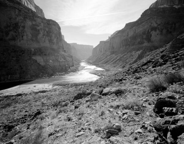
Colorado River, Grand Canyon, River Mile 52.8, Nankoweap, Downstream View from River Right, 1991

February 5, 1991. Colorado River, Grand Canyon, River Mile 52.8, Nankoweap, Downstream View from River Right. The river level is higher than it was 1890, and overall the amount of sand lining the river has declined or is now covered with riparian vegetation. Some of the sand bars appear to have shifted and aggraded.

February 5, 1991. Colorado River, Grand Canyon, River Mile 52.8, Nankoweap, Downstream View from River Right. The river level is higher than it was 1890, and overall the amount of sand lining the river has declined or is now covered with riparian vegetation. Some of the sand bars appear to have shifted and aggraded.

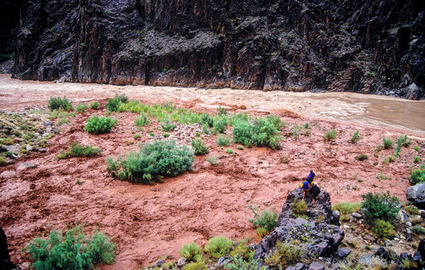
People standing on rocks overlooking the Colorado River during a large flash flood
A flash flood on the Colorado River at Monument Creek, Granite Rapid, Grand Canyon

A flash flood on the Colorado River in Grand Canyon, at the Monument Creek debris fan, at Granite Rapid. River rafters, parked far enough upstream to be safe from the flash flood, observe from a high rock and scout potential changes to Granite Rapid. Photo by Jeff Behan. 

A flash flood on the Colorado River in Grand Canyon, at the Monument Creek debris fan, at Granite Rapid. River rafters, parked far enough upstream to be safe from the flash flood, observe from a high rock and scout potential changes to Granite Rapid. Photo by Jeff Behan. 

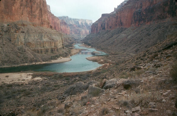
Colorado River, Grand Canyon, River Mile 65.5, Palisades Creek, Across Canyon View from River Left, 1990

January 24, 1990: Colorado River, Grand Canyon, River Mile 65.5, Palisades Creek, across canyon view from River left. Stake no. s1434 in the Southwest Repeat Photography Collection. Photo by Glenn Rink.

Colorado River, Grand Canyon, River Mile 65.5, Palisades Creek, Across Canyon View from River Left, 1990

Colorado River, Grand Canyon, River Mile 65.5, Palisades Creek, Across Canyon View from River Left. Stake no. s1434 in the Southwest Repeat Photography Collection. Photo by Glenn Rink.

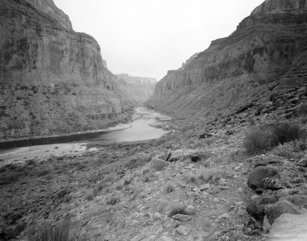
Colorado River, Grand Canyon, River Mile 52.8, Nankoweap, Downstream View from River Right, 1990

January 23, 1990: Colorado River, Grand Canyon, River Mile 52.8, Nankoweap, Downstream View from River Right. Stake no. 1424b in the Southwest Repeat Photography Collection. Photo by Robert H. Webb.

Colorado River, Grand Canyon, River Mile 61.4, Little Colorado River, Downstream View from River Right, 1990

January 23, 1990: Colorado River, Grand Canyon, River Mile 61.4, Little Colorado River, Downstream View from River Right. A century later, many of the same plants are still visible, with some mortality and recruitment of the Mormon tea, catclaw, and pricklypear.

Colorado River, Grand Canyon, River Mile 61.4, Little Colorado River, Downstream View from River Right, 1990

 January 23, 1990: Colorado River, Grand Canyon, River Mile 61.4, Little Colorado River, Downstream View from River Right. A century later, many of the same plants are still visible, with some mortality and recruitment of the Mormon tea, catclaw, and prickly pear.

Colorado River, Grand Canyon, River Mile 52.8, Nankoweap, Downstream View from River Right, 1990

January 23, 1990: Colorado River, Grand Canyon, River Mile 52.8, Nankoweap, Downstream View from River Right. Stake no. s1424b in the Southwest Repeat Photography Collection. Photo by Robert H. Webb.

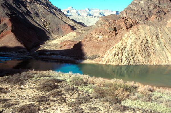
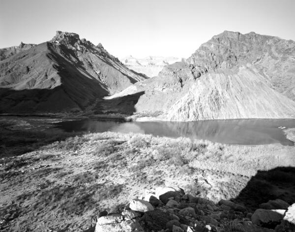
Colorado River Mile 52.8, Nankoweap, Downstream View from River Right, 1990
Colorado River, Grand Canyon, River Mile 52.8, Nankoweap, Downstream View from River Right, 1990

January 22, 1990. Colorado River, Grand Canyon, River Mile 52.8, Nankoweap, Downstream View from River Right. Stake no. s1424a in the Southwest Repeat Photography Collection. Photo by Robert H. Webb, USGS. 

Colorado River, Grand Canyon, River Mile 52.8, Nankoweap, Downstream View from River Right, 1990

January 22, 1990. Colorado River, Grand Canyon, River Mile 52.8, Nankoweap, Downstream View from River Right. Stake no. s1424a in the Southwest Repeat Photography Collection. Photo by Robert H. Webb, USGS.

Repeat photograph of a beach along the Colorado River taken in 1983 that is a match to an EC LaRue USGS 1923 Birdseye Expedit
Repeat photograph of a beach along the Colorado River taken in 1983 that is a match to an EC LaRue USGS 1923 Birdseye Expedition image

A USGS repeat photograph that is a match to an E.C. LaRue USGS image from 1923, taken during the Birdseye Expedition, prior to Glen Canyon Dam. Note the increase in vegetation in this image. The 1923 image was taken along the Colorado River, at River Mile 197, from the left bank, and repeat images were taken by the USGS in 1972, 1983, 1994, and 2016.

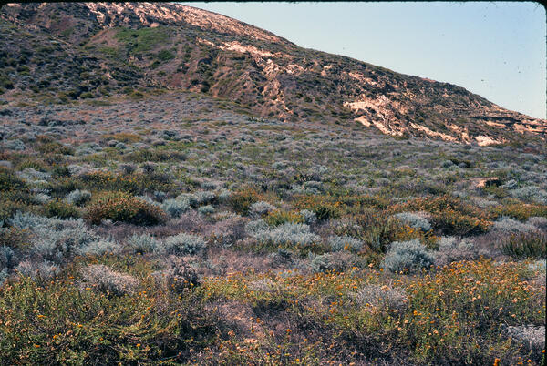
A hillside filled with shrubs and stands of yellow flowers on San Nicolas Island, one of the Channel Islands in CA
Island Night Lizard habitat on San Nicolas Island, CA

Flowering shrubs and other native plants on a hillside on San Nicolas Island, one of the Channel Islands off the coast of California. This area is Island Night Lizard habitat. Photo by Charles Drost, Sept 1983.

Flowering shrubs and other native plants on a hillside on San Nicolas Island, one of the Channel Islands off the coast of California. This area is Island Night Lizard habitat. Photo by Charles Drost, Sept 1983.

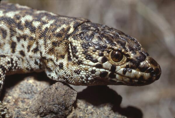
Close-up view of an island night lizard’s upper body highlighting its textured scales and mottled black‑and‑brown coloration.
Island Night Lizard on San Nicolas Island

An Island Night Lizard (Xantusia riversiana) on San Nicolas Island. Photo by Charles Drost, USGS.

Repeat photograph of a beach along the Colorado River taken in 1972 that is a match to an EC LaRue USGS 1923 image
Repeat photograph of a beach along the Colorado River taken in 1972 that is a match to an EC LaRue USGS 1923 Birdseye Expedition image

A USGS repeat photograph that is a match to an E.C. LaRue USGS image from 1923, taken during the Birdseye Expedition, prior to Glen Canyon Dam. Note the increase in vegetation in this image. The 1923 image was taken along the Colorado River, at River Mile 197, from the left bank, and repeat images were taken by the USGS in 1972, 1983, 1994, and 2016.

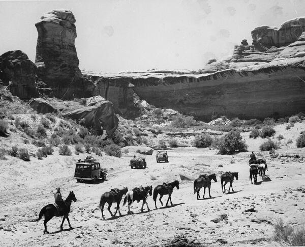
Historic photograph of a group of cars and people on horses in 1965 in Canyonlands National Park
Historic photograph a group of packhorses and vehicles in Canyonlands National Park, 1965

This historic photograph shows a group of packhorses and several vehicles moving upstream on Salt Creek just upstream from Peekaboo Arch. Taken at the time that Canyonlands was established as a national park, it shows a wide channel with flanking narrow, high floodplains and colluvial terraces resulting from rockfall and eolian distribution under the bedrock walls.

This historic photograph shows a group of packhorses and several vehicles moving upstream on Salt Creek just upstream from Peekaboo Arch. Taken at the time that Canyonlands was established as a national park, it shows a wide channel with flanking narrow, high floodplains and colluvial terraces resulting from rockfall and eolian distribution under the bedrock walls.

San Pedro River valley, near St. David, AZ - 1962. Photo by J.R. Hastings
Repeat photograph of the San Pedro River valley, near St. David, AZ

Repeat photography of the San Pedro River valley, near St. David, AZ. This photo, taken by J.R. Hastings in 1962, is a repeat of the 1891 image taken by Roskruge in SBSC's Southwest Repeat Photography Collection. Stake (camera point) s0151.

Repeat photography of the San Pedro River valley, near St. David, AZ. This photo, taken by J.R. Hastings in 1962, is a repeat of the 1891 image taken by Roskruge in SBSC's Southwest Repeat Photography Collection. Stake (camera point) s0151.

A historic black and white photo of a stream gage above Moenkopi Wash, near Cameron, AZ
Moenkopi Wash stream gage near Cameron, AZ, in 1959

A historic image taken in 1959 of Moenkopi Wash near Cameron, Arizona, stream gage #09401500. USGS photo. A repeat photograph of this location was taken in 2022, and can be seen here: https://www.usgs.gov/media/images/moenkopi-wash-stream-gage-near-cameron-az-2022

A man stands on a bridge over Moenkopi Wash, AZ, near Tuba City, in a historic black and white photo taken in 1941
A bridge over Moenkopi Wash near Tuba City, AZ, in 1941

A man stands on a bridge over Moenkopi Wash, near Tuba City, AZ, stream gage # 09401400 in a historic black and white photo taken in 1941. USGS photo.

A man stands on a bridge over Moenkopi Wash, near Tuba City, AZ, stream gage # 09401400 in a historic black and white photo taken in 1941. USGS photo.

A historic black and white photo of a stream gage taken in 1941 looking upstream at Moenkopi Wash, near Tuba City, AZ
Moenkopi Wash, looking upstream, near Tuba City, AZ, in 1941

A historic image taken in 1941 from a bridge looking upstream at Moenkopi Wash near Tuba City, Arizona, stream gage # 09401400. USGS photo.

Was this page helpful?