



Sandbars in Grand Canyon are influenced by the amount of sand avaiable to build sandbars and the flow of the river, both of which are affected by Glen Canyon Dam.
Images
Below are images associated with SBSC's science and staff. Images appear according to the year they were taken. To search, type a keyword or select a year from the dropdown menu. Or, click through the pages using the arrows at the bottom of the page.
Filter Total Items: 711

Sandbar in the Colorado River in Grand Canyon
Sandbars in Grand Canyon are influenced by the amount of sand avaiable to build sandbars and the flow of the river, both of which are affected by Glen Canyon Dam.

View of sandbar on Colorado River at River Mile 65
View of sandbar on Colorado River at River Mile 65View of reattachment sandbar located near the Carbon Creek drainage on Colorado River (River Mile 65). Photo is from the long-term sandbar monitoring remote camera time-series archives, and shows the sandbar two months after the 2008 Spring High Flow Event.
View of sandbar on Colorado River at River Mile 65
View of sandbar on Colorado River at River Mile 65View of reattachment sandbar located near the Carbon Creek drainage on Colorado River (River Mile 65). Photo is from the long-term sandbar monitoring remote camera time-series archives, and shows the sandbar two months after the 2008 Spring High Flow Event.
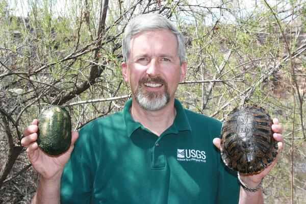
Dr. Jeff Lovich holding a native and non-native turtle in each hand near Montezuma Well, AZ
Dr. Jeff Lovich holding a native and non-native turtle in each hand near Montezuma Well, AZDr. Jeff Lovich holding a native and non-native turtle in each hand near Montezuma Well, AZ, April 2008. The small turtle is a native Sonora mud turtle (Kinosternon sonoriense) and the larger turtle is a non-native Red-eared slider (Trachemys scripta elegans). The red-eared sliders have been removed from Montezuma Well.
Dr. Jeff Lovich holding a native and non-native turtle in each hand near Montezuma Well, AZ
Dr. Jeff Lovich holding a native and non-native turtle in each hand near Montezuma Well, AZDr. Jeff Lovich holding a native and non-native turtle in each hand near Montezuma Well, AZ, April 2008. The small turtle is a native Sonora mud turtle (Kinosternon sonoriense) and the larger turtle is a non-native Red-eared slider (Trachemys scripta elegans). The red-eared sliders have been removed from Montezuma Well.
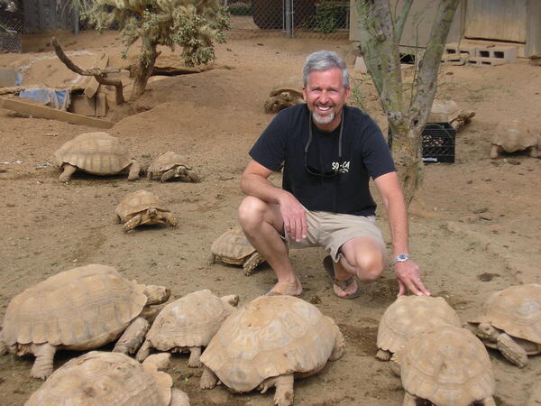
Dr. Jeff Lovich and spur-thighed tortoises
Dr. Jeff Lovich kneels near spur-thighed tortoises at a rescue in Phoenix, AZ. Spur-thighed tortoises, also called Greek tortoises, are native to northern Africa through central Asia.
Dr. Jeff Lovich kneels near spur-thighed tortoises at a rescue in Phoenix, AZ. Spur-thighed tortoises, also called Greek tortoises, are native to northern Africa through central Asia.
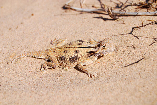
A flat-tailed horned lizard
The flat-tailed horned lizard (Phrynosoma mcallii) lives in low, level, desert areas of Arizona, California, and Mexico that are suitable for solar energy development. Photo by Robert Lovich.
The flat-tailed horned lizard (Phrynosoma mcallii) lives in low, level, desert areas of Arizona, California, and Mexico that are suitable for solar energy development. Photo by Robert Lovich.

A Sonora Mud Turtle (Kinosternon sonoriense) hatchling, Montezuma Well, next to a quarter for a similar size comparison
A Sonora Mud Turtle (Kinosternon sonoriense) hatchling, Montezuma Well, next to a quarter for a similar size comparisonA Sonora Mud Turtle (Kinosternon sonoriense) hatchling, Montezuma Well, with a quarter for a size comparison. Kinosternon sonoriense are found only in aquatic habitats in the southwestern United States and northwestern Mexico. They are listed on the IUCN Red List and some subspecies are listed as critically imperiled. Photo by Charles Drost, USGS, SBSC.
A Sonora Mud Turtle (Kinosternon sonoriense) hatchling, Montezuma Well, next to a quarter for a similar size comparison
A Sonora Mud Turtle (Kinosternon sonoriense) hatchling, Montezuma Well, next to a quarter for a similar size comparisonA Sonora Mud Turtle (Kinosternon sonoriense) hatchling, Montezuma Well, with a quarter for a size comparison. Kinosternon sonoriense are found only in aquatic habitats in the southwestern United States and northwestern Mexico. They are listed on the IUCN Red List and some subspecies are listed as critically imperiled. Photo by Charles Drost, USGS, SBSC.
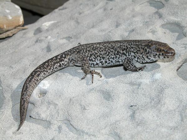
Island Night Lizard on San Nicolas Island - Larger Image
Island Night Lizard on San Nicolas Island - Larger ImageIsland night lizard on San Nicolas Island (May 2007).
Island Night Lizard on San Nicolas Island - Larger Image
Island Night Lizard on San Nicolas Island - Larger ImageIsland night lizard on San Nicolas Island (May 2007).

Drilling for mineral resources near Canyonlands National Park, Utah
Drilling for mineral resources near Canyonlands National Park, UtahDrilling for mineral resources near Canyonlands National Park, Utah
Drilling for mineral resources near Canyonlands National Park, Utah
Drilling for mineral resources near Canyonlands National Park, UtahDrilling for mineral resources near Canyonlands National Park, Utah

Tamarisk plants can make many flowers
Tamarisk plants have been sucessful in southwestern US river- and stream-side habitats, in part because of its ablity to make many flowers and, therefore, seeds.
Tamarisk plants have been sucessful in southwestern US river- and stream-side habitats, in part because of its ablity to make many flowers and, therefore, seeds.

Nonnative tamarisk re-sprouts after wildfire
Nonnative tamarisk is resistant to wildfire, in part due to its ability to resprout
Nonnative tamarisk is resistant to wildfire, in part due to its ability to resprout

A single species stand of nonnative tamarisk
Single species stand of nonnative tamarisk on the Lower Colorado River at Cibola National Wildlife Refuge, California
Single species stand of nonnative tamarisk on the Lower Colorado River at Cibola National Wildlife Refuge, California

Nonnative tamarisk re-grows following a wildfire
Nonnative tamarisk is resistant to wildfire, in part because of its ablity to re-sprout.
Nonnative tamarisk is resistant to wildfire, in part because of its ablity to re-sprout.
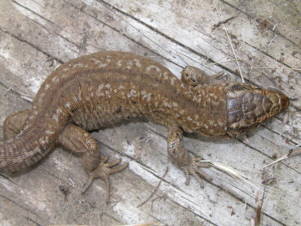
A tan colored Island Night Lizard, San Nicolas Island
A tan colored Island Night Lizard, San Nicolas IslandA tan colored Island Night Lizard on San Nicolas Island. Photo by Charles Drost, USGS.
A tan colored Island Night Lizard, San Nicolas Island
A tan colored Island Night Lizard, San Nicolas IslandA tan colored Island Night Lizard on San Nicolas Island. Photo by Charles Drost, USGS.
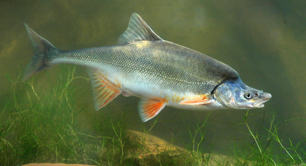
A humpback chub swims in the Colorado River
A humpback chub swims in the Colorado River. Photo by George Andrejko, AZ Game and Fish Department. Public domain.
A humpback chub swims in the Colorado River. Photo by George Andrejko, AZ Game and Fish Department. Public domain.

Humpback Chub specimen in tank
A lab photo of Humpback Chub specimen in tank
A lab photo of Humpback Chub specimen in tank

Repeat photograph of Tsegi Canyon, Laguna Creek, northern Arizona, 2005
Repeat photograph of Tsegi Canyon, Laguna Creek, northern Arizona, 2005Repeat photograph of Tsegi Canyon, Laguna Creek, northern Arizona, north of Rt. 160, taken by Dr. Robert Webb, USGS, in 2005. The original photograph in this series was taken in 1927 J.J. Hanks. The series is from the SBSC's Southwest Repeat Photography Collection, stake (camera point) s4821.
Repeat photograph of Tsegi Canyon, Laguna Creek, northern Arizona, 2005
Repeat photograph of Tsegi Canyon, Laguna Creek, northern Arizona, 2005Repeat photograph of Tsegi Canyon, Laguna Creek, northern Arizona, north of Rt. 160, taken by Dr. Robert Webb, USGS, in 2005. The original photograph in this series was taken in 1927 J.J. Hanks. The series is from the SBSC's Southwest Repeat Photography Collection, stake (camera point) s4821.

Repeat photograph of Tsegi Canyon, Laguna Creek, northern Arizona, 2005
Repeat photograph of Tsegi Canyon, Laguna Creek, northern Arizona, 2005Repeat photograph of Tsegi Canyon, Laguna Creek, northern Arizona, north of Rt. 160, taken by Dr. Robert Webb, USGS, in 2005. The original photograph in this series was taken in 1927 J.J. Hanks. This photo is a repeat photographic match taken in color to a B/W photo, both in 2005.
Repeat photograph of Tsegi Canyon, Laguna Creek, northern Arizona, 2005
Repeat photograph of Tsegi Canyon, Laguna Creek, northern Arizona, 2005Repeat photograph of Tsegi Canyon, Laguna Creek, northern Arizona, north of Rt. 160, taken by Dr. Robert Webb, USGS, in 2005. The original photograph in this series was taken in 1927 J.J. Hanks. This photo is a repeat photographic match taken in color to a B/W photo, both in 2005.

Van Dorn water sampler, Lake Powell
A discrete water sample is collected from one of Lake Powell's Reservoir's main inflows. The Van Dorn water sampler pictured here is lowered to the desired depth and then triggered to close using a small metal weight. Photo by SBSC, 2005.
A discrete water sample is collected from one of Lake Powell's Reservoir's main inflows. The Van Dorn water sampler pictured here is lowered to the desired depth and then triggered to close using a small metal weight. Photo by SBSC, 2005.
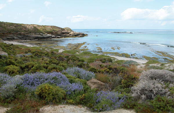
San Nicolas Island coastline with flowering shrubs
San Nicolas Island coastline with flowering shrubsSan Nicolas Island coastline with a calm sea and flowering shrubs. San Nicolas Island is one of the Channel Islands off the coast of southern California. The endemic Island Night Lizard is found only on the Channel Islands.
San Nicolas Island coastline with flowering shrubs
San Nicolas Island coastline with flowering shrubsSan Nicolas Island coastline with a calm sea and flowering shrubs. San Nicolas Island is one of the Channel Islands off the coast of southern California. The endemic Island Night Lizard is found only on the Channel Islands.

Biocrusts in Canyonlands National Park
Intact biological soil crusts (biocrusts) in Canyonlands National Park. Photo taken by Jayne Belnap, USGS, 2004.
Intact biological soil crusts (biocrusts) in Canyonlands National Park. Photo taken by Jayne Belnap, USGS, 2004.

View of Colorado River confluence with the Little Colorado River
View of Colorado River confluence with the Little Colorado RiverView of Colorado River confluence with the Little Colorado River taken from the rim of Marble Canyon
View of Colorado River confluence with the Little Colorado River
View of Colorado River confluence with the Little Colorado RiverView of Colorado River confluence with the Little Colorado River taken from the rim of Marble Canyon