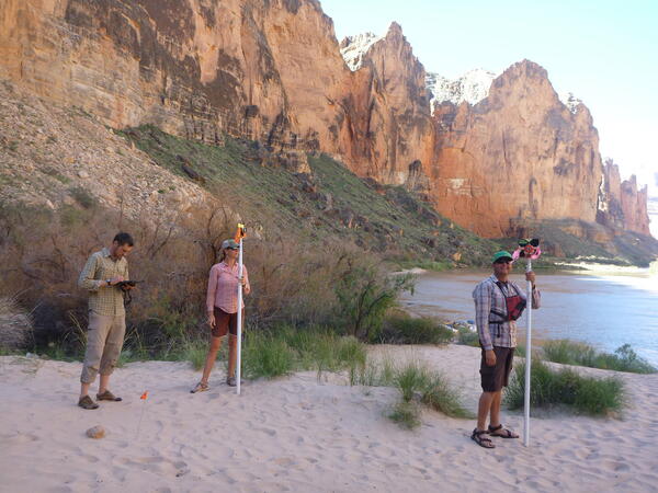
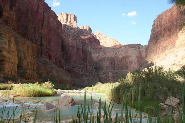
U.S. flag

An official website of the United States government

Images

Below are images associated with SBSC's science and staff. Images appear according to the year they were taken. To search, type a keyword or select a year from the dropdown menu. Or, click through the pages using the arrows at the bottom of the page. 

Filter Total Items: 641
Image: A Rainbow Trout Rests Among Cobble Substrate in Panther Creek
A Rainbow Trout Rests Among Cobble Substrate in Panther Creek

A rainbow trout rests among cobble substrate in Panther Creek downstream of Big Deer Creek, central Idaho. Panther Creek was severely damaged by heavy metals released from mining and milling activities at the former Blackbird Mine, and water quality in this section of the stream was acutely lethal to fish as late as 1985.

A rainbow trout rests among cobble substrate in Panther Creek downstream of Big Deer Creek, central Idaho. Panther Creek was severely damaged by heavy metals released from mining and milling activities at the former Blackbird Mine, and water quality in this section of the stream was acutely lethal to fish as late as 1985.

Bighorn sheep emerging from a tinaja water catchment in Cabeza Prieta National Wildlife Refuge, AZ

Bighorn sheep emerging from the Eagle Tank water catchment, called a tinaja, in Cabeza Prieta National Wildlife Refuge (CPNWR), southern AZ. Photo courtesy of US Fish and Wildlife Service, CPNWR.

A bighorn sheep stands on the edge of a tinaja water catchment, Cabeza Prieta National Wildlife Refuge, AZ

A bighorn sheep stands on the edge of the Senita Tank water catchment, also called a tinaja, in Cabeza Prieta National Wildlife Refuge (CPNWR), southern AZ. Photo courtesy of US Fish and Wildlife Service, CPNWR.

A bighorn sheep stands on the edge of a tinaja water catchment in Cabeza Prieta National Wildlife Refuge, AZ

A bighorn sheep stands on the edge of the Senita Tank water catchment, called a tinaja, in Cabeza Prieta National Wildlife Refuge (CPNWR), southern AZ. Photo courtesy of US Fish and Wildlife Service, CPNWR.

A bighorn sheep stands by a tinaja water catchment, Cabeza Prieta National Wildlife Refuge, AZ

A bighorn sheep stands by the Senita Tank water catchment, also called a tinaja, in Cabeza Prieta National Wildlife Refuge (CPNWR), southern AZ. Photo courtesy of the US Fish and Wildlife Service, CPNWR.

Western yellow-billed cuckoo in riparian habitat, southern Arizona

A western yellow-billed cuckoo in a cottonwood tree in riparian habitat that many people in the western U.S. associate with the species, near Patagonia, southern Arizona, 2011. Photo by Alan Schmierer, used with permission and public domain.

A western yellow-billed cuckoo in a cottonwood tree in riparian habitat that many people in the western U.S. associate with the species, near Patagonia, southern Arizona, 2011. Photo by Alan Schmierer, used with permission and public domain.

Two bighorn sheep butt heads next to a tinaja water catchment, Cabeza Prieta National Wildlife Refuge, AZ

Two bighorn sheep butt heads next to the Eagle Tank water catchment, called a tinaja, at Cabeza Prieta National Wildlife Refuge, southern AZ. Photo courtesy of the US Fish and Wildlife Service, CPNWR.

A bighorn sheep emerges from a tinaja water catchment, Cabeza Prieta National Wildlife Refuge, AZ

A bighorn sheep emerges from the Buck Tank water catchment, called a tinaja, at Cabeza Prieta National Wildlife Refuge (CPNWR), southern AZ. Photo courtesy of the US Fish and Wildlife Service, CPNWR.

Same sandbar in 2008 and in 2011 in Colorado River
Same sandbar in 2008 and in 2011 in the Colorado River, Grand Canyon

Photograph of sandbar about 45 miles downstream from Lees Ferry, Arizona showing river party camping on large sandbar deposited by the 2008 high-flow experiment (left) and again in August 2011 (right) when the size of the sandbar and campsite was much smaller. USGS photos, public domain.

Photograph of sandbar about 45 miles downstream from Lees Ferry, Arizona showing river party camping on large sandbar deposited by the 2008 high-flow experiment (left) and again in August 2011 (right) when the size of the sandbar and campsite was much smaller. USGS photos, public domain.

Technicians installing remote PIT tags at the Little Colorado River
Technicians at the Little Colorado River

Technicians setting up to install remote PIT tags at the Little Colorado River. USGS photo.

Two bighorn sheep emerge from a tinaja water catchment in southern AZ Cabeza Prieta National Wildlife Refuge
Two bighorn sheep emerge from a tinaja water catchment in Cabeza Prieta National Wildlife Refuge, AZ

Two bighorn sheep emerge from Buck Tank water catchment, called a tinaja, in Cabeza Prieta National Wildlife Refuge (CPNWR), southern Arizona. Photo courtesy of the US Fish and Wildlife Service, CPNWR.

Repeat photograph taken in 2011 of the Colorado River below Glen Canyon Dam
Repeat photograph taken in 2011 of the Colorado River below Glen Canyon Dam, a match to the 1889 Stanton Expedition & 1992 USGS images

A USGS repeat photograph of Glen Canyon Dam taken on April 20, 2011, as a match to the 1889 Franklin Nims image of the site before the dam was built, at Colorado River mile -14.7, during the Stanton Expedition. This view was also matched in 1992 by the USGS. The view is taken looking downstream below the dam, from river left.

Repeat color photograph taken in 2011 of Glen Canyon Dam, a match to the 1889 Stanton Expedition & 1992 USGS images

A USGS repeat photograph of Glen Canyon Dam taken on April 20, 2011 as a match to the 1889 Franklin Nims image of the site before the dam was built, at Colorado River mile -14.7, during the Stanton Expedition. This view was also matched in 1992 by the USGS. The view is taken upstream from river left.

Saguaro cacti on rocky slope in the Sonoran Desert, AZ
Saguaro cacti on a rocky slope in the Sonoran Desert, AZ

Steep, rocky slopes in Saguaro National Park near Tucson, AZ provide habitat for saguaros and may buffer populations from the negative effects of drought. Photo courtesy of Daniel Winkler, USGS SBSC.

Steep, rocky slopes in Saguaro National Park near Tucson, AZ provide habitat for saguaros and may buffer populations from the negative effects of drought. Photo courtesy of Daniel Winkler, USGS SBSC.

Repeat photograph of Saguaro National Monument East, Rincon Mountain District, 2010. Photo by Ray Turner, USGS
Repeat photograph of Saguaro National Monument East, Rincon Mountain District, 2010 (black and white version)

Repeat photograph of Saguaro National Monument (now Saguaro National Park) East, Rincon Mountain District. This photo was taken in 2010 by Dr. Ray Turner, USGS and is a match of a 1935 photograph taken by the National Park Service (NPS).

A National Park Service employee holds a brown trout in Grand Canyon

USFWS and USGS partner on brown trout research in Grand Canyon's Colorado River. This trout was removed from Bright Angel Creek, a tributary of the Colorado River. Photo courtesy of Brian Healy, formerly with National Park Service, Grand Canyon National Park, and now with USGS.

USFWS and USGS partner on brown trout research in Grand Canyon's Colorado River. This trout was removed from Bright Angel Creek, a tributary of the Colorado River. Photo courtesy of Brian Healy, formerly with National Park Service, Grand Canyon National Park, and now with USGS.

A captured brown trout held in-hand that has several smaller fish tails protruding from its mouth
A brown trout that has partially eaten several smaller fish

A captured brown trout has partially eaten several smaller fish and has tails protruding from its mouth. Photo courtesy of Brian Healy, formerly with National Park Service, Grand Canyon National Park, and now with USGS.

A captured brown trout has partially eaten several smaller fish and has tails protruding from its mouth. Photo courtesy of Brian Healy, formerly with National Park Service, Grand Canyon National Park, and now with USGS.

People electrofishing in a tributary in Grand Canyon to remove nonnative fish
Electrofishing in a tributary in Grand Canyon

Electrofishing in a tributary in Grand Canyon to remove non-native fish. Photo courtesy of Brian Healy, formerly with National Park Service, Grand Canyon National Park, and now with USGS.

Electrofishing in a tributary in Grand Canyon to remove non-native fish. Photo courtesy of Brian Healy, formerly with National Park Service, Grand Canyon National Park, and now with USGS.

A view of the Colorado River, Phantom Ranch and Bright Angel Creek in Grand Canyon National Park

A landscape view of the Colorado River, Phantom Ranch, Bright Angel Bridge, and Bright Angel Creek in Grand Canyon National Park. Photo courtesy of Brian Healy, formerly with National Park Service, Grand Canyon National Park, and now with USGS.

Was this page helpful?