
Aerial view of the study area in Canyonlands National Park.
Images
Below are images associated with SBSC's science and staff. Images appear according to the year they were taken. To search, type a keyword or select a year from the dropdown menu. Or, click through the pages using the arrows at the bottom of the page.
Filter Total Items: 703

Canyonlands National Park
Aerial view of the study area in Canyonlands National Park.

Repeat photograph of Saguaro National Monument East, Rincon Mountain District, 2010 (color)
Repeat photograph of Saguaro National Monument East, Rincon Mountain District, 2010 (color)Repeat photograph of Saguaro National Monument (now Saguaro National Park) East, Rincon Mountain District. This photo was taken in 2010 by Dr. Ray Turner, USGS and is a match of a 1935 photograph taken by the National Park Service (NPS).
Repeat photograph of Saguaro National Monument East, Rincon Mountain District, 2010 (color version)
Repeat photograph of Saguaro National Monument East, Rincon Mountain District, 2010 (color version)Repeat photograph of Saguaro National Monument (now Saguaro National Park) East, Rincon Mountain District. This photo was taken in 2010 by Dr. Ray Turner, USGS and is a match of a 1935 photograph taken by the National Park Service (NPS).

Saguaro National Park, East Unit, Southern Arizona - 2010
Saguaro National Park, East Unit, Southern Arizona - 2010Saguaro National Monument is now Saguaro National Park. The decline is saguaros has continued but at a rate slightly less steep than predicted. Very few of the saguaro present in 1935 remain. Meanwhile, the regeneration of this forest has already begun, as shown by findings from a long-term study-plot located at left midground.

A Yucca moth is depositing a pollen ball onto a stigma of a Yucca plant
A Yucca moth is depositing a pollen ball onto a stigma of a Yucca plantA Tegeticula maculata Yucca moth is perched & depositing a pollen ball onto a stigma of a Yucca plant (Hesperoyucca whipplei). Photo by Sherwin Carlquist, 2010.

Beach on the Colorado River in Grand Canyon
Beaches in the rough terrain of Grand Canyon are a valued resource by hikers and river runners because they are fairly flat and vegetation free.
Beaches in the rough terrain of Grand Canyon are a valued resource by hikers and river runners because they are fairly flat and vegetation free.
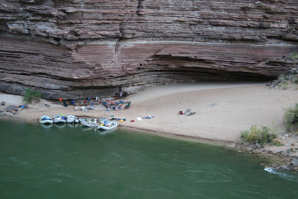
Large campsite area on the Colorado River in Grand Canyon
Large campsite area on the Colorado River in Grand CanyonBoats at a large campsite area along the Colorado River in Grand Canyon, 2009. USGS photo, public domain.
Large campsite area on the Colorado River in Grand Canyon
Large campsite area on the Colorado River in Grand CanyonBoats at a large campsite area along the Colorado River in Grand Canyon, 2009. USGS photo, public domain.
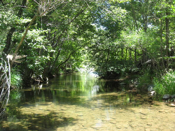
Riparian vegetation along West Clear Creek in Arizona
Riparian vegetation along West Clear Creek in ArizonaRiparian vegetation along West Clear Creek in Arizona. Photo by Chris Calvo, National Park Service.
Riparian vegetation along West Clear Creek in Arizona
Riparian vegetation along West Clear Creek in ArizonaRiparian vegetation along West Clear Creek in Arizona. Photo by Chris Calvo, National Park Service.

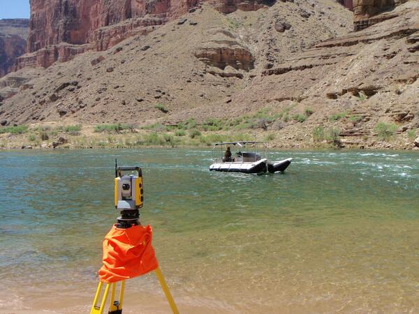
Boat equipped with multibeam sonar
Boat equipped with multibeam sonar surveying the bed of the Colorado River in May 2009. Instrument in foreground is robotic total station that automatically tracks boat location and radios the position to a computer on the boat 20 times per second.
Boat equipped with multibeam sonar surveying the bed of the Colorado River in May 2009. Instrument in foreground is robotic total station that automatically tracks boat location and radios the position to a computer on the boat 20 times per second.
Boat in Colorado River using multibeam sonar to survey river bed
Boat in Colorado River using multibeam sonar to survey river bedBoat equipped with multibeam sonar surveying the bed of the Colorado River in May 2009. Instrument in foreground is robotic total station that automatically tracks boat location and radios the position to a computer on the boat 20 times per second.
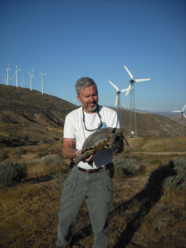
Jeff Lovich with desert tortoise
U.S. Geological Survey Research Ecologist Jeff Lovich holding a radioed desert tortoise at the Mesa wind farm near Palm Springs, California.
U.S. Geological Survey Research Ecologist Jeff Lovich holding a radioed desert tortoise at the Mesa wind farm near Palm Springs, California.

Rio Grande in Big Bend National Park repeat photography from about 1945 and 2008 showing channel narrowing
Rio Grande in Big Bend National Park repeat photography from about 1945 and 2008 showing channel narrowingRepeat photography from about 1945 (top panel) and 2008 (bottom panel) showing channel narrowing over time in a portion of the Rio Grande in Big Bend National Park.

The Needles District, Canyonlands National Park
The Needles District, Canyonlands National Park
The Needles District, Canyonlands National Park

Sandbar in the Colorado River in Grand Canyon
Sandbars in Grand Canyon are influenced by the amount of sand avaiable to build sandbars and the flow of the river, both of which are affected by Glen Canyon Dam.
Sandbars in Grand Canyon are influenced by the amount of sand avaiable to build sandbars and the flow of the river, both of which are affected by Glen Canyon Dam.

View of sandbar on Colorado River at River Mile 65
View of sandbar on Colorado River at River Mile 65View of reattachment sandbar located near the Carbon Creek drainage on Colorado River (River Mile 65). Photo is from the long-term sandbar monitoring remote camera time-series archives, and shows the sandbar two months after the 2008 Spring High Flow Event.
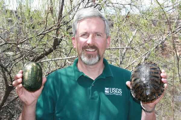
Dr. Jeff Lovich holding a native and non-native turtle in each hand near Montezuma Well, AZ
Dr. Jeff Lovich holding a native and non-native turtle in each hand near Montezuma Well, AZDr. Jeff Lovich holding a native and non-native turtle in each hand near Montezuma Well, AZ, April 2008. The small turtle is a native Sonora mud turtle (Kinosternon sonoriense) and the larger turtle is a non-native Red-eared slider (Trachemys scripta elegans). The red-eared sliders have been removed from Montezuma Well.
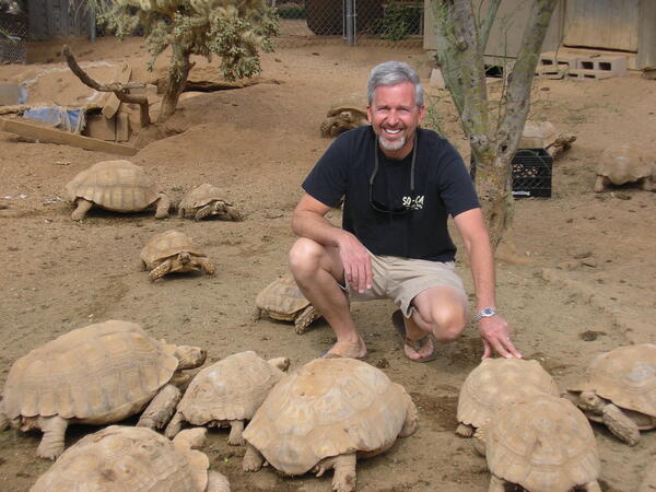
Dr. Jeff Lovich and spur-thighed tortoises
Dr. Jeff Lovich kneels near spur-thighed tortoises at a rescue in Phoenix, AZ. Spur-thighed tortoises, also called Greek tortoises, are native to northern Africa through central Asia.
Dr. Jeff Lovich kneels near spur-thighed tortoises at a rescue in Phoenix, AZ. Spur-thighed tortoises, also called Greek tortoises, are native to northern Africa through central Asia.
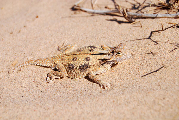
A flat-tailed horned lizard
The flat-tailed horned lizard (Phrynosoma mcallii) lives in low, level, desert areas of Arizona, California, and Mexico that are suitable for solar energy development. Photo by Robert Lovich.
The flat-tailed horned lizard (Phrynosoma mcallii) lives in low, level, desert areas of Arizona, California, and Mexico that are suitable for solar energy development. Photo by Robert Lovich.

A Sonora Mud Turtle (Kinosternon sonoriense) hatchling, Montezuma Well, next to a quarter for a similar size comparison
A Sonora Mud Turtle (Kinosternon sonoriense) hatchling, Montezuma Well, next to a quarter for a similar size comparisonA Sonora Mud Turtle (Kinosternon sonoriense) hatchling, Montezuma Well, with a quarter for a size comparison. Kinosternon sonoriense are found only in aquatic habitats in the southwestern United States and northwestern Mexico. They are listed on the IUCN Red List and some subspecies are listed as critically imperiled. Photo by Charles Drost, USGS, SBSC.
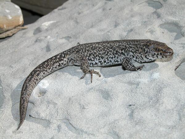
Island Night Lizard on San Nicolas Island - Larger Image
Island Night Lizard on San Nicolas Island - Larger ImageIsland night lizard on San Nicolas Island (May 2007).
Island Night Lizard on San Nicolas Island - Larger Image
Island Night Lizard on San Nicolas Island - Larger ImageIsland night lizard on San Nicolas Island (May 2007).

Drilling for mineral resources near Canyonlands National Park, Utah
Drilling for mineral resources near Canyonlands National Park, UtahDrilling for mineral resources near Canyonlands National Park, Utah
Drilling for mineral resources near Canyonlands National Park, Utah
Drilling for mineral resources near Canyonlands National Park, UtahDrilling for mineral resources near Canyonlands National Park, Utah