



Photo by George Grant, National Park Service (NPS), taken in 1936, public domain.
Images
Below are images associated with SBSC's science and staff. Images appear according to the year they were taken. To search, type a keyword or select a year from the dropdown menu. Or, click through the pages using the arrows at the bottom of the page.
Filter Total Items: 711

Rio Grande River, Big Bend Region
Photo by George Grant, National Park Service (NPS), taken in 1936, public domain.

Historic repeat photograph of Saguaro National Monument East, Rincon Mountain District, 1935
Historic repeat photograph of Saguaro National Monument East, Rincon Mountain District, 1935This is the original photograph in a repeat photographic series of Saguaro National Monument (now Saguaro National Park) East, Rincon Mountain District. This photo was taken in 1935 and is courtesy of the National Park Service (NPS; public domain image) of the abundant 'cactus forest' of saguaros (Carnegiea gigantea).
Historic repeat photograph of Saguaro National Monument East, Rincon Mountain District, 1935
Historic repeat photograph of Saguaro National Monument East, Rincon Mountain District, 1935This is the original photograph in a repeat photographic series of Saguaro National Monument (now Saguaro National Park) East, Rincon Mountain District. This photo was taken in 1935 and is courtesy of the National Park Service (NPS; public domain image) of the abundant 'cactus forest' of saguaros (Carnegiea gigantea).

Historic repeat photograph of Tsegi Canyon, Laguna Creek, northern Arizona, 1927
Historic repeat photograph of Tsegi Canyon, Laguna Creek, northern Arizona, 1927This is the original photo in a repeat photographic series of Tsegi Canyon, Laguna Creek, northern Arizona, north of Rt. 160. The photo was taken in 1927 by J.J. Hanks. Original film courtesy of Northern Arizona University Cline Library Special Collections, public domain.
Historic repeat photograph of Tsegi Canyon, Laguna Creek, northern Arizona, 1927
Historic repeat photograph of Tsegi Canyon, Laguna Creek, northern Arizona, 1927This is the original photo in a repeat photographic series of Tsegi Canyon, Laguna Creek, northern Arizona, north of Rt. 160. The photo was taken in 1927 by J.J. Hanks. Original film courtesy of Northern Arizona University Cline Library Special Collections, public domain.
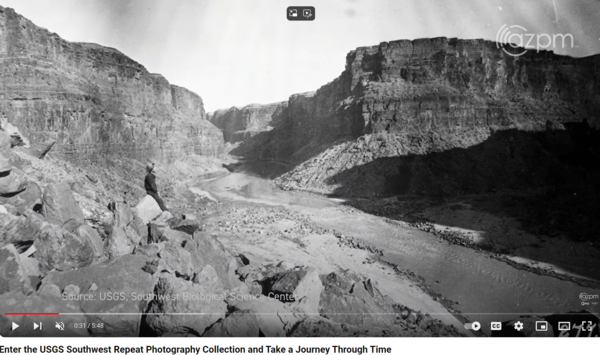
A screenshot of a scene in the AZ PBS video about the Southwest Biological Science Center Repeat Photography Collection
A screenshot of a scene in the AZ PBS video about the Southwest Biological Science Center Repeat Photography CollectionA screenshot of a scene in the AZ PBS video about the Southwest Biological Science Center Repeat Photography Collection. The scene depicts an old photograph taken in the early 1900s along the Colorado River in Grand Canyon. Public domain.
A screenshot of a scene in the AZ PBS video about the Southwest Biological Science Center Repeat Photography Collection
A screenshot of a scene in the AZ PBS video about the Southwest Biological Science Center Repeat Photography CollectionA screenshot of a scene in the AZ PBS video about the Southwest Biological Science Center Repeat Photography Collection. The scene depicts an old photograph taken in the early 1900s along the Colorado River in Grand Canyon. Public domain.

Historic photo taken by EC LaRue along the Colorado River on the Birdseye Expedition, 1923
Historic photo taken by EC LaRue along the Colorado River on the Birdseye Expedition, 1923A historic image taken on September 25, 1923, by E.C. LaRue during a survey trip on the Colorado River in Grand Canyon during the Birdseye Expedition.
Historic photo taken by EC LaRue along the Colorado River on the Birdseye Expedition, 1923
Historic photo taken by EC LaRue along the Colorado River on the Birdseye Expedition, 1923A historic image taken on September 25, 1923, by E.C. LaRue during a survey trip on the Colorado River in Grand Canyon during the Birdseye Expedition.

Lava Falls, Colorado River, Grand Canyon
A historic photo taken by EC LaRue showing the upstream view of the head of Lava Falls, Colorado River, Grand Canyon, "before the flood." The text next to the photos says, "All boats were portaged over the rocks in the foreground during the afternoon of September 18th. 9/18/1923, E.C. LaRue." This is Stake s1732 in the Southwest Repeat Photography Collection.
A historic photo taken by EC LaRue showing the upstream view of the head of Lava Falls, Colorado River, Grand Canyon, "before the flood." The text next to the photos says, "All boats were portaged over the rocks in the foreground during the afternoon of September 18th. 9/18/1923, E.C. LaRue." This is Stake s1732 in the Southwest Repeat Photography Collection.

1923 historic photo of 128-Mile Rapid on the Colorado River in Grand Canyon by E.C. LaRue
1923 historic photo of 128-Mile Rapid on the Colorado River in Grand Canyon by E.C. LaRueRepeat photography images of 128-Mile Rapid on the Colorado River, Grand Canyon, AZ, looking upstream from the top of a schist outcrop just below 128-Mile Rapid from a point on the left bank, 66.8 miles below the Little Colorado River and ½ mile below Specter Chasm, at RM 128.4. Note changes in the debris fan since 1923 that reduced the constriction of the rapid.
1923 historic photo of 128-Mile Rapid on the Colorado River in Grand Canyon by E.C. LaRue
1923 historic photo of 128-Mile Rapid on the Colorado River in Grand Canyon by E.C. LaRueRepeat photography images of 128-Mile Rapid on the Colorado River, Grand Canyon, AZ, looking upstream from the top of a schist outcrop just below 128-Mile Rapid from a point on the left bank, 66.8 miles below the Little Colorado River and ½ mile below Specter Chasm, at RM 128.4. Note changes in the debris fan since 1923 that reduced the constriction of the rapid.

Historic photograph of boats on a beach along the Colorado River in Grand Canyon, 1923 by E.C. LaRue during the Birdseye Expedition
Historic photograph of boats on a beach along the Colorado River in Grand Canyon, 1923 by E.C. LaRue during the Birdseye ExpeditionThis historic photograph shows boats on a beach along the Colorado River in Grand Canyon, by E.C. LaRue during the 1923 Birdseye Expedition through Grand Canyon. The Birdseye Expedition surveyed a 251-mile stretch of the Colorado River from Lees Ferry to Diamond Creek.
Historic photograph of boats on a beach along the Colorado River in Grand Canyon, 1923 by E.C. LaRue during the Birdseye Expedition
Historic photograph of boats on a beach along the Colorado River in Grand Canyon, 1923 by E.C. LaRue during the Birdseye ExpeditionThis historic photograph shows boats on a beach along the Colorado River in Grand Canyon, by E.C. LaRue during the 1923 Birdseye Expedition through Grand Canyon. The Birdseye Expedition surveyed a 251-mile stretch of the Colorado River from Lees Ferry to Diamond Creek.

A man standing near the San Pedro River valley, St. David, southern Arizona, in 1891
A man standing near the San Pedro River valley, St. David, southern Arizona, in 1891A man standing in an open area near St. David, southern Arizona in 1891. Southwest Repeat Photography stake s0151. Photo taken by Roskruge. Original photograph courtesy of the Arizona Historical Society (public domain).
A man standing near the San Pedro River valley, St. David, southern Arizona, in 1891
A man standing near the San Pedro River valley, St. David, southern Arizona, in 1891A man standing in an open area near St. David, southern Arizona in 1891. Southwest Repeat Photography stake s0151. Photo taken by Roskruge. Original photograph courtesy of the Arizona Historical Society (public domain).
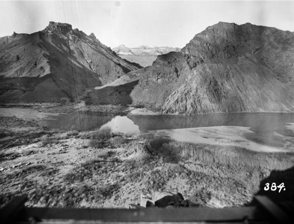
Colorado River, Grand Canyon, River Mile 65.5, Palisades Creek, Across Canyon View from River Left, 1890
Colorado River, Grand Canyon, River Mile 65.5, Palisades Creek, Across Canyon View from River Left, 1890January 22, 1890: Colorado River, Grand Canyon, River Mile 65.5, Palisades Creek, across canyon view from river left. This view looks across the upper part of the Palisades Creek debris fan, across the head of Lava Canyon Rapid, and up Lava Canyon.
Colorado River, Grand Canyon, River Mile 65.5, Palisades Creek, Across Canyon View from River Left, 1890
Colorado River, Grand Canyon, River Mile 65.5, Palisades Creek, Across Canyon View from River Left, 1890January 22, 1890: Colorado River, Grand Canyon, River Mile 65.5, Palisades Creek, across canyon view from river left. This view looks across the upper part of the Palisades Creek debris fan, across the head of Lava Canyon Rapid, and up Lava Canyon.
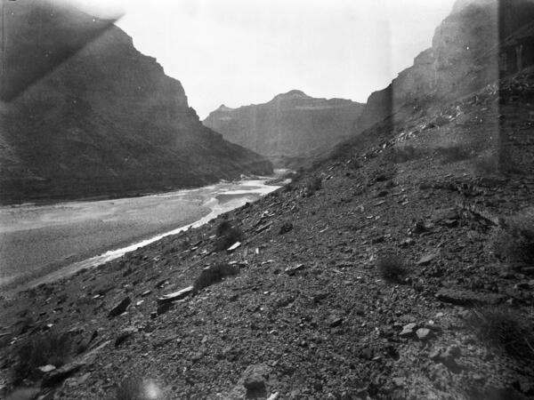
Colorado River, Grand Canyon, River Mile 61.4, Little Colorado River, Downstream View from River Right, 1890
Colorado River, Grand Canyon, River Mile 61.4, Little Colorado River, Downstream View from River Right, 1890January 20, 1890: Colorado River, Grand Canyon, River Mile 61.4, Little Colorado River, Downstream View from River Right. January 20, 1890: Stanton photographed this view looking downstream onto the wide, unvegetated gravel bar that extends downstream from the mouth of the Little Colorado River, which enters the mainstem Colorado River opposite the camera station.
Colorado River, Grand Canyon, River Mile 61.4, Little Colorado River, Downstream View from River Right, 1890
Colorado River, Grand Canyon, River Mile 61.4, Little Colorado River, Downstream View from River Right, 1890January 20, 1890: Colorado River, Grand Canyon, River Mile 61.4, Little Colorado River, Downstream View from River Right. January 20, 1890: Stanton photographed this view looking downstream onto the wide, unvegetated gravel bar that extends downstream from the mouth of the Little Colorado River, which enters the mainstem Colorado River opposite the camera station.
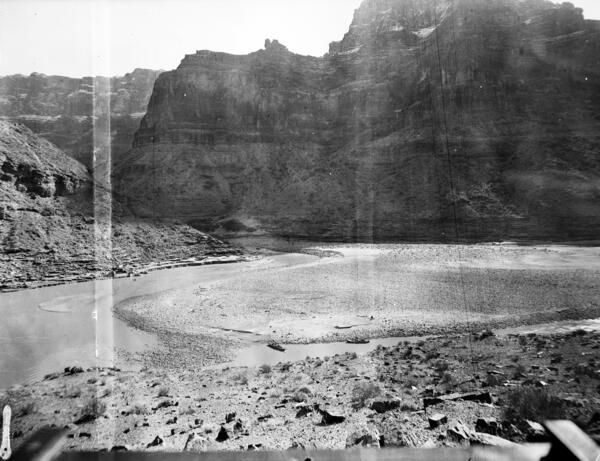
Colorado River, Grand Canyon, River Mile 61.4, Little Colorado River, Across Canyon View from River Right, 1890
Colorado River, Grand Canyon, River Mile 61.4, Little Colorado River, Across Canyon View from River Right, 1890January 20, 1890: Colorado River, Grand Canyon, River Mile 61.4, Little Colorado River, Across Canyon View from River Right. From a ridge with a sweeping view, Stanton captured this image of the confluence of the Little Colorado (left center) and mainstem Colorado (lower left) rivers.
Colorado River, Grand Canyon, River Mile 61.4, Little Colorado River, Across Canyon View from River Right, 1890
Colorado River, Grand Canyon, River Mile 61.4, Little Colorado River, Across Canyon View from River Right, 1890January 20, 1890: Colorado River, Grand Canyon, River Mile 61.4, Little Colorado River, Across Canyon View from River Right. From a ridge with a sweeping view, Stanton captured this image of the confluence of the Little Colorado (left center) and mainstem Colorado (lower left) rivers.
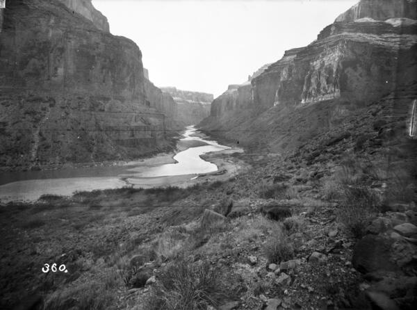
Colorado River, Grand Canyon, River Mile 52.8, Nankoweap, Downstream View from River Right, 1890
Colorado River, Grand Canyon, River Mile 52.8, Nankoweap, Downstream View from River Right, 1890January 18, 1890. Colorado River, Grand Canyon, River Mile 52.8, Nankoweap, Downstream View from River Right. Snow capped the cliffs when Stanton captured this image showing a bend in the river downstream from Nankoweap Creek, a view that is one of the most famous in Grand Canyon.
Colorado River, Grand Canyon, River Mile 52.8, Nankoweap, Downstream View from River Right, 1890
Colorado River, Grand Canyon, River Mile 52.8, Nankoweap, Downstream View from River Right, 1890January 18, 1890. Colorado River, Grand Canyon, River Mile 52.8, Nankoweap, Downstream View from River Right. Snow capped the cliffs when Stanton captured this image showing a bend in the river downstream from Nankoweap Creek, a view that is one of the most famous in Grand Canyon.
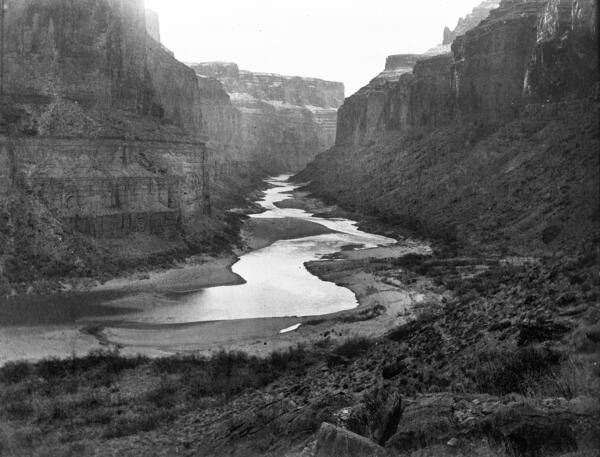
Colorado River, Grand Canyon, River Mile 52.8, Nankoweap, Downstream View from River Right, 1890
Colorado River, Grand Canyon, River Mile 52.8, Nankoweap, Downstream View from River Right, 1890January 18, 1890: Colorado River, Grand Canyon, River Mile 52.8, Nankoweap Creek, Downstream View from River Right. Uncharacteristically, Stanton changed lenses and took two similar views from the same location looking the same direction. This view was taken with what is known as a normal lens, as opposed to the previous view, taken with a wide-angle lens.
Colorado River, Grand Canyon, River Mile 52.8, Nankoweap, Downstream View from River Right, 1890
Colorado River, Grand Canyon, River Mile 52.8, Nankoweap, Downstream View from River Right, 1890January 18, 1890: Colorado River, Grand Canyon, River Mile 52.8, Nankoweap Creek, Downstream View from River Right. Uncharacteristically, Stanton changed lenses and took two similar views from the same location looking the same direction. This view was taken with what is known as a normal lens, as opposed to the previous view, taken with a wide-angle lens.

Historic photo by Nims on Stanton's Colorado River survey trip taken at Lees Ferry
Historic photo by Nims on Stanton's Colorado River survey trip taken at Lees FerryThis image was taken in 1889 by Nims on Stanton's Colorado River survey trip.
Historic photo by Nims on Stanton's Colorado River survey trip taken at Lees Ferry
Historic photo by Nims on Stanton's Colorado River survey trip taken at Lees FerryThis image was taken in 1889 by Nims on Stanton's Colorado River survey trip.

Historic photograph taken in 1889 by Franklin Nims during the Stanton Expedition of the Glen Canyon Dam site, well before it was built on the Colorado River
Historic photograph taken in 1889 by Franklin Nims during the Stanton Expedition of the Glen Canyon Dam site, well before it was built on the Colorado RiverA historic image taken on December 23, 1889 of the Colorado River, River Mile Mile -14.7, of the site where Glen Canyon Dam would later be built. The view is taken upstream from river left in 1889 by Franklin Nims during the Stanton Expedition. Photo credit: Franklin A. Nims, original courtesy of The National Archives, 57-RS-235, public domain.
Historic photograph taken in 1889 by Franklin Nims during the Stanton Expedition of the Glen Canyon Dam site, well before it was built on the Colorado River
Historic photograph taken in 1889 by Franklin Nims during the Stanton Expedition of the Glen Canyon Dam site, well before it was built on the Colorado RiverHistoric photograph taken in 1889 by Franklin Nims during the Stanton Expedition of the Glen Canyon Dam site, well before it was built on the Colorado River
Historic photograph taken in 1889 by Franklin Nims during the Stanton Expedition of the Glen Canyon Dam site, well before it was built on the Colorado RiverA historic image taken on December 23, 1889 of the Colorado River, River Mile Mile -14.7, of the site where Glen Canyon Dam would later be built. The view is taken upstream from river left in 1889 by Franklin Nims during the Stanton Expedition. Photo credit: Franklin A. Nims, original courtesy of The National Archives, 57-RS-235, public domain.

Historic photograph taken in 1889 by Franklin Nims during the Stanton Expedition just downstream of the Glen Canyon Dam site, well before it was built on the Colorado River
Historic photograph taken in 1889 by Franklin Nims during the Stanton Expedition just downstream of the Glen Canyon Dam site, well before it was built on the Colorado RiverA historic image taken on December 23, 1889, of the Colorado River at River Mile Mile -14.7, near the site where Glen Canyon Dam would later be built. The view is taken looking downstream from where the dam is now from river left by Franklin Nims during the Stanton Expedition. Photo credit: Franklin A.
Historic photograph taken in 1889 by Franklin Nims during the Stanton Expedition just downstream of the Glen Canyon Dam site, well before it was built on the Colorado River
Historic photograph taken in 1889 by Franklin Nims during the Stanton Expedition just downstream of the Glen Canyon Dam site, well before it was built on the Colorado RiverHistoric photograph taken in 1889 by Franklin Nims during the Stanton Expedition just downstream of the Glen Canyon Dam site, well before it was built on the Colorado River
Historic photograph taken in 1889 by Franklin Nims during the Stanton Expedition just downstream of the Glen Canyon Dam site, well before it was built on the Colorado RiverA historic image taken on December 23, 1889, of the Colorado River at River Mile Mile -14.7, near the site where Glen Canyon Dam would later be built. The view is taken looking downstream from where the dam is now from river left by Franklin Nims during the Stanton Expedition. Photo credit: Franklin A.

Smallmouth Bass
A curious smallmouth bass following behind scuba divers in Sparkling Lake, Vilas County, Wis.
A curious smallmouth bass following behind scuba divers in Sparkling Lake, Vilas County, Wis.