
Great Lakes tributaries are influenced by a multitude of stressors that may cause adverse ecological effects. The drawing represents 5 of the many significant chemicals effecting the ecosystems – Atrazine, Deet, BPA, Metolachlor, and 4-nonylphenol.
Images
Upper Midwest Water Science Center images.
Filter Total Items: 548

Chemicals of Ecological Concern
Great Lakes tributaries are influenced by a multitude of stressors that may cause adverse ecological effects. The drawing represents 5 of the many significant chemicals effecting the ecosystems – Atrazine, Deet, BPA, Metolachlor, and 4-nonylphenol.

Phosphorus Loading in the Winnebago Pool Lakes
The Winnebago Pool is a chain of 4 shallow lakes in Wisconsin. The drawing relates real-time monitoring as well as sampling that took place on the lakes, the agricultural factors affecting the nutrient loading of the pool, and the importance of the Winnebago Pool fishery.
The Winnebago Pool is a chain of 4 shallow lakes in Wisconsin. The drawing relates real-time monitoring as well as sampling that took place on the lakes, the agricultural factors affecting the nutrient loading of the pool, and the importance of the Winnebago Pool fishery.

Durand streamgage mounted to bridge
Durand streamgage mounted to bridge - looking downstream.
Durand streamgage mounted to bridge - looking downstream.

Hydro-tech using crane to collect a bedload sample from bridge
Hydro-tech using crane to collect a bedload sample from bridgeHydrologic Technician using crane to collect a bedload sample from the bridge.
Hydro-tech using crane to collect a bedload sample from bridge
Hydro-tech using crane to collect a bedload sample from bridgeHydrologic Technician using crane to collect a bedload sample from the bridge.
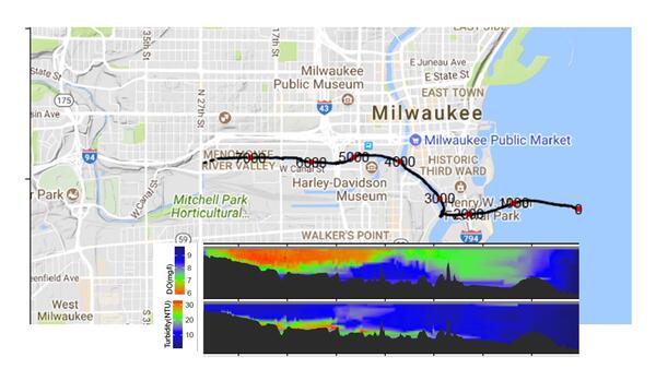
Map dissolved oxygen and turbidity Milwaukee River
Map dissolved oxygen and turbidity Milwaukee RiverMap of dissolved oxygen and turbidity along the Milwaukee River.
These data are preliminary or provisional and are subject to revision. They are being provided to meet the need for timely best science.

Illustration of subsurface-drained agricultural field
Illustration of subsurface-drained agricultural fieldA hypothetical configuration of one of the two drained field sites, including a weather station for measuring climate data, a piezometer network for continuous water level measurements, soil moisture probes, and subsurface drainage flow. The third undrained field site will have a similar configuration, with the absence of subsurface drainage flow.

Mercury research team collecting fish in Everglades
Mercury research team collecting fish in EvergladesUSGS Mercury research team collecting fish in Everglades National Park, Florida.
Mercury research team collecting fish in Everglades
Mercury research team collecting fish in EvergladesUSGS Mercury research team collecting fish in Everglades National Park, Florida.

Panoramic view of sampling site in Everglades
Panoramic view of USGS employees at a sampling site in Florida Everglades.
Panoramic view of USGS employees at a sampling site in Florida Everglades.

Filtration of water in the field at Everglades
Scientists filtering water in the field at Everglades National Park, Florida.
Scientists filtering water in the field at Everglades National Park, Florida.
Field filtration of water in the Florida Everglades
Field filtration of water in the Florida EvergladesUSGS scientists filter water while in the field in the Florida Everglades, to detect mercury in environmental samples.
Field filtration of water in the Florida Everglades
Field filtration of water in the Florida EvergladesUSGS scientists filter water while in the field in the Florida Everglades, to detect mercury in environmental samples.

Two wild turkeys in Wisconsin
A photo of two wild turkeys walking against a wooded background with a dusting of snow in Wisconsin.
A photo of two wild turkeys walking against a wooded background with a dusting of snow in Wisconsin.

One wild turkey in Wisconsin
One wild turkey in Wisconsin

Collecting runoff sample below flume at the Gary City Hall rain garden, Indiana
Collecting runoff sample below flume at the Gary City Hall rain garden, IndianaDanielle Szymkowski, USGS Contractor, collecting runoff sample below a the North Flume (USGS Station ID: 413611087201001) at the Gary City Hall rain garden, Indiana.

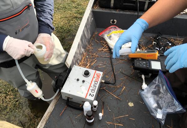
Collecting groundwater sample at Gary City Hall rain garden, Indiana
Collecting groundwater sample at Gary City Hall rain garden, IndianaRandy Bayless (kneeling), USGS Research Hydrologist; Caleb Artz (standing in yellow), USGS Hydrologic Technician; and Danielle Szymkowski (standing in red), USGS Contractor; collect a groundwater sample from well CH-3 (USGS Station ID: 413611087201004) at the Gary City Hall rain garden.

Internal look at the MC-ICP-MS flight tube when magnet is removed
Internal look at the MC-ICP-MS flight tube when magnet is removedInternal look at the MC-ICP-MS flight tube when magnet is removed.
Internal look at the MC-ICP-MS flight tube when magnet is removed
Internal look at the MC-ICP-MS flight tube when magnet is removedInternal look at the MC-ICP-MS flight tube when magnet is removed.

Amy Story repairing data transmission system at Gary City Hall rain garden
Amy Story repairing data transmission system at Gary City Hall rain gardenHydrologic Technician Amy Story repairing the data-transmission system at the Gary City Hall (Indiana) rain garden. The data-transmission system gathers data from several instruments and provides it in real time to the USGS web site.

Caleb Artz installing a heated precipitation gage
Caleb Artz, USGS Hyrologic Technician, installing a heated precipitation gage (USGS station ID: 413611087201301) to measure rain and snow falling at the Gary City Hall rain garden.
Caleb Artz, USGS Hyrologic Technician, installing a heated precipitation gage (USGS station ID: 413611087201301) to measure rain and snow falling at the Gary City Hall rain garden.

Puffin flying at Izembek National Wildlife Refuge Alaska with Frosty Peak in background
Puffin flying at Izembek National Wildlife Refuge Alaska with Frosty Peak in backgroundPuffin flying at Izembek National Wildlife Refuge Alaska with Frosty Peak in background.
Puffin flying at Izembek National Wildlife Refuge Alaska with Frosty Peak in background
Puffin flying at Izembek National Wildlife Refuge Alaska with Frosty Peak in backgroundPuffin flying at Izembek National Wildlife Refuge Alaska with Frosty Peak in background.
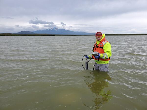
Hydrologist takes water chemistry measures on the Alaska Peninsula
Hydrologist takes water chemistry measures on the Alaska PeninsulaLaura Hubbard of the USGS Upper Midwest Water Science Center takes water chemistry measures on the Alaska Peninsula as part of research to understand how long influenza viruses remain viable in the environment.

Harbor seals in Russell Creek, Cold Bay, Alaska.
Harbor seals poking their heads above water near shore in Russell Creek, Cold Bay, Alaska.
Harbor seals poking their heads above water near shore in Russell Creek, Cold Bay, Alaska.

Longitudinal profiles of estuary depth (in meters) and water temperature in the Milwaukee River Estuary for the Milwaukee, Menomonee, and Kinnickinnic Rivers, as well as South Menomonee Canal for August 30, 2019
Longitudinal profiles of estuary depth (in meters) and water temperature in the Milwaukee River Estuary for the Milwaukee, Menomonee, and Kinnickinnic Rivers, as well as South Menomonee Canal for August 30, 2019Longitudinal profiles of estuary depth (in meters) and water temperature in the Milwaukee River Estuary for the Milwaukee, Menomonee, and Kinnickinnic Rivers, as well as South Menomonee Canal (S. Canal) for August 30, 2019.
Longitudinal profiles of estuary depth (in meters) and water temperature in the Milwaukee River Estuary for the Milwaukee, Menomonee, and Kinnickinnic Rivers, as well as South Menomonee Canal for August 30, 2019
Longitudinal profiles of estuary depth (in meters) and water temperature in the Milwaukee River Estuary for the Milwaukee, Menomonee, and Kinnickinnic Rivers, as well as South Menomonee Canal for August 30, 2019Longitudinal profiles of estuary depth (in meters) and water temperature in the Milwaukee River Estuary for the Milwaukee, Menomonee, and Kinnickinnic Rivers, as well as South Menomonee Canal for August 30, 2019
Longitudinal profiles of estuary depth (in meters) and water temperature in the Milwaukee River Estuary for the Milwaukee, Menomonee, and Kinnickinnic Rivers, as well as South Menomonee Canal for August 30, 2019Longitudinal profiles of estuary depth (in meters) and water temperature in the Milwaukee River Estuary for the Milwaukee, Menomonee, and Kinnickinnic Rivers, as well as South Menomonee Canal (S. Canal) for August 30, 2019.