
Hydrologic Hazards
Featured Science | Post-wildfire Reservoir Sedimentation
Assessing sediment and water quality in the Conconully Reservoir and surrounding streams after a wildfire.
Featured Science | Lower Duwamish Valley Hydrogeologic Framework
Creating a hydrogeologic framework to support simulations of extreme hydrologic conditions.
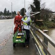
Featured Science | Bear Gulch Fire Water Quality Monitoring
We are monitoring water quality in the North Fork Skokomish River following the Bear Gulch Fire.
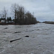
Too much water or too little can cause serious problems for the people and other species reliant on water. In addition to real-time monitoring of conditions across Washington State, we investigate how extreme events like wildfires and floods impact hydrologic systems.
Floods
The USGS monitors streamflow, river levels, and reservoir elevations at over 350 locations in Washington State. Real-time data from rivers are used by other federal agencies and cooperative partners to mitigate flood hazards. We also investigate long-term trends in flooding, the impacts of flooding on hydrologic processes, and other flood-related science topics.
Wildfire
Wildfires can compromise water quality. Burned watersheds are prone to increased flooding and erosion, which can negatively affect water-supply reservoirs, water quality, and drinking-water treatment processes. We measure and predict post-fire water quality and quantity to help water providers prepare for and mitigate these impacts.
Land Use Change
Land and water are closely connected. We research how land use influences water resources, aquatic ecosystems, and water quality. We work in urban areas, forests, agricultural fields, and rural communities. Our research focuses on determining the interactions between physical, chemical and biological stressors.
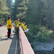
Testing non-contact discharge measurement methods in the Nooksack River
Bear Gulch Fire Water Quality Monitoring
Green River Sediment Monitoring

Hoh geomorphology

Nooksack geomorphology

Ice Jams on Osoyoos Lake

Bolt Creek Wildfire Sediment Runoff and Water Quality

Hydrogeologic Framework for the Duwamish River Valley to the Lake Washington Ship Canal, Washington

Post-wildfire sedimentation and release of metals to Conconully Reservoir, Washington

Analysis of USGS Surface Water Monitoring Networks

Channel change monitoring following the Pilchuck Dam removal
