
StreamStats is a digital, map-based tool designed to provide information about streamflow and the upstream watershed of any selected point on a stream. The tool can assist in water resources planning and management and support engineering and design projects. In Wyoming, the current capabilities of the application are basin delineations and basin-characteristics.
What can StreamStats do in Wyoming?
Wyoming StreamStats includes basin delineation and basin characteristics, but additional data and capabilities are in development. The current version of StreamStats allows users to select or enter a stream location, delineate the drainage basin for the selected location, and compute basin characteristics. A future version of Wyoming StreamStats will expand its functionality to include streamflow statistics for any stream segment in Wyoming. Data provided will include mean annual streamflow, mean monthly streamflow, flow duration curves, peak flow frequency, and low flow frequency.
In addition to using the StreamStats tools in the application, users can also visit the Wyoming Regional StreamStats Information Portal. This portal displays the data and information that are available for download and drainage calculation.
A user guide is also available for Wyoming StreamStats. This guide includes step-by-step instructions on how to use the application, including how to delineate a basin, build a report, and more.
Check out the Wyoming StreamStats user guide
Use the StreamStats Application
Updates to Wyoming StreamStats
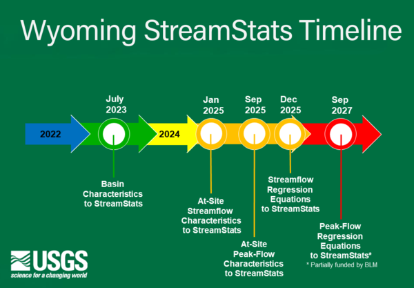
The development of Wyoming StreamStats is the result of a collaborative effort between the USGS and the Wyoming Water Development Office. Three more analytical components are in development: peak-flow characteristics at gaging stations, regional regression equations to estimate streamflow characteristics at ungaged sites, and, with additional assistance from the Bureau of Land Management, peak-flow regressions at ungaged sites. Work on these updates began in 2018. They are expected to be completed in the fall of 2027.
Below is a tentative timeline for updates to the Wyoming StreamStats application.
StreamStats for Wyoming can be used to estimate streamflow under natural streamflow conditions for the following statistics: 7-day, 2-year low flow (M7D2Y); 7-day, 10-year low flow (M7D10Y); 14-day, 5-year low flow (M14D5Y); 30-day, 5-year low flow (M30D5Y); 60-day, 2-year high flow (V60D2Y); 1-day, 5-year high flow (V1D5Y); 0.1-, 0.2-, 0.5-, 1-, 2-, 4-, 5-, 10-, 20-, 25-, 30-, 50-, 60-, 70-, 75-, 80-, 90-, 95-, 98-, and 99-percent durations for annual streamflows; and 0.1-, 0.5-, 10-, 15-, 20-, 25-, 30-, 40-, 50-, 60-, 70-, 75-, 80-, 85-, 90-, 95-, and 99- percent durations for monthly streamflows for most months.
The reports below present the methods used for calculating the respective streamflow statistics at USGS streamgages, and methods used to develop the regression models for estimating the streamflow statistics at ungaged basins using the basin characteristics.
The data releases below contain foundational layers and metadata, and streamgage watershed averages for all basin characteristics used in this study.
StreamStats is a digital, map-based tool designed to provide information about streamflow and the upstream watershed of any selected point on a stream. The tool can assist in water resources planning and management and support engineering and design projects. In Wyoming, the current capabilities of the application are basin delineations and basin-characteristics.
What can StreamStats do in Wyoming?
Wyoming StreamStats includes basin delineation and basin characteristics, but additional data and capabilities are in development. The current version of StreamStats allows users to select or enter a stream location, delineate the drainage basin for the selected location, and compute basin characteristics. A future version of Wyoming StreamStats will expand its functionality to include streamflow statistics for any stream segment in Wyoming. Data provided will include mean annual streamflow, mean monthly streamflow, flow duration curves, peak flow frequency, and low flow frequency.
In addition to using the StreamStats tools in the application, users can also visit the Wyoming Regional StreamStats Information Portal. This portal displays the data and information that are available for download and drainage calculation.
A user guide is also available for Wyoming StreamStats. This guide includes step-by-step instructions on how to use the application, including how to delineate a basin, build a report, and more.
Check out the Wyoming StreamStats user guide
Use the StreamStats Application
Updates to Wyoming StreamStats
The development of Wyoming StreamStats is the result of a collaborative effort between the USGS and the Wyoming Water Development Office. Three more analytical components are in development: peak-flow characteristics at gaging stations, regional regression equations to estimate streamflow characteristics at ungaged sites, and, with additional assistance from the Bureau of Land Management, peak-flow regressions at ungaged sites. Work on these updates began in 2018. They are expected to be completed in the fall of 2027.
Below is a tentative timeline for updates to the Wyoming StreamStats application.
StreamStats for Wyoming can be used to estimate streamflow under natural streamflow conditions for the following statistics: 7-day, 2-year low flow (M7D2Y); 7-day, 10-year low flow (M7D10Y); 14-day, 5-year low flow (M14D5Y); 30-day, 5-year low flow (M30D5Y); 60-day, 2-year high flow (V60D2Y); 1-day, 5-year high flow (V1D5Y); 0.1-, 0.2-, 0.5-, 1-, 2-, 4-, 5-, 10-, 20-, 25-, 30-, 50-, 60-, 70-, 75-, 80-, 90-, 95-, 98-, and 99-percent durations for annual streamflows; and 0.1-, 0.5-, 10-, 15-, 20-, 25-, 30-, 40-, 50-, 60-, 70-, 75-, 80-, 85-, 90-, 95-, and 99- percent durations for monthly streamflows for most months.
The reports below present the methods used for calculating the respective streamflow statistics at USGS streamgages, and methods used to develop the regression models for estimating the streamflow statistics at ungaged basins using the basin characteristics.
The data releases below contain foundational layers and metadata, and streamgage watershed averages for all basin characteristics used in this study.